Marine Navigation - Canada - Offline Gps Nautical Charts for Fishing, Sailing and Boating App Reviews
Marine Navigation - Canada - Offline Gps Nautical Charts for Fishing, Sailing and Boating App Description & Overview
What is marine navigation - canada - offline gps nautical charts for fishing, sailing and boating app? GPS Marine Charts App offers access to charts covering Canada (derived from CHS data). Only marine GPS app to have route assistance with Voice Prompts for marine navigation. It has route manager to create new boating routes or import existing GPX/KML routes. It supports Nautical Charts course up orientation.
Please visit
http://gpsnauticalcharts.com/main/ca-nautical-charts-by-folio.html for
complete list. If you don't find the chart for Canada , please contact us at support at gpsnauticalcharts.com.
(Includes coverage for Trent Severn Waterway incl. lake Simcoe etc.)
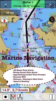
* Voice Prompts for marine navigation (requires GPS )
-prompts when approaching a boating route marker
-Continous distance and ETA updates
-Alerts when sailing/boating off route
-Alerts when boating in wrong direction
*Route Editing/Creation
-Create routes from scratch
-Edit existing GPX/KML routes.
-Add custom description to any route point.
-Drop markers along route.
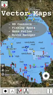
* Offline charts derived from CHS data.
-Visually draw area to download
-Textual search
-Catalog (By state, region and coast guard district)
-Charts reprojected for WGS84 datum
*Seamless chart quilting of marine charts
*Distance Bearing tool
*Create custom way points
- Using GPS
-Select point on map
-Manually enter latitude & longitude coordinates
*POI layer for marine charts
- Overlay POIs
- POI list derived from the equivalent ENC and contains all categories including Buoy, Light, Harbour facility, Obstr.
*Search POIs/Way points
*Pan/Zoom/My Location
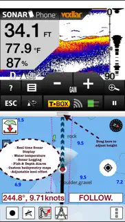
* Record Marine GPS tracks
* View tracks overlay
* Live track animation
* Track analytics/stats
* Export GPX tracks.
-Export to SDCard
-Share GPX trakcs with friends.
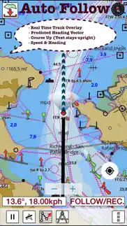
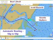
* Auto Follow Mode (Course up)
-Continuously updates boat's location on chart
- Adjustable update frequency
Sample Nautical Charts (please visit http://www.gpsnauticalcharts.com/ for complete list)
Pacific Coast - Vancouver Island East & West - Haida Gwaii
Great lakes Canada and St. Lawrence river
Trent-Severn Waterway
BALSAM LAKE
BALSAM LAKE TO/À BOLSOVER (LOCK/ÉCLUSE)
BOLSOVER (LOCK/ÉCLUSE) TO/AU LAKE SIMCOE
CAMERON LAKE
CHEMONG LAKE
ÉCLUSES DE HEALY FALLS LOCKS TO/AU RICE LAKE
LAKE COUCHICHING - LAKE SIMCOE TO/À COUCHICHING LOCK/L'ÉCLUSE DE COUCHICHING
LAKEFIELD
LAKEFIELD LOCK/ÉCLUSE 26
LAKEFIELD TO/À BURLEIGH FALLS
LAKE SCUGOG
LAKE SIMCOE
PETERBOROUGH TO/À LAKEFIELD
PIGEON LAKE (NORTH PORTION/PARTIE NORD)
PIGEON LAKE (SOUTH PORTION/PARTIE SUD)
RICE LAKE
RICE LAKE TO/À PETERBOROUGH
STONY LAKE
STURGEON LAKE
Lake Erie \ Lac Erie
Lake Huron\Lac Huron
Lake Huron\Lac Huron (Southern Portion\Partie sud)
Lake Ontario\Lac Ontario
Lake Ontario\Lac Ontario, Western Portion\Partie ouest
Lake St. Francis
Lake Superior\Lac Superieur
Vancouver Harbour, Central Portion\Partie Centrale
Vancouver Harbour, Eastern Portion\Partie Est
Vancouver Harbour, Western Portion\Partie Ouest
Vancouver Island\Ile de Vancouver, Juan de Fuca Strait to\a Queen Charlotte
Strait of Georgia
BARRIE
BATAWA LOCK / ÉCLUSE 4
BEAVERTON HARBOUR
BENSFORT BRIDGE TO/À PETERBOROUGH
BIG CHUTE
BIG CHUTE MARINE RAILWAYS BER ROULANT
BIG CHUTE TO / À PORT SEVERN
BOBCAYGEON - LOCK/ÉCLUSE 32
BOBCAYGEON - LOCK/ÉCLUSE 32
BOBGAYGEON - LOCK/ÉCLUSE 32
BUCKHORN
BUCKHORN - LOCK/ÉCLUSE 31
BUCKHORN TO/À GANNON NARROWS AND/ET HARRINGTON NARROWS
BURLEIGH FALLS
BURLEIGH FALLS LOCK/ÉCLUSE 28
BURLEIGH FALLS TO/À BUCKHORN
CAMPBELLFORD LOCK / ÉCLUSE 13
COOK'S BAY AND/ET HOLLAND RIVER
COUCHICHING LOCK / ÉCLUSE 42
COUCHICHING LOCK TO BIG CHUTE ÉCLUSE COUCHICHING À BIG CHUTE
CROWE BAY LOCK / ÉCLUSE 14
DOURO LOCK/ÉCLUSE 24
FENELON FALLS - LOCK/ÉCLUSE 34
FRANKFORD LOCK / ÉCLUSE 6
GANNON NARROWS TO/À BOBCAYGEON
GLEN MILLER LOCK / ÉCLUSE
GLEN ROSS LOCK
PLEASE NOTE: Continued use of GPS running in the background can dramatically decrease battery life.
- Marine Navigation - Canada - Offline Gps Nautical Charts for Fishing, Sailing and Boating Comments & Reviews in 2024
- Marine Navigation - Canada - Offline Gps Nautical Charts for Fishing, Sailing and Boating Tips & Tricks
- Marine Navigation - Canada - Offline Gps Nautical Charts for Fishing, Sailing and Boating Screenshots & Images
😍 Do you love Marine Navigation - Canada - Offline Gps Nautical Charts for Fishing, Sailing and Boating app? Please share your friends!

Please wait! Marine Navigation - Canada - Offline Gps Nautical Charts for Fishing, Sailing and Boating app comments loading...
Marine Navigation - Canada - Offline Gps Nautical Charts for Fishing, Sailing and Boating 136.0.0 Tips, Tricks, Cheats and Rules
What do you think of the Marine Navigation - Canada - Offline Gps Nautical Charts for Fishing, Sailing and Boating app? Can you share your complaints, experiences, or thoughts about the application with Bist LLC and other users?
Marine Navigation - Canada - Offline Gps Nautical Charts for Fishing, Sailing and Boating 136.0.0 Apps Screenshots & Images
Marine Navigation - Canada - Offline Gps Nautical Charts for Fishing, Sailing and Boating iphone, ipad, apple watch and apple tv screenshot images, pictures.
| Language | English |
| Price | $25.99 |
| Adult Rating | 4+ years and older |
| Current Version | 136.0.0 |
| Play Store | com.skiracer.camarine |
| Compatibility | iOS 8.0 or later |
Marine Navigation - Canada - Offline Gps Nautical Charts for Fishing, Sailing and Boating (Versiyon 136.0.0) Install & Download
The application Marine Navigation - Canada - Offline Gps Nautical Charts for Fishing, Sailing and Boating was published in the category Navigation on 25 February 2013, Monday and was developed by Bist LLC [Developer ID: 452642934]. This program file size is 49.23 MB. This app has been rated by 1 users and has a rating of 5 out of 5. Marine Navigation - Canada - Offline Gps Nautical Charts for Fishing, Sailing and Boating - Navigation app posted on 24 October 2023, Tuesday current version is 136.0.0 and works well on iOS 8.0 and higher versions. Google Play ID: com.skiracer.camarine. Languages supported by the app:
NL EN FI FR DE NB RU SV Download & Install Now!| App Name | Score | Comments | Price |
| Fishing Points - Lake Maps Reviews | 4.4 | 1,931 | Free |
| Marine Navigation UK Ireland Reviews | 1 | No comment | $39.99 |
| Marine Navigation - Lake Depth Maps - USA - Offline Gps Nautical Charts for Fishing, Sailing and Boating Reviews | 4.3 | 16 | $22.99 |
| Marine Navigation - Canada Reviews | 5 | 1 | $25.99 |
- New lakes and updates for ON,QC, BC and AB - Auto Routing - Tide & Currents update - Marine weather (wind, gust, wave, precipitation, temperature, pressure etc) - Dark Theme Support - Magnetic Bearing - Compiled with latest version of Xcode
| App Name | Released |
| Electrify America | 03 June 2019 |
| Neshan Map | 04 May 2023 |
| PlugShare | 07 March 2011 |
| Speedometer Simple | 18 November 2014 |
| KakaoMap - Korea No.1 Map | 27 February 2009 |
Find on this site the customer service details of Marine Navigation - Canada - Offline Gps Nautical Charts for Fishing, Sailing and Boating. Besides contact details, the page also offers a brief overview of the digital toy company.
| App Name | Released |
| Sun Seeker - Tracker, Surveyor | 04 October 2009 |
| IMotoneige | 02 December 2017 |
| Wasatch Backcountry Skiing Map | 01 October 2013 |
| Aprs.fi | 02 December 2015 |
| GoSkyWatch Planetarium | 31 January 2019 |
Discover how specific cryptocurrencies work — and get a bit of each crypto to try out for yourself. Coinbase is the easiest place to buy and sell cryptocurrency. Sign up and get started today.
| App Name | Released |
| Google Chrome | 28 June 2012 |
| PayPal - Send, Shop, Manage | 03 February 2019 |
| CapCut - Video Editor | 14 April 2020 |
| Airbnb | 10 November 2010 |
| Amazon Shopping | 03 December 2008 |
Looking for comprehensive training in Google Analytics 4? We've compiled the top paid and free GA4 courses available in 2024.
| App Name | Released |
| FL Studio Mobile | 21 June 2011 |
| Papers, Please | 12 December 2014 |
| Slay the Spire | 13 June 2020 |
| HotSchedules | 30 October 2008 |
| Incredibox | 27 March 2016 |
Each capsule is packed with pure, high-potency nootropic nutrients. No pointless additives. Just 100% natural brainpower. Third-party tested and validated by the Clean Label Project.
Adsterra is the most preferred ad network for those looking for an alternative to AdSense. Adsterra is the ideal choice for new sites with low daily traffic. In order to advertise on the site in Adsterra, like other ad networks, a certain traffic limit, domain age, etc. is required. There are no strict rules.
The easy, affordable way to create your professional portfolio website, store, blog & client galleries. No coding needed. Try free now.
Marine Navigation - Canada - Offline Gps Nautical Charts for Fishing, Sailing and Boating Comments & Reviews 2024
We transfer money over €4 billion every month. We enable individual and business accounts to save 4 million Euros on bank transfer fees. Want to send free money abroad or transfer money abroad for free? Free international money transfer!
Great app. Works as it should!
Great App - Even Better Support. As unfamiliar as I am with nautical charts, I still find myself having to navigate the challenging waters of Puget Sound in Washington State. The App itself is straight forward and gives you a wealth of complete charts at your fingertips. What is even better: Tech Support is quick to respond and genuinely interested in helping solve problems. The App doesn't misbehave at all - ever!
Did you know that you can earn 25 USD from our site just by registering? Get $25 for free by joining Payoneer!
Imagine you at your best. All the time. Picture yourself at your sharpest and most productive. Your most alert and focused. Your most lucid, creative and confident. At work. At play. In every area of your life. Add Mind Lab Pro® v4.0 to your daily routine and uncap your true potential. Buy Now!
Outstanding app for price and content. I bought this app hoping I would get maps for a couple places I was interested in (Ottawa River and the st Lawrence seaway) but this app has maps for every other little lake I could possibly want too! The features are great too, waypoint and record routes work really well. Thanks for making a truly essential app for any boater!
Great app. This looks like a great app.
The best nav system for central canada. As stated. The only real system available for manitoba
Great app. I have used in low light and visibility and found it to be very accurate. Wish it would make a auto course from point to point. As well as have more information about the nav points on charts in a side menu so I don't have to also have my books with me. Great app thou I use it all the time, very accurate. Thanks.
Great Lakes Day Trips. For a small boat and day trips this app gives you all the information you need to navigate with confidence. I circled Manitoulin Island safely with my kids. Markers were very precise. Thank you for bringing safety within reach of a simple app. Inner lakes would be better in the same format as Great Lakes. But the charts look useful.
Does not work.. No charts came with this. It offers to download them at additional cost, which then does not work. If you want an expensive app which does nothing but put a blinking curser on your present location then this is for you.
RIP-OFF DONT WASTE YOUR MONEY. Advertised for $19.99. Charged my account $34.00! Very little to no useful info in my area. Contacted app support NO REPLY! Poor user interface as choppy contour lines. Eats up huge data space holing mapped areas. Not possible to load small areas. Must download whole charts. WASTE OF $30.00
Customer service. I purchased this apt to use it as a backup to other navigational equipment. This is in my opinion a waste of money. I contacted the help department several times (no phone number to call) but they could only answer some of my concerns.
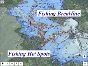
Great app!. If you live in Ottawa Valley area and would like the nautical maps for the Ottawa River. This is exactly what you need. Full on waypoints, GPS route tracking and much more. Fish sand bars or avoid those shallow areas! Get this app!
Cheated me out of $20. Bought this app when it was $20 on app store. To my surprize a year later the app is asking me to cough up another $20. Nowere it said that it is a yearly subscription app. Barely even got to use it.
Defective. Would be fine if all charts for a particular area were available for downloading; but they aren't. It's partially CHS's fault. However this app producer is not interested in fixing the problem, and won't provide a refund.
excellent app. I have used this excellent app for over a year. Recently I had a problem with the gps and contacted their support tech. After a few emails he found the problem and fixed it. I was very impressed with both the prompt replies and the tech's expertise. Excellent app and excellent support I highly recommend it.
Pas la Rivière de la Lièvre visible. Nous n’avons pas notre rivière visible. Rivière de la Lièvre , Notre Dame do Laus. Québec
Excellent!. Detailed charts, accurate positioning, effective for recreational navigation, excellent and prompt support.
Great ap. Does a great job of delivering everything as promised. I am using it on an Ipad Air and it's fast, tracks well and does not crash. Great job designers!!!!
Used on Lake of Bays in muskoka canada. Absolutely worked flawlessly. Very easy to input and follow. A must have for recreational boater. Still use the offices charts as well
Don't waste your money!. Not what you think it is do not but rip off scam!
Great App. We have used two consecutive days on the Ottawa River, this was a fantastic app to have for us novice boaters without all the fancy fish & depth finders aboard , could make use of a legend for all the symbols as part of the features, but other than that, definitely not a waste of money , Nautical maps aren't cheap !
Great app for the price. Have been using the app for several months now, learning to use the application wasn't overly difficult. One upgrade could be labels on the buttons. Also a more easily accessible users guide. I had a problem with missing tidal station info, sent an email and within the day issue was resolved. Over all a good app for navigation information.
App requests new map purchases every year. Loses prior year's map purchases and data. Costly at $22+ every year. Not worth it.
Good functionality. No problems and good accuracy. Would like to see contour lines for adjacent shores like hard-copy charts. Would also like to see Lat/Lon for current points or markers.
Adsterra is the most preferred ad network for those looking for an alternative to AdSense. Adsterra is the ideal choice for new sites with low daily traffic. In order to advertise on the site in Adsterra, like other ad networks, a certain traffic limit, domain age, etc. is required. There are no strict rules. Sign up!