4WD Maps - Offline Topo Maps App Reviews
4WD Maps - Offline Topo Maps App Description & Overview
What is 4wd maps - offline topo maps app? Best value Hema App. The one-time cost includes all Hema 4WD maps, without any recurring subscriptions.
Use offline mapping and your device’s in-built GPS receiver to see where you are on detailed Hema maps, which feature roads, 4WD tracks, topographic information and POIs to guide your travels off the beaten track.
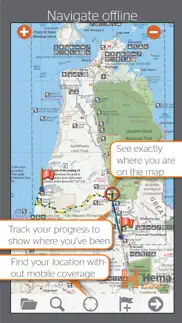
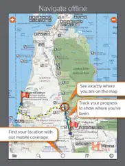
NAVIGATE OFFLINE
Find your location
Real-time GPS tracking*
Australia-wide map coverage
Simple zooming
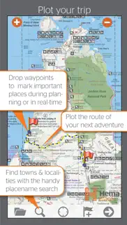
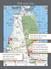
PLOT YOUR TRIP
Drop waypoints
Plan routes
Placename search
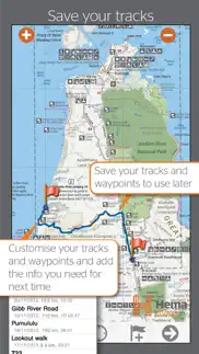
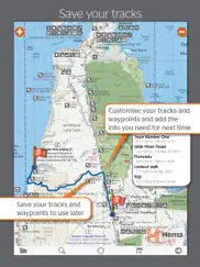
SAVE & RECORD YOUR TRACKS
Record your trips
Create tracklogs
Save tracks with information
Share tracklogs & waypoints
ACCESS HEMA'S PREMIUM MAP COLLECTION
The app comes preloaded with a massive library of Hema touring and 4WD maps that covers all of Australia:
Base Maps:
Australia 1:250K TOPO
Hema Explorer Map at 1:150,000 - 1:10M
Goldfields-Esperance - Cape Arid NP
Goldfields-Esperance - Cape Le Grand NP
Cape York - The CREB Track
Cape York - Lakefield NP
Cape York - The Tip
Goldfields-Esperance - Fitzgerald River NP
Flinders - Flinders Ranges Mainmap
Flinders - Mount Remarkable NP
Flinders - Flinders Ranges NP
Flinders - Vulkathunha Gammon Ranges NP
Fraser Island - Central Station
Fraser Island - Mid Fraser
Fraser Island - Rainbow Beach
Great Desert Tracks - North Central
Great Desert Tracks - North East
Great Desert Tracks - North West
Great Desert Tracks - South Central
Great Desert Tracks - South East
Great Desert Tracks - South West
Goldfields-Esperance and Southern Coast of WA
Goldfields-Esperance Region
High Country Victoria East
High Country Victoria West
Top End - Kakadu National Park
Outback NSW - Kinchega NP
Sth West Corner - Margaret River Wine Region
Mid West Western Australia
Mid West WA - Francois Peron NP
Mid West WA - Kalbarri NP
Mid West WA - Kennedy Range NP
Mid West WA - Mount Augustus NP
Outback NSW - Mungo NP
Outback NSW - Mutawintji NP
Outback New South Wales
Outback Queensland
Outback QLD - Bladensburg NP
Outback QLD - Carnarvon Gorge
Outback QLD - Currawinya NP
Outback QLD - Diamantina NP
Outback QLD - Idalia NP
Outback QLD - Mt Moffat
Outback QLD - Salvator Rosa and Ka Ka Mundi
Pilbara
Pilbara - Cape Range NP
Pilbara - Karijini NP
Pilbara - Millstream Chichester NP
Pilbara - Rudall River Karlamilyi NP
Simpson Desert 1:1,100,000
Simpson Desert 1:500,00
South West Corner - 200k
South West Western Australia
Goldfields-Esperance - Stirling Ranges NP
Goldfields-Esperance - Stokes NP
Outback NSW - Sturt NP
The Kimberley
The Kimberley - Dampier Peninsula
The Kimberley - Purnululu NP
The Kimberley - Wyndham-Kununurra
The Red Centre
Top End and Gulf - Boodjamulla NP
Top End and Gulf - Darwin Region
Top End and Gulf - Gregory NP
Top End and Gulf - Keep River NP
Top End and Gulf - Nhulunbuy
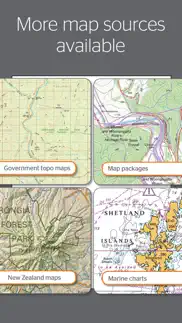
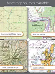
DOWNLOAD ADDITIONAL MAP SOURCES
Access a wide range of additional map sources which are available for purchase via the Memory-Map Digital Map Shop.
USE ON WINDOWS PC or MAC
Use the same maps and overlays on your desktop/laptop to plan your route and review tracklogs. (Maps sold separately).
*You do not need a SIM Card installed or cellular coverage to utilise the GPS tracking functions on iPad for the app, though a WiFi+Cellular iPad is necessary to discover and track your location. A WiFi-only iPad does not contain the in-built GPS that a WiFi+Cellular iPad does, however external Bluetooth GPS receivers can be purchased for use with a WiFi-only iPad.
😍 Do you love 4WD Maps - Offline Topo Maps app? Please share your friends!

Please wait! 4WD Maps - Offline Topo Maps app comments loading...
4WD Maps - Offline Topo Maps 2.4.2 Tips, Tricks, Cheats and Rules
What do you think of the 4WD Maps - Offline Topo Maps app? Can you share your complaints, experiences, or thoughts about the application with Hema Maps and other users?
4WD Maps - Offline Topo Maps 2.4.2 Apps Screenshots & Images
4WD Maps - Offline Topo Maps iphone, ipad, apple watch and apple tv screenshot images, pictures.
| Language | English |
| Price | $64.99 |
| Adult Rating | 4+ years and older |
| Current Version | 2.4.2 |
| Play Store | au.com.hemamaps.aust4wd |
| Compatibility | iOS 11.4 or later |
4WD Maps - Offline Topo Maps (Versiyon 2.4.2) Install & Download
The application 4WD Maps - Offline Topo Maps was published in the category Navigation on 22 November 2011, Tuesday and was developed by Hema Maps [Developer ID: 420014626]. This program file size is 1.7 GB. This app has been rated by 4 users and has a rating of 2.2 out of 5. 4WD Maps - Offline Topo Maps - Navigation app posted on 07 September 2022, Wednesday current version is 2.4.2 and works well on iOS 11.4 and higher versions. Google Play ID: au.com.hemamaps.aust4wd. Languages supported by the app:
EN Download & Install Now!| App Name | Score | Comments | Price |
| 4x4 Explorer Reviews | 1 | No comment | $31.99 |
Updated Maps: Great Desert Tracks & Simpson Desert New Map: Nullarbor Plain Easier to tap toolbar buttons on iPhone (swipe home twice to close the app)
| App Name | Released |
| Neshan Map | 04 May 2023 |
| Google Maps | 12 December 2012 |
| Footpath Route Planner | 07 May 2013 |
| New York Subway MTA Map | 03 May 2010 |
| ParkHouston | 05 May 2017 |
Find on this site the customer service details of 4WD Maps - Offline Topo Maps. Besides contact details, the page also offers a brief overview of the digital toy company.
| App Name | Released |
| World Tides 2024 | 14 November 2023 |
| Ski Tracks | 05 April 2010 |
| Blitzer.de PRO | 03 August 2022 |
| AyeTides | 06 February 2019 |
| NZ Topo50 South Island | 27 February 2013 |
Discover how specific cryptocurrencies work — and get a bit of each crypto to try out for yourself. Coinbase is the easiest place to buy and sell cryptocurrency. Sign up and get started today.
| App Name | Released |
| Uber - Request a ride | 20 May 2010 |
| 12 February 2019 | |
| DoorDash - Food Delivery | 10 October 2013 |
| TikTok | 02 April 2014 |
| Cash App | 16 October 2013 |
Looking for comprehensive training in Google Analytics 4? We've compiled the top paid and free GA4 courses available in 2024.
| App Name | Released |
| Pou | 26 November 2012 |
| HotSchedules | 30 October 2008 |
| Terraria | 28 August 2013 |
| Papers, Please | 12 December 2014 |
| AnkiMobile Flashcards | 26 May 2010 |
Each capsule is packed with pure, high-potency nootropic nutrients. No pointless additives. Just 100% natural brainpower. Third-party tested and validated by the Clean Label Project.
Adsterra is the most preferred ad network for those looking for an alternative to AdSense. Adsterra is the ideal choice for new sites with low daily traffic. In order to advertise on the site in Adsterra, like other ad networks, a certain traffic limit, domain age, etc. is required. There are no strict rules.
The easy, affordable way to create your professional portfolio website, store, blog & client galleries. No coding needed. Try free now.
4WD Maps - Offline Topo Maps Comments & Reviews 2024
We transfer money over €4 billion every month. We enable individual and business accounts to save 4 million Euros on bank transfer fees. Want to send free money abroad or transfer money abroad for free? Free international money transfer!
do not purchase topo maps. I do a lot of four-wheel driving and solely rely on digital maps. I use three different iPads and have every maps software available like Hema and memory Map (which are the same) + Mud map which is different. I recently purchased the Hema topo maps for New South Wales which in itself is an adventure as the in app purchase does not work and you need to go to the memory maps website to purchase the license. However you actually do not purchase the full New South Wales topo maps which you can download and install on your device but rather you need to be connected to their maps server to download tiles of it. This is completely ridiculous especially if you criss-crossing New South Wales as you can actually not have the whole map with you but need to constantly rely on a working Internet connection to download the next tile. Obviously topo maps would mainly be used in the Bush where you actually usually do not have the Internet connection not to mention a high volume data plan to quickly download many megabytes. The general Hema maps are pretty good but displayed little additional information for example locked gates in the national parks, many smaller trails are not named, and while most of the campgrounds are displayed they are not named. Another little shortcoming is the very few options of waypoint icons would love to see a tent, house, car etc.
Great app!. If you are planning on touring in a four wheel drive around Australia this is the app for you. 5 star if it was cheaper.
iPhone Usage. So far I have found that the app is not very intuitive. You WILL need to read the support page to figure it out. 1. I love the fact that there is now an iPhone/iPad application that contains all the maps at a reasonable price 2. If you have been using mud map or memory map, don't bother. It's the same app with the maps. 3. I will continue to use my normal offroad GPS for some time while using this, but I do already find my self eagerly awaiting OziExplorer app that they are in the process of developing for the additional features I would expect from it. Maybe the future updates on this will include some of them. Hopefully overtime and updates I will grow to enjoy this much more. Makes me want to go ahead and buy an iPad with GPS instead of just Wifi just to see how much better it would be with the larger screen usage.
Did you know that you can earn 25 USD from our site just by registering? Get $25 for free by joining Payoneer!
Excellent basic navigation. If you want complex and often unnecessary turn by turn navigation then try something else. This app is all about maps with a basic function to keep a track, show your position etc. If you are an adult and can use a paper map then this is for you. Originally designed for 4 x 4 tourers the maps are full of great information for travellers of all types, particularly when distances become great. Pretty much an electronic map book. If you must fully navigate totally with an electronic box then go for a garmin device and be done with it.
Does almost everything you want. I’ve been using this app for a couple months and genuinely love it. Along the Tele track without service not once did I have to question just where I was. Now using it to plan next year’s Gibb River trip it’s just as useful. There are however 3 major issues. 1 it’s clunky but I was lucky to have a friend teach me how to use it. 2 the trip planner is made for airplanes not cars (it just shows a direction line literally as a plane would fly). 3 as far as I am aware you can only search for things by their formal name and not by longitude and latitude which to me is fairly restrictive for an off-road adventure mapping app.
A Good App that has been let down. This is and was a great app which used to have great back up with updates provided, unfortunately this has failed later due to the map back ups being outsourced to third party who of course what’s to be paid for everything app has now gone downhill so much for paying a fair bit of money for the initial app
Poor maps for 4wding. Poor maps for 4wding as the app is marketed at 4wders. It is pretty much a road map that you can buy at a road house that Hema have taken a photo of and you can zoom in on. The maps only show main roads and some of the bigger dirt road but ZERO 4WD tracks. I would not buy this app again and will not recommend it to anyone. The Hema Explorer app for the same price is heaps better and actually has all the 4wd tracks that you can think of.
It’s OK, but it feels like a giant leap backwards…. I have been using (and enjoying) Hema Explorer for 5+ years, and once I learned that it wears no longer supported, I recognised the need to make a change. The natural choice would be to migrate to Hema 4WD Maps… Well, the maps are OK … What really surprised (and disappointed) me was that the User cannot search for National Parks by name - which is both odd and annoying. So, if we have basic info about a National Park Campground (e.g. Coroongooba Campground), we can’t search for that, and we can’t even search for Wollemi National Park. So, we either have to know where that is by other means, and then find it by dead reckoning on Hema 4WD Maps, and kind of work it out by comparing two different maps. What is the logic in that, Hema people? Furthermore that various map symbols, which are similar to those in Hema Explorer, are not “clickable” - they carry no information at all. This really limits the usefulness of this app, and compared to Hema Explorer, it feels like I’ve taken a giant leap backwards. Hema, you can do (and clearly have done) a lot better than this.
Read the reviews before you waste $99. I bought this app as a navigation tool in the Victorian high country. I regret this purchase. These maps are just digital copies of the paper map with a few additional functions. The app is almost useless for navigating your drive. The only strong side is a high level of detail and the option of regular updates. Good for planning and position location but bad for navigating your drive. $99 is too much for this limited use.
They just destroyed the app. Hema 4WD Maps iOS app don’t do update. Hopefully you do not have auto updates on your iOS device for Hema 4WD maps, three days ago they did an update and removed approximately 28 maps from their approx 100 ish maps. Lost those maps on Hema but luckily can still access via Memory-Map who still have the full package. Spent all day trying to convince Hema surely this was done in error. But they won’t accept it at this stage. Redundant maps is their current line. These are the maps that I no longer can access. Also they change the layout when selecting other maps in view. Every state map missing about 7, all central QLD coastal maps 5 off, east gippsland, tropical north Qld, central aus, Cape Range NP, Kakadu, Litchfield, Lamington, mid north coast and New England nsw, north east nsw, snowy Kosciusko, south east nsw, south east qld, sundown NP, Hema Australia base map, Hema key map, and another Australian base map. If you are not happy too send your protest. J
Cannot trust this app. Although marked on the map, I have been turned around 3 times and the last 3 weeks. Dead end roads and tracks are not marked. I even ended up in some guys yard patting his cows just trying to get home. I now have to use google maps to plot my route and confirm that the app of $100 hasn’t made yet another mistake and turn the car around. Also I know of many of tracks around my area that only council can access because of locked gates, yet Hema has put it on their maps with no indication showing otherwise. This will ruin people’s holidays
Hema 4WD map review. I’m the first to admit that I’m not tech savvy, but the degree of difficulty in using as a navigation tool and planning a route is just too hard. I’m sure there will be people out who will shoot me down and say how simple it is but I don’t. And I have tried to go to the support page and unless my question is one of the pre prepared ones, there isn’t much help. If someone wants to rant at me and tell me what I’m doing wrong and how much of a dunce I am and to go stand in the corner, I would welcome the feedback so I can figure it out cos I’m sure it has the potential to be a great navigation system 😁
Its a bit old school…. But dependable - wish there was a smaller scale map than the 150K available. The memory map integration is like its from the 80s - i hope our our purchase helps keeping them innovate. Still annoyed i bought this a few years back and it stopped working (mud map days) but hey.
Not too bad. For the money I thought it would be better. Don’t get me wrong it works but the old version before the update seemed to show more area with out having to be in service to upload. I now zoom in to all places I plan on going before I leave home so they’ll be clear when I need them out the bush. It has saved me a lot of time while prospecting in WA by showing minor tracks I used to get me out of where I was without having to backtrack. Buy again? I’m not too sure.
Never failed. I’ve been using Hema 4WD Maps for a few years now and for me it is a must-have for remote travel. I do a lot of trip planning in QGIS and export GPX tracks to my iPad (with a Garmin GLO GPS) and iPhone (as a second backup) before trips and log my tracks as I go. Takes a bit of stuffing around to deal with the user interface and managing lots of your own vector data is a pain as you can’t group tracks and waypoints into a “trip”-type folder structure. That said, I’ve been working in and travelling through the western deserts and other remote WA regions for 25 years using all sorts of means to navigate, incl. using full GIS platforms, but I wouldn’t lead or follow on a remote trip without this app these days.
Very handy. Great for getting perspective of where we are and for planning trips. Sometimes the maps don’t show as many outback roads as I would have expected. I use the tracking a lot and have tracked all our trips into and around Australia which show up on the maps. We also log and mark every place we stay overnight. A bit clumsy to use but I wouldn’t be without it now. We have it on an iPad which gives a good size map.
Great map system. I’ve used this map for a few years now and found it to be very helpful for locating landmarks. Some of the roads marked on the maps are very out dated, (either no longer accessible or realigned), but have never found it to be an issue where major roads are concerned.
A lot of Hema paper maps in one place. Always turned on for frequent weekend and holiday travels by off-road motorcycle and road camper. 3 to 5+ hi-contrast, hand drawn, no-wi-fi, directional arrow, constant gps located maps available for every area in Aus. Recommend using other map options as backup confirmation as most maps seem 1% outdated. Took 10 years to learn to use the app!! Still learning.
Precarious software running the APP. The app idea is great but the search engine used on the app is very poorly designed For the amount of money these company charge for the app, I would spect something like the ISailor app with a lot of contributions from all users and better searching connections to searching engines, probably HEMA doesn’t want to share the profits with google or something like that Need to be updated software wises is extremely frustrating using with not such great quality software on this app I think, after the yearly payment I done I’ll cancel and stop using completely if not get better update or involved with better app designers way to annoying the use is very not $100 app Would spect more robust design specially made and design for one island !
Why hema. I live in cape york and the maps are great for up here and the phone numbers are still on the maps so you can call a station or rangers before you enter. Definitely worth the money
Reliable. I always use this when travelling, no more than recent trip along Birdsville Track, to Gammon and Flinders Ranges, and through outback NSW. Coupled with a Bad Elf for GPS accuracy, running on iPad attached to windscreen via RAM mount, it makes for the ultimate tour guide with heaps of great local sites shown on the maps.
Total Waste of Money. Do not buy, this app is a total waste of $100. The maps are low-res and you can’t zoom in. The interface is totally unintuitive and I spent ages reading through the setup guide which was useless. You are meant to be able to create an account when you first open the app, but this option never appeared for me, and the online guide spoke about a side menu that I could not find. Have given up in frustration and requested a refund. Save yourself the bother and do not buy this app.
Great app. This is a great app. It’s probably not as good as buying a full navigator - but if you’ve got a good iPad already why buy more hardware? When your old iPad dies you just move the app to the new one. It doesn’t have all the navigation options of the proper navigator but it’s got enough for me. I’d love to see Hema do an app with everything their navigator provides. All the maps, all the navigation. I’d happily pay much more for it to be able to run it on my hardware.
Avoid hema.. I have had the app for many years and this past 6-12 months has seen dozens of maps i paid for removed from the app. From what i can work out it is almost 30 maps. Where are my maps??? I got the map app back when it was over $150. Now the maps are out of date. There are old tracks in the vhc not on the map and there are tracks on maps that don’t exist. Do not buy this app if your using it to 4x4 in Victoria. I had to buy other map apps. I want my money back. You took away what i paid for. Did i mention dont buy this app!
Paid downloads don’t work offline from coverage.. The app is ok and useable. A bit confusing on how the maps download and then accessible. Buying maps is not cheap, so I don’t understand why when you pay $99 for the 4WD 22 maps it does not load to the offline page. This is where I need it when I am going remote with work and there is no coverage. Maybe I am doing something wrong but I have had the same issue with my phone and a brand new and very empty iPad.
Good but not worth the money spent. I’m new to 4wding and was tossing up between this and a vms and I don’t think I made the right decision. There is a lack of info on the maps and when you compare this to the marine navionic maps app you really feel ripped off. The map zoom is hopeless unless you purchase more maps and then you lose info from the maps. Navionics lets users modify waypoint and add information for every user to see. This doesn’t have info on tracks or even camp sites in spot that I know are there. I’m not sure if I’m using the app right but if I am what a disappointment
Not very good, but no better options. Clunky, not intuitive, poor synchronisation with desktop app. The Mac desktop app (memory map) is woeful. Despite all this, it can actually function reasonably well and the maps are the best I can find. I just wish someone would show the developers how to make a system that works properly and doesn’t cause constant frustration.
Lacking update. I’ve had this app now for about 5 years. Paid $100 plus when it first came out and it was ok back then. Unfortunately this update hasn’t improved anything. Maps are lacking and maps previously purchased have disappeared and the online store says they are discontinued. This is a waste of money and will shortly be deleted and replaced by the many other apps that actually work. I wish Hema would invest in this app I would pay a yearly subscription if I got decent maps and decent support.
Think of it as a map. It’s not an alternative to Google Maps, but as a supplement it is awesome. To be able to zoom in and out as if looking at a paper map with all the brilliant HEMA details is incredibly handy. I travel by motorbike so to have all these maps available on an old iPad is awesome.
Useful but needs updating. The app uses a number of maps provided by 3rd parties which are frequently very dated. A number of national parks in WA are especially dated. Not showing current roads. The app also did not show below sea level height at Lake Eyre. The app would greatly benefit from user provided current tracks even frequency of use. Having said all this was invaluable and in use all the time with a lot of map switching all across Australia and up the cape. Full screen display on the newer devices would also be useful.
Don’t go bush without it. Have been using HEMA Maps since it was first released, whether for 4WD exploring, off-grid hiking, boating or buggy riding. We mark our favourite campsites, best fishing spots, bog holes or boating hazard’s, as well as special landmarks or points of interest. My only issue is the lack of 1:50K maps. I purchased the Kimberley 1:50K map for $99 several years ago and sometimes have trouble with it downloading when I am out of mobile range. I would also love HEMA to create some more icons. Otherwise it’s the best App for our adventurous lifestyle and provides an element of safety as we can always find our way ‘home’.
Very basic. It’s a very basic app. But basic doesn’t necessarily mean simple in this case. I downloaded Hema because they used to be the forefront of off-road maps in this area. The maps themselves are probably up to date and accurate but the app itself has much to be desired. It’s basically a digital copy of paper maps. Zoom in and out to change the scale of the maps. Borders between maps are glitchy. If there isn’t a map for the area you’re searching with a scale large enough the tracks just get blurry. If you’re looking to purchase and want an idea of what you’re buying for $100, simply picture paper maps in your phone and that’s about it. No direction services, difficult to find key, I’m still not sure how the scale reads exactly, transitions between maps is very rough - pretty much as though you’re swapping between paper maps and there’s little to no extra data or services. I only rate this 2 stars because I think 1 is generally too harsh. Hema, you could definitely have a massive advantage if you used your quality data to develop a proper app, this is just a simple way of carrying multiple paper maps. Pretty disappointed.
Absolute waste of money. Avoid this.. What a load of absolute rubbish. I wasted $99 on this - be sure you don’t do the same. I’ve wasted several several hours of my time, and a huge amount of effort, all to no avail. After several hours of googling and multiple unsuccessful attempts in trying to follow Hema’s (appalling) help files, I’ve eventually given up. I’m using an up-to-date iPad Pro and no matter what I do, I cannot get this to work. I’ve added the additional apps that need to be added. Created all the necessary accounts, and downloaded all their maps, but all to no avail. I’ve deleted and reinstalled the app multiple times and restarted my iPad multiple times. I’ve tried everything I’ve been able to find, but nothing will get it to work. If I cannot get the damned thing to work sitting in the city, I doubt anyone would want to rely upon it in remote areas. Requesting a refund. If that doesn’t work, I’ll be reporting Hema as a fraudulent supplier.
Have been better. Of recent years the transition from map to map as you move from one area to another has been 'clunky' and often, left me having to go looking for an alternate map to use because the app can't transition itself. The scalability on some maps is not what it used to be but the app is still the hands-down go-to map app for me. I generally always use the iPad mounted on the windscreen rather than the iPhone. I do love looking at the 'Australia' map and seeing all the squiggles of my trips - love that👏
App is pretty good but the maps are dated. For getting around the back roads and tracks, the app is great. Being able to zoom in and out of the map layers is really good given a good balance of detail and perspective. The major drawback is that there are more times when tracks don’t exist anymore or new roads exist that aren’t in the app. An update to the maps would be well appreciated .
Good and bad. We have both Hema explorer and Hema 4WD, it’s really easy to use and the well used routes are good but we have found that many, even well used tracks in less populated areas are not marked on the map or tracks marked that no longer exist- out from Carnarvon WA, out the back of Tennant Creek NT and up in the Dampier Peninsula WA for example, which for us as it’s then we use Hema is very frustrating. also just tried to see what new maps are there, when I finally figured it out the memory map store just said discontinued to each map as I asked for info. They need updating ..
App is quite basic with a lot of bugs.. You couldn’t rely on the data and that’s disappointing. Tech support people are friendly enough but lack mapping skills. App shows max speed as 300 + often for 80 series non turbo land cruiser. Speed over ground window toggles to average speed so you cannot have current speed always available to check your speedo. Stupidly I recommended app to a friend now they hate me.
Beautiful Maps. I started outback touring with a Shell touring map. I progressed to WAC charts and then the Auslig 1:250,000 series. Hema released the beautiful Outback Desert Tracks series and I bought the set. Of course, we have since moved all our maps onto electronic devices. The maps are just as magnificent, but who can forget the days of spreading the NW sheet out on the bonnet while waiting for the GPS to acquire enough satellites? Hema is a quintessential part of remote Australian touring.
Average outdated maps. Poor quality, outdated low resolution maps that come in standard of the areas surrounding Sydney. Victorian High Country maps are mostly up to date, but few times I had to backtrack for few kms because they were wrong. Good for crossing the interior offline.
Bring back all the maps that I payed for😡. I used to love this app. I use it a lot for work. All the different maps were great for POI and now they are all gone. You have my money, HEMA, give me back my maps. An outdated map is better than no map and that outdated reference, in some circumstances is what is required. I have been using this app for 6+ years and logging trips serves as my log book. I have referred others to its app, but until the maps come back I’ll be telling people not to bother. You can’t take people’s money and then rob them of their purchase. Your maps might be Australian but your latest update is totally un-Australian and borderline criminal.
Maps are good, application is bad. As per the total, the maps are awesome! Not always super accurate but more than enough to get you along the path less travelled! The application of these maps in the app is really poor! That may be because Hema are map people and not app people, which is understandable! I have bought the Hema maps for Maps4All … I’ll see how they go there!
Off Road Navigation. This is a most useful app especially when off road. Regularly updated it saves on making hard copy purchases although we do both JIC.
Needs CarPlay Support. Already having a screen in a new car, you should just be able to call up the Hema App on Apple CarPlay, rather than mount a phone or iPad Mini on your dash. Google Maps is already doing it with both full screen and windowed satellite view as well. Otherwise, the Hema map is great for off-road navigation.
Becoming borderline useless. Used to be worth the money; that's why I bought it. Then they just removed approx 30% of the maps. Hang on. What did I pay for again? Won't be recommending this at all from now on and will no doubt find it increasingly limited in usefulness as Hema decide to remove more maps. I smell a subscription model being set up, but you already got $99 from me once, Hema, then pulled what I believed I had paid for. Won't be happening again.
Needs more regular updates to maps and better interface. It's been ok but lacks better user interface. Route planning and following is clumsy at best. Search function is poor. Have found a few of the routes don't actually exist when attempted to follow and a lack of proper routing on tracks is frustrating. With crippling ability to not be able to import maps nor GPX files this app simply shows its age and its many limitations.
HEMA destroyed what used to be a good product. There was a recent upgrade to the map database and they deleted approximately 30% of the maps. The offical line is that they are out of date. Rubbish. I recently traveled into Sundown NP and that map (which is now deleted) was spot on. I bet you can still buy the paper version of this “outdated” map. Would be interesting to know the REAL reason. I suspect they are phasing this out to push people to a subscription model but have no evidence of such. I have been running HEMA and VMS in parallel for a few years now and if you are only going for one product, this is NOT the one you want. Check out the comments section and sort it by the most recent feedback to the oldest. You will see HEMA has been roasted post this update.
Why not offer the most detailed maps and direction of travel. It’s useful but would be much more useful if you got access to the more detailed maps you can get on the Hema Explorer HX1. Also, it would be nice to have the option of orientating the map to the direction of travel rather than only north up. It doesn’t bother me too much but drives my wife crazy.
Misleading. The add gives the impression this is a 4wd navigation software. It seems functionally incapable of doing that (the maps seem too low a resolution), has an awful user interface, and is incredibly expensive. There seems like a smorgasbord of maps but without any ability to understand how to use them. The syncing function seems impossible to use, relying on a third party app. I am seeking my money back. Maybe if u had been brought up on this it would be ok, nut totally useless for my purposes.
Good, but could be better. Handy for when you don’t want to spend hundreds of dollars on their navigators or atlases, however it really badly needs an update. Every time I go to download a new map of a new area, it keeps telling me to buy the $100 app AGAIN. When it realised I’ve already spent said $100, it then takes FOREVER to download said map. Eg, map is 1.4gb, have been trying to download it over night and this morning, only 15% done. Was connected to wifi with 30mb/s download speed too. Allow a good week to properly plan your trip using this app. Last minute adventures will potentially be unsuccessful on here
Worth the money but old maps deleted. Living on a station this app suits me perfectly, I know there used to be some closer maps of the outback areas however these are no longer available, the closest (old version) is good but I do remember there being much closer options, it would be great if you had the ability to add water points like bores and landmarks but as is it’s pretty good ad great to record those long bore runs and old tracks to the boundary, might even be some you wouldn’t know about!
More detail required. I enjoy using the maps but they would be more useful if Hema would include at least for Western Australia local government boundaries and pastoral lease boundaries. Both are available on other platforms and in print but not on Hema maps. It’s only another data layer that already exist and not subject to any form of commercial confidentiality. Thanks.
Don’t waste your money. I have tried using this app on the iPhone and iPad. The iPhone app is rubbish and the iPad not much better. The iPhone at the moment has a big white box in the middle of the screen. The maps stored offline is hopeless. I looked at all the areas I was going and believed the tiles stored on the device. Areas didn’t work and I was left without mapping. Their paper maps are awesome and this seems to work when in reception. I’m constantly out of range and when I go camping have no reception for a week at a time. Better off downloading memory maps for free.
Never been lost with Hema. Hema isn’t the most feature rich mapping app, and to be frank the route planning takes a bit of getting used to (although there is an excellent instructional video on that in the help site), the fact is the maps are very very good. And that’s the point really. I’ve never gotten lost when using my Hema Maps app!
Imagine you at your best. All the time. Picture yourself at your sharpest and most productive. Your most alert and focused. Your most lucid, creative and confident. At work. At play. In every area of your life. Add Mind Lab Pro® v4.0 to your daily routine and uncap your true potential. Buy Now!
Adsterra is the most preferred ad network for those looking for an alternative to AdSense. Adsterra is the ideal choice for new sites with low daily traffic. In order to advertise on the site in Adsterra, like other ad networks, a certain traffic limit, domain age, etc. is required. There are no strict rules. Sign up!