Map Plus App Reviews
Map Plus App Description & Overview
What is map plus app? The most powerful and versatile tool for viewing and editing custom maps, surveying, editing or managing mass of your geography data.
● You can use Map Plus as a professional GIS tool for geographic data gathering, editing, measuring, cartography, surveying, planning, online/offline viewing and many other management.
● You can also use Map Plus to help your outdoor activities and global travels, for trip planning, offline map downloading, track/photo/video recording, and sharing memories with friends.
Besides common map features such as locating, searching, Map Plus provides many more special:
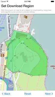
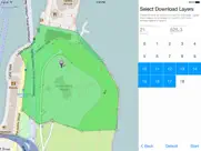
● Configuring, viewing and downloading any online maps of XYZ/WMS/WMTS patterns, or using scripts to configure more complex ones.
● Handling GIS vector file formats, such as Shape(SHP), TAB, GEOJSON, GML/GZ, AutoCAD DXF...
● Handling Common GIS file formats such as KML, KMZ, GPX, CSV, WPT.. Supported styles in KML/KMZ.
● Handling offline map file formats such as MBTiles, RMaps...
● On-map vector editing with finger drag-drop and magnetic snap.
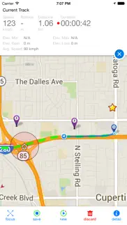
● GPS Track Recording with auto-recovery and background mode support.
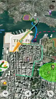
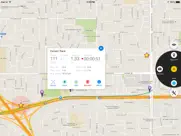
● Path Following with voice guidance for both user paths and searched direction routes.
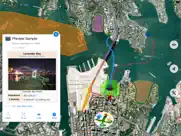
● Displaying locations of photos and videos in your system photo albums. (no need to import)
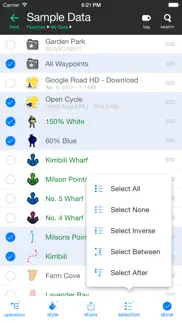
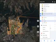
● User data management with folders, sub-folders, layers, bulk operations, shortcuts, tags and fuzzy searches. Supports Advanced Search by using expressions with attribute conditions.
● Using Feature Class for bulk editing and managing similar (same class of) features and layers all together. Supports bulk Attributes Merge and Link Relationship Building between features of different classes.
● Conditional Style and Expression provide dynamic content rendering.
● Customizable pop-up panel for on-map picking items with HTML, JS and CSS support to make custom forms, layout and rich-formatted content.
● Handling coordinates in MGRS, UTM, and Plus Code.
● Photo Markup allows you draw markups on photo, such as arrows, texts, free-hand drawings.
● Browser Access allows you to access app's data or files from a desktop PC/Mac with a web browser wirelessly.
● Sharing or transferring data via Wi-Fi, Bluetooth, iCloud, SMS, Email, QR codes, Open-In, AirDrop or many other ways.
● Many more fantastic and free functions could not be fully descriped here, such as Guide Mark, Arrival Notification, Photo Mode, Map Level Adjust, Custom Icons, Photo/Video Attachments, Image Overlay, Text Overlay, Fast Editing, Distance/Perimeter/Area Measuring, Custom Time Zone, etc.
User Manual:
https://duweis.com/en/mapplus_guide.html
User Forum:
https://duweis.com/forums/viewforum.php?f=13
Contact Us:
support@duweis.com
😍 Do you love Map Plus app? Please share your friends!

Please wait! Map Plus app comments loading...
Map Plus 2.9.0 Tips, Tricks, Cheats and Rules
What do you think of the Map Plus app? Can you share your complaints, experiences, or thoughts about the application with Miocool Inc. and other users?
Map Plus 2.9.0 Apps Screenshots & Images
Map Plus iphone, ipad, apple watch and apple tv screenshot images, pictures.
| Language | English |
| Price | Free |
| Adult Rating | 4+ years and older |
| Current Version | 2.9.0 |
| Play Store | com.finwer.MapPlus |
| Compatibility | iOS 12.0 or later |
Map Plus (Versiyon 2.9.0) Install & Download
The application Map Plus was published in the category Navigation on 27 May 2011, Friday and was developed by Miocool Inc. [Developer ID: 438868203]. This program file size is 39 MB. This app has been rated by 552 users and has a rating of 4.6 out of 5. Map Plus - Navigation app posted on 16 April 2024, Tuesday current version is 2.9.0 and works well on iOS 12.0 and higher versions. Google Play ID: com.finwer.MapPlus. Languages supported by the app:
EN ZH ZH Download & Install Now!| App Name | Score | Comments | Price |
- Layers support dynamically changing their "Selectable" options by conditional styles from the feature class. - New setting option of "Edit Track After Saved". - Supports more sorting methods in data and search result listing. - Adds new JavaScript functions of "Title()", "Subtitle()" and "Q(selector, value)". - Support editing titles and subtitles from HTML notes with a new URL scheme. - Supports "Simple Info Panel" option for on-map popup info panel to be displayed neatly without title and subtitle. - Other bug fixes.
| App Name | Released |
| Parking.com - Find Parking Now | 07 August 2018 |
| NAVER Map, Navigation | 01 May 2009 |
| Find My Friends Phone - iMapp | 26 July 2014 |
| Volta Charging | 11 June 2015 |
| Neshan Map | 04 May 2023 |
Find on this site the customer service details of Map Plus. Besides contact details, the page also offers a brief overview of the digital toy company.
| App Name | Released |
| CDOT Colorado Road Conditions | 21 October 2020 |
| Light Pollution Map | 20 September 2020 |
| Jacksonville Zoo - ZooMap | 25 October 2021 |
| NavRules | 07 March 2011 |
| Blitzer.de PRO | 03 August 2022 |
Discover how specific cryptocurrencies work — and get a bit of each crypto to try out for yourself. Coinbase is the easiest place to buy and sell cryptocurrency. Sign up and get started today.
| App Name | Released |
| WhatsApp Messenger | 03 May 2009 |
| DoorDash - Food Delivery | 10 October 2013 |
| Target | 24 November 2008 |
| Amazon Shopping | 03 December 2008 |
| Cash App | 16 October 2013 |
Looking for comprehensive training in Google Analytics 4? We've compiled the top paid and free GA4 courses available in 2024.
| App Name | Released |
| Monash FODMAP Diet | 17 December 2012 |
| Suika Game-Aladdin X | 06 March 2024 |
| AutoSleep Track Sleep on Watch | 19 December 2016 |
| Paprika Recipe Manager 3 | 15 November 2017 |
| True Skate | 18 October 2012 |
Each capsule is packed with pure, high-potency nootropic nutrients. No pointless additives. Just 100% natural brainpower. Third-party tested and validated by the Clean Label Project.
Adsterra is the most preferred ad network for those looking for an alternative to AdSense. Adsterra is the ideal choice for new sites with low daily traffic. In order to advertise on the site in Adsterra, like other ad networks, a certain traffic limit, domain age, etc. is required. There are no strict rules.
The easy, affordable way to create your professional portfolio website, store, blog & client galleries. No coding needed. Try free now.
Map Plus Comments & Reviews 2024
We transfer money over €4 billion every month. We enable individual and business accounts to save 4 million Euros on bank transfer fees. Want to send free money abroad or transfer money abroad for free? Free international money transfer!
It does it all. I upgraded and it's worth every penny. Import and export no problem. Tracks and points no problem. Tons of customization. As someone what said there's a learning curve and clearly labeled buttons would fix that but alas it's 2018 and clearly labeled buttons are out of fashion every where.
Perfect app for pipeline work. This app is perfect for anything I’m doing out in the field all across the country and it never fails me. Easy to personalize my map files just got I want them to make work easy for me.
Need service. Sometimes it’s slow to update when running the outlaws
Love this App!. New to mapping. I work for a small utility and we are using it to map our sewer system. Easy to use. Easy to create kml files and use in other applications.
Ecxellent App. I have been my geological activities whit this app,you can take any usual format and convert your data. this app is very good for produce geological maps. Thank you
Does not Include a tilt-pan view.. Does not Include a tilt-pan view while locked onto my live-location. I’m certain that every map app on iOS except for google maps and ways, does not include a tilt-pan, one of the most critical elements of what makes a gps map awesome other than graphical resolution. I would greatly appreciate it if you could include a tilt-pan at the same altitude of distances that google maps provides.
Crashes every time. I use this app for work a lot. As of recent, anytime I open the app with a KMZ file it freezes, then crashes. This is happening on a brand new IPad, and IPhone. When this app worked I loved it. But about to switch back to google earth if this isn’t fixed.
Best App for Map Geeks. I’m a GIS professional and use this all the time instead of ESRI tools. Offline maps from any raster source is invaluable.
Version update removed custom map layer functionality. This was a great app because I could use all my tiled and georeferenced map layers for underwater topography and see what the bottom looked like as I was cruising over it. But with this latest update in IOS they have removed this functionality rendering it useless for me now. It is now no different from other mapping apps. Please bring back the map layer functionality.
I’m not the typical user and STILL find the app awesome.. Before running out to a store to buy an “old” paper map to draw on and mark-up, I figured I’d check in the AppStore to see what kinds of maps were available to be marked up with unlimited “pins” and locations. After downloading a few apps and quickly becoming disappointed with them, and thus deleting them from my phone, I was leaning towards going with the “old” paper map purchase. I came across this app and wasn’t expecting much for what I wanted to use it for, which was the placing of unlimited travel destination “pins” all over the world, I downloaded it because it was free. I quickly came to the realization of how powerful this app is and decided to purchase the full-featured app, justifying the cost as being similar for the paper map idea I had. I have no clue of what most of the tools do, but for my purposes, this is absolutely perfect. Thank you for this open-ended map!!
Great for marking off areas on maps. Very impressed with this app. We’re able to mark off areas on maps. Great alternative to Zeemaps. Recommended must have for any company that canvasses.
THE best mapping application. This is by far the BEST mapping program out there. I was sad to see it had not received any updates (and the company behind it disbanded). however when I saw a fresh update for it, I was able to STOP my hunt for a replacement. (NO other application even comes CLOSE) I use it to map out a large newspaper delivery route. 300 custom pins and tracks, and it doesnt even bat an eye. volume of pins that makes all other programs crash. IF this went to subscription based I would gladly pay, as it would be worth it to me for such an incredible tool.
Multiple use. Ability to measure, draw lines, areas, and follow position and create trails... almost perfect. Now if it could better utilize external gps like Bad Elf, it would be perfect.
What in the holy little gem is this. Maybe this is a niche app for specific people but holy cow this app is great. The UI and programming is top notch. I use this as a military aviator to make overlays that I can import at KMZ and KML files you other apps. It’s seamless. I can think of tons of other ways to import and use it as well. This is a steal at a $20 one time fee.
A flexible, convenient, reliable map!. Easy import/export trips. Require some learning curve then a convenient tool is ready for use. Tag system helps organize different kind of trips and waypoints greatly. Good job!
House search layers map. I moved to a new area. I wanted to buy a house so I made a map with layers from public maps that included flooding, hillside instability and earthquakes, apartment locations, and crime reports for the last five years. I use the Realestate app Redfin to notify me of houses per my specifications, and then I would look at them on my map to see any major problems. Very easy, very good app.
Work nicely. Only issue I had was changing default drop pin type/color for subsequent drops so had to specify each time. This could have been lack of experience with the app.
Wow. This is an absolutely incredible app. There is so much to it, yet it is still easy to understand. It can be a bit finicky at times, but it almost always is perfect. I used it to map out four wheeler trails around my house, and it did the job, and did it well. Would absolutely recommend. Something that I would like to see would be more unique built in icon options.
Crammed full of features. After an exhaustive search for a map app with all the features I needed, I stumbled across Map Plus on a fluke. And boy am I glad! This app has more features than than you can shake a stick at. As I stared adding points, at every turn I found my wishes granted. It’s crazy how many options the developer thought to add. My mapping app search has ended. I’m in love.
useful & reliable. I've been using this on my farm to design & manage a grazing paddock system. I like that I can import drawings from Google Earth & then with this app I can see where I am as I physically walk my design on the land with my phone. It took a bit of experimenting to figure out the functions, but I chalk that up more to my own GIS-newbie status. Glad to have found this, thanks!
Pipeline operators input. I absolutely love this app I use it to import our ARCGIS files it’s far more intuitive than ESERI if I could it would have 10 stars. Easy to update and add special characters.
Great app for creating .kml files. I use this app a lot to create .kml overlays for another app called ForeFlight. It work very well and is easy to use.
Love the app for outdoors use. I’ve been using this app for years to hold and display maps and date for my outdoors activities. I can hold and select numerous maps within the app and keep all the track data needed in shape files. I paid more for this than any app before and have more than gotten my money’s worth.
Like it a lot so far. Good app so far. Interface takes a little bit getting used to. Does everything I need it to do.
iOS 13.1.2. With the latest iOS 13.1.2 taking pictures of signs for sign inventory repairs from hurricane michael, the app, when holding the phone upright and taking a picture, the app automatically saves it turned sideways. The only way to take a picture of a sign upright is to hold the phone sideways to get an up and down picture. I am saving and sending in kmz format, which is what Florida DOT wants. Please fix, or don’t update iOS to the latest version, because the app becomes a mess to manage data. Please fix ASAP
Great app but takes some time to learn the interface. I was looking for an off line version of google maps that I could still draw on while off line. This app does it all. I use this for hinting and hiking. I love the fact that you ca also track your route as you go which is a bonus as google can’t do it. Their “no network needed” file transfer from phone to phone is great. Allow you to collaborate data collected without finding cell service first. The only upgrade I can think of would be to see your invited friends on the map when you have a data connection. Maybe establish the link when connecting wirelessly?
Site work. I just tried out this app with a overlay of a excavation site , I’m impressed how well this app works . I’m a GPS supervisor for a excavation company that uses gps dozers for location and grade control and this app should allow project managers and owner to come on site and know exactly where the machines are working as they drive through site . The thing I would like to see with app , is that the screen moves in same direction is you travel . Maybe it already has this feature ,but I could not find in settings . As I said I’m new to this app , still learning what it can and cannot do .
Great For Aviation. Love the ability to load shape files, kmzs, and edit labels. You can even load aviation maps as a background.
If you don’t have it, you need it !!. Awesome app to keep track of your driving
Get it!. Are you a surveyor? Do you like to do off routing in the woods with no idea where you’re going? Never have a problem finding your way back? It’s not a Google map. It has limited destination abilities. But you can create your own maps. Import them to Google maps and mail them to friends.(provided you have signal in the woods). My favorite is the ability to track my path and be able to follow it back digitally. Digital breadcrumbs and it’s fairly accurate. 👍🏻👍🏻
Powerful and well designed. I test apps for a living and I’m a GIS professional. This app kept me engaged for hours building layers and changing thematics.
Mind Blown. So happy with this app, you don’t have to be a coder to manipulate map files with this app! I have used it many times for aerial applications and it’s just been a pleasure to use. If I had one request, it would be to have a searchable help menu in app. Keep up the great work!
Happy Geologist. I use this app principally to view georeferenced maps while out mapping in the field and can easily overlay Topo and geo maps, and while using my built in GPS unit on my IPad can precisely locate myself. Overall a great map for dropping pin locations and attach photos such that they are GPS referenced. However, my only complaint is the line drawing functionality. If developers could add a line drawing function that is more organic, such as using your finger to draw the line, that’d be a great add. If better line drawing functionality would be incorporated, it would make it such a great mapping app. As it stands, it is a great tool if you have referenced maps to use in the field or trying to plan transects without lugging around numerous paper maps.
I’ve tried a ton of map apps and none come close to this.. I’ve tried a ton of map apps and none come close to this. It’s easy to use and very thorough!
Excellent App. This has become my “go-to” app for GPS and portable GIS work. Powerful, accurate, and well-designed. Ability to import garmin custom maps especially useful. And the developers are VERY HELPFUL and respond QUICKLY to questions.
Great!. I'm a rural postal carrier. Use this app to record new routes I learn so it's easier for me to do them on my own. Some are over 100 miles weaving around gravel country roads and this app works great!
Great app. Love this app. I use it for hunting and scouting. My only issue is I can not get the satellite map overlay to work. It would be huge if that feature worked properly. It pops on then goes back to a blank background. Any help would be appreciated. Other than that I'd give it 5 stars.
Only missing CarPlay. I’ve used this app for several years with pins dropped for oil and gas locations, and it works great. It’s easy to share with other users, easy to edit, and makes navigation of unfamiliar areas a lot easier, all that being said I would love to see CarPlay feature like google maps/Apple Maps/ Waze, so when you plug phone into vehicle the info would be displayed on vehicle screen instead of having to use my iPad. I’m sure there are other users that would agree
Great for minor GIS work. Would be even better if you had the ability to print GEO referenced maps.
Maps plus. A couple friends and I use this app for UTV riding. We love the app. I like the fact I can export kmz files to put on Google earth. I would like to see them add a route planning feature. Another app I use has this and it works great. The other app is not near as nice as this though.
Perfect. I helicopter hunt various properties that I must stay within the boundaries of the Ranch. I’m able to import google earth files and see where I am and track where I’ve been plus more. This app works better than the Avation navigation systems in the helicopter. They nailed it!
Really solid app. There are a few user-interface that could be improved, but overall, the functionality is great, I haven’t run into any bugs, and the bang:buck ratio is awesome. I use this primarily for work in water resources and civil/environmental engineering for some basic field survey work and retrofit inventories. Arc Collector is another tool to use IF you have the ArcGIS subscription ($$$$$), but this will work nicely with many free software programs such as Google Earth, QGIS, etc. Highly recommended.
Clean and Powerful. I am just starting to navigate my way around all the tools within the app. As a Google Maps user is was difficult to figure out the layering and editing tools in Maps Plus. The OIS based map is so much cleaner than the Google Maps which has all the commercial clutter visible. Maps Plus (full feature) just has so many custom editing tools that allow me to add much information in a visually pleasing way. The record option is my favorite for creating a directional map that is not the standard Point A address to Point B address. I can now just record my travel thru commercial areas, parking lots, shortcuts etc. I haven’t found a way to keep the app in Edit Mode. I have to toggle back on after each “saved” edit. A little annoying. The biggest draw back is the lack of a tutorial on how to create simple layers that have different features visible on demand. Everything seems to be in a folder system that is a little cumbersome. It would be great to have an option to have all folders open and be able to drag edits to desired folder and be able to one click on visibility of everything in that folder. I’ve been looking for a mapping tool like this for years. GREAT APP!!
No words. I have never done anything remotely like this before.... I spent over a year to plot almost 958,000 data points. I didn’t know a tick mark from a waymarker, or the difference between them other than as words. It was challenging it was hard,I was confused by KMl, KMZ, HTML. Zip, Ziip. MML. JSON Literally pulling my hair out by the end of it. And I downloaded this not even knowing a fraction of what it could possibly do. And let me tell you those 980,000 points looked terrible after a whole year with this app I had that plot it out with different layers with track marks in one layer white point on another point markers and one debility to combine them or separate them. This app is freaking incredible
Great app for SXS riding.. Downloaded this for the Hatfield and McCoy trails. Imported maps from someone who has been tracking the trails for years. Loved everything about the app while I was on my trip. The only issue I’ve run into is figuring out how to update new map packs in to replace items that changed on the old one. Still learning some of the ins and outs of the app but I still highly recommend it.
Great app. Love it. Have used for several years. I imported an accurate map of our riding area obtained from US forestry service. Now all of my friends want to use my phone to see where we are on the forestry map. J D
Definitely worth every penny. This mapping software is extremely capable however the export file it creates doesn’t seem to import into my Google earth.
House numbers. Full paid version: Many great features, I cannot figure out how to manipulate the map to see house numbers, I do not reject changing any settings. Any suggestions pls 👍 extremely helpful feature for my job.
Very good app. I use this app very often to work on the field. The functionalities are very good, taking pictures, recording tracks with the ability to export to google earth. The only thing I found it difficult is to import maps to use while offline. The tutorials for importing offline maps are not good.
Excellent application. I have been using it for 3 years now and it has been of great help to send drawings made on google earth to then locate those lines on the field while looking at the location on the phone. That helps tracing roads and fences.
Did you know that you can earn 25 USD from our site just by registering? Get $25 for free by joining Payoneer!
Costly updates. I was originally fairly happy with the app and purchased it some time ago with all the major enhancements available at the time. I now find with a recent up date they have added another in-app purchase for "full function" which is really expensive and is what I thought I had before this update arrived. I would suggest looking elsewhere.
Excellent. Fantastic GIS app. User friendly controls, flexible and has attributes for objects. Great survey tool
Outdated Maps. Just viewed my local area and the satellite imagery is outdated by a few years.
Excellent. Better than expected. Clear delineation of features and works well with IPad mini
Amazing app. I use this app regularly for work in the precision ag sector and for my own personal use building marine charts and various other maps. Can’t speak highly enough of the app or the support team and the development team.
Awesome App. Let’s me take my maps into the field in the middle of nowhere and is deadly accurate.
What A Great Surprise. I discovered Map Plus by chance, looking for an app to read MBTiles. It amazes me how easily this app handles nearly all mapping tasks. Whether online maps or offline maps, Map Plus handles them with ease. Online Help files are comprehensive - a PDF version would be welcomed.
Useful. Quite useful if your in china and if your lost :)
Amazing quality. Was looking for a replacement to MotionX - this one ticks all the boxes, plus it’s elegant and slick. And NO subscription 👏. Highly recommended and simply all-round stunning!
Amazing and useful. A spectacular app that utilises every feature of digital mapping to make mapping out a trip or implementing datasets easy and intuitive.
Useful free GPS app. Maps plus is a competent gps app with good track and waypoint management and reasonable online maps while you are in range of a phone tower. I’d rate it higher if it had better online map caching. It has the unpleasant feature of dropping maps for no good reason when you loose data connection. It also obscures tracks and waypoints from saved or kml files which makes the app pretty useless at those times. Maybe this is only in the free version. But it does not inspire me to pay for the in app purchases.
Brilliantly simple. Simply brilliant.. I use this app on my iPad with a Bluetooth gps in remote central and northern Australia. I’ve been caught out only once not caching relevant satellite image data before operating without phone reception. I have hundreds of remote monitoring sites stored, some on tracks, some not. Collecting photo references is easy although as far as I can tell it’s only one photo per point. It’s straightforward to file, search and edit data within the app and to import/export. The help file/manual is useful. If there was a subscription I’d pay it.
Gets better. This powerful little app keeps getting better and better. It does all the tasks a field GIS needs to do. Now with the ability to import .DXF it is a powerful tool for civil project management in the field. Very good value for money, and prompt support for any reported bugs and queries.
Great app!. This app has helped us tremendously, sped up field work, and because it is so easy is used more often. Great work, keep it up!
Great for 4WD. I use this app to navigate around off-road. You can import heaps of maps and aerial photographs from external sources, digitise tracks, waypoints, take photos on route and export to Google Earth. Has everything you need.
Good, but no major differentiator. What it does it does well, but no sneaking around the edges, imagine if it had NMEA over tcp? Then I could connect my non Bluetooth RTK gps to it like I can to the nautical charting apps. Come on lift your game!
Track work. I tested the app and was impressed by its capability, but I found it was inconsistent in being able to track my position. I need this in my profession. If this can be improved it will be great.
Cool app. Great app. Search, pass all you need. Good cycle map
Best GIS app ever. This app is so powerful. Very good product that just keeps getting better! The developers are so helpful and quick to respond. Out of all the mobile GIS solutions I have used over the last 8 years, Map Plus is by far the best. Many thanks
Family Share doesn’t work. Great app, does what it says on the box. Mostly accurate. Minimal bugs and glitches. Loses a star for, at such a high price, not having the ability to family share the app. Extremely disappointing.
Nice app. Improvements could be audible alert when approaching a point in a dataset. Simple Labels on data. Good and getting better. B
Imagine you at your best. All the time. Picture yourself at your sharpest and most productive. Your most alert and focused. Your most lucid, creative and confident. At work. At play. In every area of your life. Add Mind Lab Pro® v4.0 to your daily routine and uncap your true potential. Buy Now!
Better then google maps for KML. Very simple and clean. Really good app with impressive options.
最好的软件. 不用终身遗憾。
Excellent. Excellent, precise , stable, with several useful features. Thank you for developping such a useful app.
Needs Work. This is arobust map editor with a lot of flexibility. But it needs work on simplifying the user interface and data management system. Often you needd to click many times deep into menus to get at something. Also, it uses Settings for too many in-app processes that should have their own dedicated controls. The save and share functions are not easy to figure out, and it is not intuitive how to keep a map with its objects into a single file or folder. Other than those areas of improvement the app is a solid effort at map management and editing. Wotk needs to be done but I reccomend this as more of a work in progress app than a professional finished product. The developer has been very supportive and engaged.
Works great. Some minor issues when changing waypoint info and the updated info doesn’t always show up on the map data but very good app for waypoint managing. Only app in the App Store that I’ve found that will meet all of my requirements.
Displays kmz files!!. I just need an app for hiking that saves maps for offline use and displays kmz files (with custom colors and icons). It does both perfectly!
So far one of the best sources I’ve used. For higher definition imagery, seems most of the available apps here are misleading and a waste of time
Nothing like it. Its perfect.. I work on an industrial green field mine construction site and this is the absolute most perfect tool for site tours, witness & holds, and general coordination with contractors. I highly recommend this for construction projects.
Best GIS app for iOS. Map Plus is a pleasure to use, and chock full of so many great features.
Crashes. Works well but when too much data is loaded it crashes. Can’t use the full capabilities.
Offline MbTiles Map Support, and More. Easy to use. Open MbTiles map directly from email. Love the user interface. Bravo!
Favourite mapping app for backcountry. Love the whole app — it wasn’t long before I supported this project and upgraded to full capabilities. Map Plus is chocked full of every feature needed to build personal custom offline backcountry maps for quadding, paddling, hiking, exploring, whatever. There is no other app as fully featured that doesn’t require a user account and community subscription to all this stuff you don’t need. If you are willing to get a bit technical (read documentation to get an idea of capabilities) and simply want a GIS solution to work on your maps, routes and POIs in detail with offline access, use Map Plus. Using MOBAC on my laptop, I’ve been able to start assembling and downloading offline satellite maps at selected zoom levels of my area. I can also import route and POI data from my GPS device or track locally in app. Later I can split and modify all tracks, waypoints, POIs etc, to help me find places later or even get back home in the dark. Ability to import and export everything is so lovely, setting are detailed leaving nothing out. A huge shout out to developers for making this app, it’s simply the best.
Map Plus. This app works quite well, accuracy is slightly off, it would be nice to be able to plot a route, big bonus is you do not need to be connected to wi fi!
Work perfectly!. do what it is supposed to do
good job. support kml file easily !!
Not perfect, but best iOS GIS Mapping Software. Still the best iOS Professional GIS mapping software by far. Have used for years in professional work, the most stable, dependable, useable and efficient professional mapping tool for ios. I would like to have forum support back, as there was a lot of good information there.
Powerful tool. Amazed by features and power of this app. Makes my life so much easier and I can impress co-workers too.
Excellent GPS App!. I used this app for my road trip around Vietnam. It supports KML files and it has been a wonderful tool to help navigate during this trip. I highly recommend this!
Meilleur appli. Très bonne compatibilité avec des programmes GIS Facile d’utilisation plus de 5ans d’utilisation. Bravo bon travail! Dom.
Best Mapping software for iOS. I have been using this software for years for offline mapping. I love the ability to add different online map URLS to get customer layers as well as the function to change transparency and use multiple map layers at the same time.
Adsterra is the most preferred ad network for those looking for an alternative to AdSense. Adsterra is the ideal choice for new sites with low daily traffic. In order to advertise on the site in Adsterra, like other ad networks, a certain traffic limit, domain age, etc. is required. There are no strict rules. Sign up!
Really good gps app. Well, I like trying and deleting lots of gps apps. This one remained and I paid for full version, also. It means I was convinced that has real value. One small observation - I think it is a bit difficult to find and start the recording. Maybe developer could introduce taking photos/videos along the route recording? Anyway, thanks and good luck
Extremely Pleased. I do a lot of field work in an agricultural setting where fields (marked by shapefiles) are widespread and numerous. I take notes and photos and link them with the grower specific field. Map Plus has been invaluable and easy to use!!
This app is a scam!!!. After purchasing Enhanced Formats option in the app I still can't export in KML format (KML doesn't appear as an option). I restarted the app and the phone. If I don't hear from the developer in the next couple of days I will report it to Apple and request refund. I will update this review if I hear from Miocool.
Accesses clipboard on launch.. Since iOS 14, it’s become apparent the app is accessing the clipboard oldies activated. It would be nice to have it fixed, or at least have an option to turn off this potential invasion of privacy.
Best GIS app available!. Compatible with several GIS file formats. Don't need to use iTunes to transfer files. Many, many options-- have been able to do everything I've needed to do! And it's FREE!! Try this app first, before shelling out the cash for others.
No instructions. Might be powerful but absolutely worthless without instructions or support. The only thing it seems to be good at is stealing my money
Awesome app!. I have gone through many mapping apps through the years in managing my newspaper delivery routes of 300+ pins and each one had one or two features I needed but never all of them in one app (track recording, pin management, or custom icons) Then I found this app which does everything I need it to and more. I'm always learning something new I can do with this wonderful app. WELL worth the price, and you can enable only the features you need. BONUS points because you can edit the track right from the app!
I love it!. It is a professional app, so I cannot recommend it for ordinary users. The satellite image is better that google map in my area. I have to retrieve the satellite map each time, and it is a bit annoying since internet is poor in remote areas that we basically gonna do a geo related work. I am a user of QGIS so I used to exchange files between my iPhone and MacBook. In this case, I have to email my surveys to myself because if I share directly, it sends as an image not a vector. At least I could not find a way.
Best GIS app around. PERIOD.. This thing is by FAR the best GIS app I have used to date. Its chock-full of features and just plain works. There is a lot going so the UI can feel overwhelming at times, but all in all it blows all other apps out of the water.
Awesome for GIS. all of the apps that are out there are too hard to operate and cost a lot. this app is simple and very straight forward.
Offline satellite. Exactly what I needed. Perfect for offline maps and gps where phone signal is none. Also able to import kml files. Don't mind ads when it works like this app does
MAP PLUS. I have been impressed with map plus I absolutely love it. It has help me a lot with the job that requires a lot of map info and a lot of data input. Thank you I have recommended map plus to everybody I work with.
Best gis app for ios. The most feature rich app I have ever seen available for IOS. Supports data fields for all features and kml extended data tags, as well as styling classes that can be applied to multiple features. Great measuring tools. Line creation could be better as it just drops lines and then you have to modify them to your fit. But overall very very cool.
Put previously free functions behind pay wall. I was happily using the free version of this app until today when I found that when I wanted to export the files to google earth the option to download them as KML/KMZs was put behind a paywall where they used to allow me to do this for free. That's a very underhanded and sneaky move Map Plus, because now my data is being held ransom, where I might have paid for a privilege I never had, I'm not willing to pay for something that was previously free.
Why can’t used with iOS 13.6. Dear Sir and Madam, I would like to tell u I always bought Licence Map plus from your product, but when I updated iOS 10 to 13.6 I can’t used it why? I hope that response from you & ASAP. Thank & regard
Happy veteran GIS User. I've used numerous GIS tools over the past ten years and found this app to be far superior than most, for what I need (market/feasibility analysis). It allows me to import several layers without clogging up my memory/storage (via iCoud). I hope to see this around for a long time!
Great UI for building shape layers. I do photogrammetry with UAVs and having a good shape layer editor is crucial for post-editing I've tried ~10-15 mapping apps and this is the easiest, most-feature-packed one by far. The in-app upgrade is well worth the money - wish I would've found this before wasting my money on other mapping apps.
Better than apple map. It was amazing when i found it as good as google map even better in ios 5, unfortunately when i updated my iphone to ios 6, i found a non applicable map on it, i was disappointed from apple for this terrible map, but a friend suggested me that use this good app instead apple map, i would like to appreciate for this free and useful app, many thanks.
Great Map App!. I have tried dozens of mapping apps and this one is a keeper. Many apps make you pay up front just to try them out. This one is a free download and then you can purchase the features you want. It also does a great job processing and displaying KMZ files produced from the desktop version of Google Earth. Customer service is also outstanding. Five stars!
Great app. Very useful. This is best one I found so far.
This app seem pretty good, but. This app seem pretty good. It looks like it has the features that I'm looking for. But unfortunately, it keep freezing on me so I cannot fully try it out. As soon as I start the gps and pinch the screen, it locks up. It also locks up on other occasions. If you can get it to stop freezing, I may give it 5 stars. I'm using the latest iOS, on a 5S.
Great app. Ideal for taking farm info to fields, and keep records works great also without cellphone signal.
Even better than "Swissknife". Last two weeks, I have been tried this App. As GIS expert and senior cartographer I appreciate software capabilities and strongly suggest for everyone to use it for daily and pro needs. Congrats for dev. Team.
DO NOT USE THE DIRECTIONS. This app reports the wrong coordinates to google maps and Apple Maps. It’ll take you in the complete wrong direction.
Unbelievably awesome. This is a great app for geological, forestry, or any kind of field work. This new update allows me to make easy waypoints with a press and swipe. I can very easily upload my work KMLs and reference them in the field. Everyone wants to know what program I'm using to get from site to site. I can quickly measure areas and distances. It's just really exactly what I need, that Google Earth simply does not provide, as of yet. Thanks for making this app! I paid to remove ads and it is definitely worth it.
Great tool for navigation and mapping. This is the best gis capable mapping app for at least a couple years running
Best gis app on ios. The most usefull apps for gis,, would be very usefull if table editing feature is added,,
Map plus. Verry good app
Best offline map performance. I have several gis/gps apps and Maps Plus offers the best off line aerial photo map performance of them all. I am out of cell range very often and rely on the ability to download aerial maps with roads and other features. Importing shapefiles is easy and the performance is great.
Amazing app!!. I have used this app for a long time and just love it. The only suggestion and one that I really need is the ability to set a reminder to a pin. I use it for work to manage my clients and it would be so nice to just assign a due date and time and get reminded about my appointment with that client. Please bring this functionality to the app. Thank you very much.
Great app. Very easy to use and extremely useful when offline, especially when you lost your way in a remote area. It could be life saving app in some situations . The tech support is extremely knowledgable and quick, beyond my expectation. My only suggestion is to improve the enhanced map downloading speed.
Custom map server!. While the UI may not be as intuitive as I'd like, the fact that you can use custom mapservers for base maps, overlay kml/kmz files, and save for offline use makes up for that. Powerful app that requires a bit of GIS know how.
It works pretty well. It is a very functional gps app, and it is able to display offline maps. So you can take any map with u. Hope in the next version more online maps source will be added.
The Best. Tried several map apps. My need is to be able to open a Google Earth satellite map with my icons and names visible when I dont have a wifi or cellular connection. (Fishing in remote area). This is the only app Ive found that does this and does it well. Edit function needs some improvement but overall this is the nr 1 app for this use.
Difficult to read. Very difficult to read.
Perfect. This is exactly what I needed, please don't ever delete this app
Would be a good app if it didn't constant lockup. The app has great features like photo geo location and route planning on top of saving bandwidth to display a map - HOWEVER - one of the reasons I wanted it was to route between two points in Hong Kong where the cabs can be quite shifty, the app locks up and crashes every single time you try to use location with routes! It also locks up fairly often with location alone - making a map application without the ability to do simple location pretty much makes the app useless! If they could fix these bugs I would change my review to be very good. For now, don't waste your money!
Amazing. This map app is amazing for custom points/paths, offline maps, and just general ease of use. The interface is extremely slick, professional, and intuitive. I'm honestly surprised this isn't THE go to app for custom map data, it is phenomenal and the price is right!
Great for offline use and with kml files.. I use this app practically all day, especially with kml files that I've imported. We're talking big kmls, layers that slow google earth to a crawl on my desktop. So kudos for that and the decent offline map support. A few suggestions, though: A color inversion function for night. This is badly needed, although it might be implemented already but buried. Second, I'd like to be able to decide when/if the screen times out (basically, never when it's plugged in).
Simply the Best. This is seriously one of the best apps that I've ever downloaded. It's of simple design, easy to use, and supports file exports that no one else comes close to offering. Absolutely no regrets and seriously worth the in app purchases. I had to figure out the best way to get the KML onto my computer. If you've bought the capability, go to the file, tap share, choose documents, then plug in your phone to your computer, open iTunes, open up your the phones apps tab, scroll down, and you should see a little box of the files you want to take out.
Finally!. This is the type if GIS app I wanted for my iPad for a couple years now. Glad I found it. Am able to tinker using it free, but the paid features have strong appeal.
Best english map for China. I'm am american living in China. This app is brilliant. Record tracks and waypoints. Download areas for offline use. Its the very best map i've found for iphone. Many many features.
Great app for geologists but lacking in one key area. This is, overall, a great app for geologists and could be nearly ideal with a small change: -- allow us to draw freehand paths and polygons, especially useful for those of us lucky enough to have an iPad Pro and Apple Pencil. The current method of entering paths and polygons is so tedious and clunky that it discourages entry of all but the simplest shapes and paths. Complex fault traces or formation boundaries are just not feasible, sadly.
Upgrade fail. Maps don’t load yellow screen instead.
Works great. Way better than google earth
Offroader and camper. Very good app exactly what i want The only problem is you don't have exporting option to other app inside iOS Please add that future because in the middle of desert we don't have wifi to share with email!!!!!!
New update. The new update messed up everything that was coded in with the custom properties and conditional styles. My app is only showing orange lines and not what I have placed. No response for helping to resolve this issue with the new update
Russian Map Plus?. Russian language app also called ”Map Plus” showed up on my phone. What’s that about?
Works, but clunky. Cannot open loc in Apple/Google maps app.. Very powerful app, however the interface is a bit clunky and there is NO WAY to open a location in either the Apple maps or Google maps app. This is extremely necessary since it seems the public transit directions don’t work in this app.
Bad. App crashed my phone. I can’t believe that it’s a new iPhone XR