GIS Kit App Reviews
GIS Kit App Description & Overview
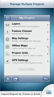
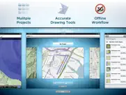
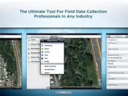
What is gis kit app? Premier field collection and data viewer for iPhone and iPad.
- No desktop GIS software required.
- No prior GIS training required.
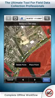
- Completely offline capable.
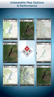
- Cache (download) open source topographic maps, street maps and satellite imagery straight from device.
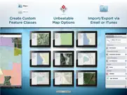
- Import ESRI Shapefiles and KML/KMZ files including attributes.
- Attribute fields include: Alphanumeric (Description), Photos, numerical values, user defined list of values, addresses, websites, date & time, telephone number, check box.
- Easily collect new point, line, and polygon features in the field by GPS or drawing manually.
- Enter attribute values for each feature and/or add new attribute types at time of collection.
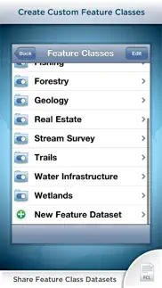
- Create templates of user defined feature classes with custom attributes.
- Comes loaded with numerous example feature templates for professional use in Forestry, Wetland Delineation, Stream Surveys, and Real Estate.
- Import and export data wirelessly by email. Larger data sets can be imported/exported by connecting to any computer with itunes.
- Organize by projects and layers
- Best-in-class performance.
Check our website to see videos, documentation and more information about the "Pro" version. Please note that all the features of the GIS Pro version (such as Shapefile export) are available through in-app purchase in this app as well.
For Businesses:
Please note that a separate license is required for each user or each device that is used by multiple users. See http://www.apple.com/legal/itunes/us/terms.html for details. Also see http://www.apple.com/business/vpp for information on purchasing in volume.
Continued use of GPS running in the background can dramatically decrease battery life.
😍 Do you love GIS Kit app? Please share your friends!

Please wait! GIS Kit app comments loading...
GIS Kit 3.31 Tips, Tricks, Cheats and Rules
What do you think of the GIS Kit app? Can you share your complaints, experiences, or thoughts about the application with Garafa, LLC and other users?
GIS Kit 3.31 Apps Screenshots & Images
GIS Kit iphone, ipad, apple watch and apple tv screenshot images, pictures.
| Language | English |
| Price | $99.99 |
| Adult Rating | 4+ years and older |
| Current Version | 3.31 |
| Play Store | com.garafa.GIS |
| Compatibility | iOS 9.0 or later |
GIS Kit (Versiyon 3.31) Install & Download
The application GIS Kit was published in the category Navigation on 05 August 2011, Friday and was developed by Garafa, LLC [Developer ID: 284829377]. This program file size is 43.6 MB. This app has been rated by 12 users and has a rating of 4.0 out of 5. GIS Kit - Navigation app posted on 19 November 2019, Tuesday current version is 3.31 and works well on iOS 9.0 and higher versions. Google Play ID: com.garafa.GIS. Languages supported by the app:
EN ES ZH Download & Install Now!| App Name | Score | Comments | Price |
| GPS Kit - Offline GPS Tracker Reviews | 4.2 | 322 | $9.99 |
| Utah Avalanche Center Reviews | 3.9 | 16 | Free |
| EclipseGo - 2024 Total Eclipse Reviews | 3.5 | 2 | Free |
| GPS Kit HD Reviews | 1 | 1 | $14.99 |
| GIS Pro Reviews | 3.2 | 7 | $299.99 |
Bug fixes and optimizations.
| App Name | Released |
| PlugShare | 07 March 2011 |
| Google Maps | 12 December 2012 |
| OnX Backcountry Trail Maps GPS | 09 December 2020 |
| Find My Friends Phone - iMapp | 26 July 2014 |
| Neshan Map | 04 May 2023 |
Find on this site the customer service details of GIS Kit. Besides contact details, the page also offers a brief overview of the digital toy company.
| App Name | Released |
| World Tides 2024 | 14 November 2023 |
| Speedometer 55 Pro. GPS kit. | 10 June 2012 |
| Solocator - GPS Field Camera | 09 December 2012 |
| Blitzer.de PRO | 03 August 2022 |
| Topo Maps | 26 March 2009 |
Discover how specific cryptocurrencies work — and get a bit of each crypto to try out for yourself. Coinbase is the easiest place to buy and sell cryptocurrency. Sign up and get started today.
| App Name | Released |
| CapCut - Video Editor | 14 April 2020 |
| Google Maps | 12 December 2012 |
| 28 April 2011 | |
| BeReal. Your friends for real. | 08 January 2020 |
| DoorDash - Food Delivery | 10 October 2013 |
Looking for comprehensive training in Google Analytics 4? We've compiled the top paid and free GA4 courses available in 2024.
| App Name | Released |
| Incredibox | 27 March 2016 |
| The Past Within | 02 November 2022 |
| Procreate Pocket | 17 December 2014 |
| TV Cast Pro for LG webOS | 23 June 2016 |
| Monash FODMAP Diet | 17 December 2012 |
Each capsule is packed with pure, high-potency nootropic nutrients. No pointless additives. Just 100% natural brainpower. Third-party tested and validated by the Clean Label Project.
Adsterra is the most preferred ad network for those looking for an alternative to AdSense. Adsterra is the ideal choice for new sites with low daily traffic. In order to advertise on the site in Adsterra, like other ad networks, a certain traffic limit, domain age, etc. is required. There are no strict rules.
The easy, affordable way to create your professional portfolio website, store, blog & client galleries. No coding needed. Try free now.
GIS Kit Comments & Reviews 2024
We transfer money over €4 billion every month. We enable individual and business accounts to save 4 million Euros on bank transfer fees. Want to send free money abroad or transfer money abroad for free? Free international money transfer!
Don't buy this App. I used to use this app alot. The latest updates have killed the functionality. The app crashed unexpectedly all the time. I am in the field with no service frequently and I purchased to use for importing kml and kmz files from Google Earth. The program allows use of Google and Bing aerial imagery, which is fantastic, and it caches this data for when you are in the field with no service - again, fantastic for me. This used to be a very solid app and I would have given 5 stars prior to the latest update, but now it is junk. Please fix it.
A little help please. Do not buy this app!!!! Used to be a good app but after the last update it doesn't work anymore. Support refuses to answer emails. No contact at all. Total waste of 100 bucks. I almost bought to pro version. Glad I didn't.
Was great; but no longer so. Sad to see a really capable app getting sorely neglected. Not what I expect for the price I paid for this app. No serious update in a very long time. Not optimised for iPhone 6 plus. Constantly crashes. Unless you see the app being updated and maintained actively, please do not buy.
Terrific app. I have used mapping applications for over 15 years that cost thousands of dollars and have been so frustrated that the leading software was so hard to use and many times required an expensive programmer. This application is so intuitive, easy to use and feature rich that we have converted all of our forestry mapping software data off the big name multi thousand dollar software package onto GIS Kit. For our conservation property we have been able to set up multiple layers, that can be toggled on or off, to include everything from property lines, roads, trails, buildings, gates, bridges, forestry operations, cellar holes (historic homesteads), and even where edible wild mushrooms traditionally grow. We have finally been able to share our mapping data with our family members and they can use it with GIS Kit almost immediately. We have made more progress on our mapping projects using this app in the last couple of months than we have in the last 15 years combined with another expensive software package. We are using this application to manage large conservation properties, forestry, wildlife management, land planning and to create a legacy historical record of these property. We would highly recommend this product.
Top Notch GIS Solution. I used GIS Kit for work (I'm employed by a large agriculture/land development company) nearly everyday since I bought it in early 2012. A few months ago I updated to the Pro version, since I wanted to share feature sets between my iPhone and iPad. The program is a fundamental part of my workflow now. The interface is very intuitive, and it turns my iOS devices into full featured data collectors. If you are looking for a professional-grade, stand-alone product (with the added plus of being able to cache an unlimited amount of offline image/map data) then GIS is for you. Customer service is good. The developer just updated versions about a week after I mentioned a bug to them.
Versátil y útil. Aplicación fácil de usar, fácil manejo de proyectos. Me encanta la versatilidad para exportar a nubes y email. Tiene pocas opciones de iconos y falta el despliegue de etiquetas.
Occasional issues. It is a super powerful app with tons of great features. Sadly it crashes from time to time. I find that if I close everything else it runs just fine 99.9% of the time. I do hope for further updates for the semi-pro GIS app. I use it regularly and would likely be lost without it.
Very Responsive. This team has the most responsive and intelligent app writers for any mobile device on the market. The layer management and export functions make this THE app for field recordation on just about any project, whether it be environmental, construction or preliminary engineering. For more accurate location based writing, use a Bluetooth GPS device. With iOS 6, there are map jumps that cause it to effectively snap-to-grid. I'm sure that will be fixed very soon. (Staying with iOS 5 will prevent that issue for now.) Compared to the cost and training required for adequate options to this app on the iPad/iPhone, this app is really a no-brainer. Really, there is productivity possible in this app that cannot be replaced by anything else in the mobile market.
Will recommend to 6 associates after successful field use. I have had this app downloaded about 4 weeks and am very satisfied with how well it is working in both online and offline field use. I use ArcView and it is of great help when preparing the numberous features have been added to Gis Kit. We are in the oil and gas and real estate business and really needed an app that used the the great features of the iPad. I bought my iPad 2 especially for the field use and have both a keyboad folio and a case expecially for field use. Pros: Version 1.9.4 is uploading my shape files and they are displaying on the map beautifully. The edit tools are easy to adjust for both points & polygons. It is very easy to display points or polygons so they will stand out on the map and are easy to find in the field. The ESRI software and recommended hardware are very expensive and Gis Kit does a good job and saves a bunch of money. Because accuracy is of the upmost importance in our businesses, GIS Kit has the potential to revolutionize what we do. Cons: It would be great to choose any attrubute field as the label on the map. (Shape files) If an existing attruibute field could be amended to have website links, this could save copy and paste to achieve the same result (Shape files) If point files could use a field value to determine the symbol to use, then points could be labeled. (Shape Files) I know that the cons will probably represent future updates, but look forward to these improvements. I really like this app and we should profit from it. I will do an update to this reveiw as I gain more experience using it in the field.
By far, the best mobile GIS!. I have been using this app since 2013. It was my first mobile GIS app. Over time, I venture onto the other side of fence with virtually every other available mobile GIS app. Here’s what’s unique about GIS Kit: • Caches ortho-photo maps with a great number of choices • Allows easy customization for a particular project • You can have a number of projects, each remaining uniquely separate • Very reasonable cost, nothing’s hidden; you get the base program with all the bells and whistles for under $100 • I have not found an app anywhere, but here, that EXPORTS Shape files! (Pro version) Well worth the extra $$ if you need that functionality. Although there was a lag in updating this app and it tended to crash (frustrating), it was STILL worth the hassle! Not the team is back to raising the bar. They recently stabilized the crashing issue and are working on a major upgrade. Hands down, this is the best mobile GIS app available.
Finally!!!. Finally a GIS app that does exactly what it says. Great interface, fast, powerful and easy to use. Tons of pre loaded features and attributes, and super easy to create new ones as needed. A little pricy, but worth every bit. Can't wait for the Pro features to come out.
Good app, but crashes. I have used this app for a couple of years, and have generally been pleased with it. It has unique capabilities for a GIS package on an iPad, and has a lot of good GIS features. However, it is incredibly expensive, and it crashes fairly often. Right now it crashes every time I try to cash maps off-line. I am just about to go out into the field for a week, and a remote location without cell coverage. I'm screwed. I paid something like $300 for this app, and I can't use it.
My go-to GIS app for several years now. Switched from wolfgis and never looked back. Worth every penny. No subscription fees. Switched to this from wolfgis pro a long time ago and I'm never going back. I can't understand what everybody's problem is with this app. It's been my go to GIS app for over three years now and I haven't found anything comparable.
I'm done with this app. I give up. It's been the better part of 2 years since GIS Kit worked. I told the company all the things that were wrong....they told me to contact Apple directly for a refund. Take our money and run, huh? I don't even think the company Garafa exists anymore to be honest. I have tried to look them up and call, number disconnected. Whatever, I use Collector now.
Scam. This program is a scam, shuts down when u try and change back ground and no way to contact tech support for help or problem solving, stay away!
Good App, Needs Better Support (GIS Pro). I have written the developer several times but haven't seen any improvement in capabilities. Each time the developer gives brief replies or states "I'll pass your suggestion on to the development team" and never gives another update or status of any feature requests. ~~~~~~~~~~~~~~~~~~~~~~~~~~~~~~~~~~~~~~~~~~~~~~~~~ I've been trying to export and import files using GISPro, GPSKit and ArcGIS Explorer. While exporting large files via e-mail the program (GISPro and GPSKit) will close without notice. I learned by reading your blog that this is a known problem and that exporting large files via iTunes works better. Q1: Do you have a user forum for exchanging other tips and information about using GIS Pro? Here are some more general questions that I have. I think these could be answered by other experienced users. Is there a way to order which items appear on top of other items? I purchased GIS Kit then upgraded to GIS Pro. My icon still shows GIS Kit although within the program at the first window it shows GIS Pro. Is there a tutorial on how to create and import custom icons? What other URL map sources are there that can be use with GIS Pro? Q2: Is there a way to export and import maps without lousing Feature Class types and attributes? I've been using GISPro for a wile now and I'm starting to get use to it. I've created my own set of Feature Classes. I've had a problem exporting maps and importing them back into GISPro. Each map item gets imported as a "Waypoint Subclass". All the fields are still there and pictures remain attached. When I change the Features class back to it's original sometimes the fields come up as duplicate and have a * added to the the end of the field name identifying it as an attribute that is not part of the feature class and will not be exported with SHP files. The Photo attribute is usually imported correctly. Almost all other attributes do not. Attributes that I created as lists or date do not import back in as a list. I've experienced this problem when exporting/importing from GISPro/GISPro (KMZ, GPX, Shape), GISPro/ArcGIS (KMZ, GPX, Shape), GPSKit/GISPro (KMZ, GPX). Is this a known issue? Some issues that should be fixed. Issue: GPS Pro crashes. When importing a new file, I swipe to delete listed files to keep phone memory clean. When the last file is deleted program closes. Issue: Project Name keeps changing. When creating new projects and renaming them, name change affects other projects. There are 3 fields that I can change the name and it changes the name of other project name fields. 1) when at the very first window (where you can swipe to change programs) you can click on the project name and it will allow you to edit the program name. 2) after selecting a project by taping on the picture of the project map, when the list [Layers, Feature Classes, Map Settings, Offline Maps, Project Units, GPS Settings] is visible, you can click on the project name and it will allow you to edit the program name. 3) When you select Layers the project name is still visible at the top, you can click on the project name and it will allow you to edit the program name. Suggested Updates: 1) Upgrade feature class field options to include video and audio/memo files? 2) Add the option to re-use a Free Hand Area for Caching a region using different settings (i.e. Selected Levels)? 3) Provide desktop based version of program for downloading offline maps and then transferring of the maps to mobile device? 4) Add an options for icon sizes? Maybe a scaling option? 5) Add the ability to create lines via GPS and create points, other lines, shapes manually at the same time (like GPS Kit)? 6) Add meta data to the points that create the GPS generated lines to support functions available in GPS Kit like "Color by Speed", "Color by Elevation". It would be nice to have GPS tracks created with either of these two options be able to export to GIS Pro with the color gradient. 7) Add a map layer with weather station actual location. Not sure how this options works with GPS Kit, you state that the weather information is provided by the national weather service I don't see where exactly is the station that generates the information is located? 8) Is it possible to take a snapshot of the weather station conditions (graphs included) and add this info to a way point? P.S. Barometric pressure needs to be added to the list. 9) You have Wave Height. Is it possible to add USGS stream gagging station information? 10) Add an option to allow you to over zoom in on a Tile without getting the gray "Map data not yet available" tile? Maybe add a icon to the corner of the scree that indicates that you are zoomed in as close as possible. ~~~~~~~~~~~~~~~~~~~~~~~~~~~~~~~~~~~~~~~~~~~~~~~~~ And the list keeps growing... 11) DropBox iCloud backups?
Update please!. We have a number pro versions and they are crashing with IOS 8. Please correct this! Otherwise, this is the best full GIS app on the market, comparable to ArcPad or Arc Mobile
Does not build a consistent track. I have been out hiking a conservation boundary line earlier today with a partner and when I returned back to my desk, I found the app did not build a solid track across our hike. The really odd thing was a sister app, GPS Kit HD, was able to accurately build a solid track but not this version. Bummer, one of the biggest things I need beyond importing/exporting was the ability to keep a good accurate track. I'll update the review in the future if they improve the app but right now it isn't functioning the way it should.
Can not email files from app after last update.. This is/was an excellent app, but after the Last update the app will no longer allow me to email any type of file from within it. Please implement corrective actions immediately or at least advise the masses as to when we shall expect this to be resolved. Thank you
Could be Better. This App has its issues and could be much better. The best GIS App on the market is WolfGIS. Used it for 3 years with no issues.
Did you know that you can earn 25 USD from our site just by registering? Get $25 for free by joining Payoneer!
Needs an update - stopped working. The app crashes as soon as it is launched. Tried removing the app an downloading it again, but as soon as I added files it crashed again. Has been a great app until now, however for the amount of money it cost I expected better customer support. I’ll happily give a five star review if the app actually works.
Good app, need to fix connection and crashing issues. Good app, but keeps crashing and maps won't load. Satellite imagery does not download either
Can not any files to work on it!. After looking at the rather high price tag for a few days y decided to buy this APP. Regrettably I can not get it to do any of the things that I had in mind when I purchase (i.e. just wasted more than 100$). None of the KML files that I don't have any issues to open in other programs can be opened in this APP. The same goes for the shp files. I would send soon an official complain to hopefully recover my money to recover my money.
Not working anymore waste of money want my money back. Had the GIS for a few years now not working anymore just comes up in America I'm in Australia doesn't even locate when I hit the button. Can't even contact the app people. Waste of money and I want my money back.
Good app. It crashed a couple of times when adding layer data. Found that if I switched off all but 1 layer I could keep adding new ones. Last project had 25 individual Track log layers on the same master project. Added waypoints with photos and exported it all to Google Earth KMZ. Worked a treat.
Imagine you at your best. All the time. Picture yourself at your sharpest and most productive. Your most alert and focused. Your most lucid, creative and confident. At work. At play. In every area of your life. Add Mind Lab Pro® v4.0 to your daily routine and uncap your true potential. Buy Now!
Very Disappointing given price and potential. I bought GIS Kit approx. 13 months ago and there hasn't been a single substantive update since. The only updates have been bug fixes and cosmetic tweaks and that is extremely disappointing given that I paid the hefty price tag more for the app's considerable potential then for its current set of features. One of the most perplexing things is that Garafka makes a product called GPS Kit, as opposed to GIS Kit, and it has better capabilities (e.g., track logs). I have GIS Kit on both my iphone and my ipad and haven't used it all field season despite the fact that it burns my #$@#$ that I paid that much for an app. I contacted the developers on multiple occasions to ask about potential features and they never ever had anything intelligible to say. Finally, apple products simply cannot collect professional GPS-GIS data because Apple doesn't allow the necessary bluetooth protocols, i.e., the serial port protocol needed to permit survey grade GPS units to connect to iOS devices. Wait for the Windows 8 devices.
Was my all time fav app. Hey this app was my all time favourite field data collection app but keeps crashing now. When are you guys going to fix the stability issue? It has been a problem for over a year. Bummer man! Where is the support? Don't let this great app digress into obscurity!
good app, great interface. I've been using this app to do my forest technology & GIS labs at Vancouver Island University, so far it's worked really well, very easy in the field, easy to build a new feature template on the fly when you want to capture some data you didn't expect. Earlier versions had some crashing issues, but they were addressed very quickly by the developers. It could use a few enhancements, but it seems the app is growing, and the developers are very responsive to feedback. Being a student I use the non-pro version and am able to move shapefiles/geodatabase features in and out via KMZ files. Not ideal as the field data gets formatted very ugly on the way from the iOS device back into ESRI, but nothing too horrible. I guess the pro version saves you this step since i believe it exports shapefiles. I looked at several other iOS GIS field data collection apps, but this one's interface is the best in my opinion.
Hmm not impressed. Bugs bugs bugs. Won’t take photos, won’t show satellite maps, tracks super slow, won’t allow map to rotate to show direction. I’ve deleted and reinstalled but still same issues
Worth every penny. I probably spent $100 on $2-$5 apps trying to find one that worked well with shape files and offline satellite images. All the other apps were lacking in one way or another. This app has worked flawlessly and is very stable. If you compare the price to an ArcMap license, it is a steal of a deal. I finally have access to offline maps in the field with all my critical shapefiles from the office..... On an iPhone 4s.
Excellent. Very functional mobile GIS application. Easily collect and capture spatial and attribute data with GPS or manually. GPS navigation a breeze. Data import and export also quick and easy. Great selection of base maps which can be easily buffered for offline field data capture. Auto capture of GPS tracks while you collect your other data. Easily toggle your data layers on and off and set symbology and transparency as required.
Finally an ArcGIS replacement!. Replaces the bulk of features offered by ArcPad and other professional GIS data capturing software; only, you don't have to go to university for 5 years to know how to use it! It is as intuitive as Apple products themselves. ArcGIS is a dinosaur; offering an alternative to their crap is Heaven sent! I love the export options too. My only complaint there is that you can't export all your shapes at once. I don't know what the heck that winer critic is going on about; I paid $400 for the Pro version and, over the past 2 years, I have made my money back from it almost a thousand times over..., I guess this software just doesn't meet his 'specific' needs. Thank God, professional grade GIS products like lasers and GPS receivers are finally being made to work with iOS! I used to use sub-metre stuff all the time, but I found that most of the users I supervised, were pathetic at achieving sub-metre accuracy regardless of the equipment capabilities. So using the primary method of coordinate capture that this offers (positioning the screen as per imagery background), combined with laser trigonometry, works much better. And of course, you still have the traditional GPS capturing methods with this software too. Good stuff Garaffa
Love iGIS. Don't love crashes.. Crashes, consistently in line features when using Record to GPS. I have many small issues with this program but crashing and losing precious data on a day to day basis is costing my company money and my mapping technicians are losing faith in this program. We upgraded to pro but I can't leave a comment there since it was an in app purchase, So I will leave this here. We are consistently losing data and we need to redo line features often , which is quite difficult in some of the terrain I map in. This is the most expensive app we use and it is the one with the least customer support. There is no crash reporting , if there was I am sure this problem would be addressed. Please fix. contact Geochange at gmail dot com
Adsterra is the most preferred ad network for those looking for an alternative to AdSense. Adsterra is the ideal choice for new sites with low daily traffic. In order to advertise on the site in Adsterra, like other ad networks, a certain traffic limit, domain age, etc. is required. There are no strict rules. Sign up!