Avenza Maps: Offline Mapping App Reviews
Avenza Maps: Offline Mapping App Description & Overview
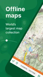
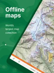
What is avenza maps: offline mapping app? Avenza Maps, #1 app for hiking, biking and all trails. Featuring maps from National Geographic, national parks and more!
On your next adventure, stay on track with GPS using offline mobile maps. Make your own maps? Import your custom maps and never get lost off the grid.
Explore the largest mobile Map Store of hiking, topographic, cycling, city, nautical, travel, and trail maps. Featuring maps from professional publishers including National Geographic, National Park Service, and the US Forest Service. Discover maps for your next camping, fishing, or backpacking trip with your family and friends. Navigate confidently when off-roading or taking those backcountry trails. Precisely identify your location with what3words and stay safe wherever you are.
Avenza Maps is free and the best map app for recreational use. Maps are available for free or purchase from the in-app Map Store. Plus subscription is available for unlimited custom map imports. Pro subscription is available for professional users with full access to all features and mapping tools.
Avenza Maps for your offline adventures on all trails!
ENHANCE YOUR MAPS WITH THESE FEATURES
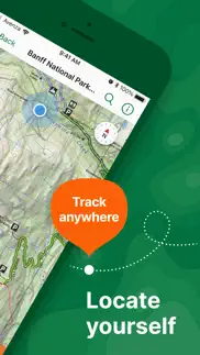
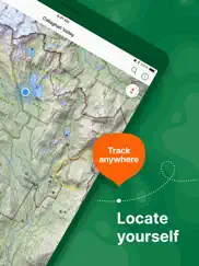
- Locate your realtime GPS position and find direction, even when offline
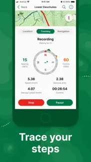
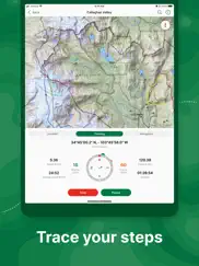
- Record GPS tracks during your activities
- Navigate to features using compass tools
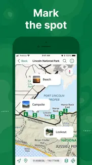
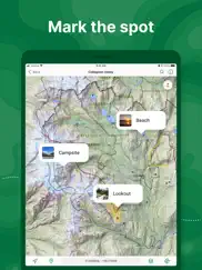
- Add photos and notes to any location
- Add placemarks to your map and style them with recreational symbols
- Measure distances and estimate times
- Supports KML, GPX, and CSV Formats
EXPLORE THE MAP STORE
Search and download maps by activity, category, and specific publishers with premium maps from:
- National Geographic
- Michelin
- Backroad Mapbooks (BRMB)
- New York - New Jersey Trail Conference
- USFS (United States Forest Service)
- USGS (United States Geological Survey)
- FAA (Federal Aviation Administration)
- NOAA (National Oceanic and Atmospheric Administration)
- BLM (Bureau of Land Management)
- HarperCollins
- DeLorme Atlas & Gazetteer / Garmin
- BaseImage
- National Park Service
- And thousands more!
A free account lets you access all of your map downloads.
GET MORE WITH AVENZA MAPS PLUS
For recreational and power users who need more
- Unlimited import of your own geospatial PDF, GeoPDF®, and GeoTIFF maps
- Create geofences for up to 50 individual features and up to four geofence layers
GET EVEN MORE WITH AVENZA MAPS PRO
For professionals and organizations who require an offline mapping solution with location awareness with more features and tools
- Unlimited import of your own geospatial PDF, GeoPDF®, and GeoTIFF maps
- GPS averaging, additional coordinate display formats, custom symbol sets
- Connect high-accuracy GPS devices including Trimble, Bad Elf, and Dual via Bluetooth
- Created unlimited geofences and get global geofence notifications
- Convert tracks to areas
- Map orientation lock
- Import and export Esri® Shapefiles
- Import and manage custom symbology sets
- Priority technical support
Avenza Maps Pro subscription required for commercial, academic, government, and professional use.
Avenza Maps Plus and Pro are available as annual subscriptions. You can subscribe and pay through your Apple ID. Subscriptions are 12 months in duration and will automatically renew unless auto-renew is turned off at least 24 hours before the end of the current period. Your account will be charged within 24 hours prior to the end of the current period at the rate of your selected plan. Auto-renewal can be turned off in your iTunes Account Settings. If you didn’t use iTunes to subscribe, you can manage your subscription through Avenza.
SUPPORT
We can help! Go to support.avenzamaps.com
LEGAL
Privacy Policy: avenzamaps.com/legal/privacy-policy.html
Terms of Use: avenzamaps.com/legal/terms.html
CONNECT WITH US
avenzamaps.com
facebook.com/avenzamaps
twitter.com/avenzamaps
instagram.com/avenzamaps
😍 Do you love Avenza Maps: Offline Mapping app? Please share your friends!

Please wait! Avenza Maps: Offline Mapping app comments loading...
Avenza Maps: Offline Mapping 5.2.1 Tips, Tricks, Cheats and Rules
What do you think of the Avenza Maps: Offline Mapping app? Can you share your complaints, experiences, or thoughts about the application with Avenza Systems Inc. and other users?
Avenza Maps: Offline Mapping 5.2.1 Apps Screenshots & Images
Avenza Maps: Offline Mapping iphone, ipad, apple watch and apple tv screenshot images, pictures.
| Language | English |
| Price | Free |
| Adult Rating | 4+ years and older |
| Current Version | 5.2.1 |
| Play Store | com.avenza.avios |
| Compatibility | iOS 15.0 or later |
Avenza Maps: Offline Mapping (Versiyon 5.2.1) Install & Download
The application Avenza Maps: Offline Mapping was published in the category Navigation on 19 September 2010, Sunday and was developed by Avenza Systems Inc. [Developer ID: 387212805]. This program file size is 226.29 MB. This app has been rated by 110,525 users and has a rating of 4.7 out of 5. Avenza Maps: Offline Mapping - Navigation app posted on 27 February 2024, Tuesday current version is 5.2.1 and works well on iOS 15.0 and higher versions. Google Play ID: com.avenza.avios. Languages supported by the app:
DA EN FR DE ID IT JA PT RU ZH ES SV Download & Install Now!| App Name | Score | Comments | Price |
Thanks for using Avenza Maps! What's new in this version: - Performance improvements and minor bug fixes
| App Name | Released |
| ParkMobile - Find Parking | 04 April 2010 |
| Parking.com - Find Parking Now | 07 August 2018 |
| Google Maps | 12 December 2012 |
| Citi Bike | 21 May 2013 |
| EVgo EV Chargers | 17 October 2017 |
Find on this site the customer service details of Avenza Maps: Offline Mapping. Besides contact details, the page also offers a brief overview of the digital toy company.
| App Name | Released |
| Sun Seeker - Tracker, Surveyor | 04 October 2009 |
| Trail Treker | 22 December 2016 |
| Cachly - Geocaching | 11 December 2015 |
| NavRules | 07 March 2011 |
| Theodolite | 30 November 2009 |
Discover how specific cryptocurrencies work — and get a bit of each crypto to try out for yourself. Coinbase is the easiest place to buy and sell cryptocurrency. Sign up and get started today.
| App Name | Released |
| Spotify - Music and Podcasts | 14 July 2011 |
| Threads, an Instagram app | 05 July 2023 |
| Google Drive | 28 June 2012 |
| Messenger | 09 August 2011 |
| WhatsApp Messenger | 03 May 2009 |
Looking for comprehensive training in Google Analytics 4? We've compiled the top paid and free GA4 courses available in 2024.
| App Name | Released |
| 75 Hard | 19 June 2020 |
| Plague Inc. | 25 May 2012 |
| Muse Dash | 14 June 2018 |
| Bloons TD 6 | 14 June 2018 |
| True Skate | 18 October 2012 |
Each capsule is packed with pure, high-potency nootropic nutrients. No pointless additives. Just 100% natural brainpower. Third-party tested and validated by the Clean Label Project.
Adsterra is the most preferred ad network for those looking for an alternative to AdSense. Adsterra is the ideal choice for new sites with low daily traffic. In order to advertise on the site in Adsterra, like other ad networks, a certain traffic limit, domain age, etc. is required. There are no strict rules.
The easy, affordable way to create your professional portfolio website, store, blog & client galleries. No coding needed. Try free now.
Avenza Maps: Offline Mapping Comments & Reviews 2024
We transfer money over €4 billion every month. We enable individual and business accounts to save 4 million Euros on bank transfer fees. Want to send free money abroad or transfer money abroad for free? Free international money transfer!
Maps not truly accessible on multiple devices. My husband purchased a map of the Sierra National Forest on our iPad. It supposedly could be accessed on multiple devices. He logs in to his Avenza account on his iPhone and there’s no map in his download history. He says to restore previous purchases and nothing happens. I try the same route. No previous downloads. Then the kicker: restore previous purchases requires me to be in his iTunes account. So even if there was a previous purchase to restore (which there wasn’t in his iTunes account on his iPhone), I wouldn’t be able to access it. The app doesn’t work as advertised.
Very well done app. I use this while riding UTV and Boating. The offline use is very good. GPS tracks are accurate and easy to do. Once you get an understanding of how to use the layers and attributes, it is very powerful. Some better tutorials there would be good but if you play with it you can get it. Would be nice to synch data between devices. I had a billing issue and the customer support was very good to get it resolved. The search for maps feature on the app can be a little cumbersome. It will sometimes bring uo search results that make no sense to what and where you are looking. The online desktop search works better but make sure you are signed into your account. Would be nice to be able to edit a track, especially when you forget to turn off tracking. 😁
Nice features, but horrible search engine. Don’t bother with this app unless you plan to upload your own maps. If you do, the PDF tracking features are great, and transferring a GeoPDF from e-mail just works — no trouble, no fuss. Unfortunately, the built-in map store is all but unusable. I’m not exaggerating when I say that it has *the* worst search engine I’ve ever seen. It’s extremely inaccurate. It has no apparent way to refine search terms (except a few built-in options, which aren’t much use given the rest). It doesn’t recognize quotation marks. There’s no way to exclude terms. I literally cannot find specific US national forest maps by searching the name of the forest — most of the time, they simply aren’t in the results. It’s incredibly frustrating to have such a potentially awesome app made unusable by search alone. Please, devs, *fix* it!
Decent. When I am able to get the maps they work well but that is a BIG if. The button to “download” a map have writing that is illegible so you can’t read the price. There are two buttons below that, which I have no idea what they say because again the words are shown illegibly. It doesn’t tell you when a map is downloaded when click the box that I think says download. When I search for a specific free map it won’t show up unless I specifically use the link from another site. And at least half the time the maps don’t download. So many bugs make this an app o would not recommend but it is the only app where I Can get NYS park maps for free so I am stuck with it
Piece of crap.. The only good thing above this app is that it’s free, but you get what you pay for. Ive been using it since the beginning, and every time they update their software it gets more difficult to use. Suppose for example you want download maps that you’ve used before, but aren’t on your device. This might happen because you had to delete the app due to corruption and start over, which I’ve had to do several times. There’s no way to tell it to download all maps not on the device. You have to scroll through a list of your maps and select the ones you want. But beware, if you happen to touch the wrong area while scrolling, you have go back to the top of the list and start scrolling again. Due to glitchy responsiveness it’s almost impossible to scroll far. This is just one of he crappy aspects of the app. I could write a thousand pages, but will stop here.
Recent update no longer accurately mapped. After this most recent update, all of my pins as well as my location are now on the very small reference map at the bottom and not on the main one. Is there a way to revert back to a previous version? Update 11/5: after a couple of version updates, my issue was finally fixed. Thanks to the developer for their efforts in resolving the problem. It would be easy for a company to forget about small concerns like mine but to their credit, they did not and got things working like new again. Thanks for all the help!
Minnewaska State Park Sam’s Point. I had downloaded the free map of this NY state park. This was my first time using this app and did not know what to expect. But the app was intuitive enough to use and I was soon tracking my hike. Seeing exactly where I was at any point in time gave me enough confidence of not getting lost that I hiked few extra trails marked in this map. Few times that I did get lost I could get back on trail looking at my tracks on the map. Overall a great first experience of using the app.
Perfect for public lands. Ability to locate public land boundaries I have been unable to find anywhere else. Make sure you have the maps before you go. Should not have to tell anyone that but, it is a strange planet. Not very intuitive when it comes to searching maps in the map store. Takes some figuring out but worth the little time it will take to get your sea legs. Maps with specialty info such as land plats are available. Which is Awesme! Some maps are a bit spendy. Would have been five stars if not for the prices of certain maps. GPS is spot on and battery usage makes it usable all day.
Official Maps on your devices. Avenza offers a wide variety of maps from National Geographic and other sources that can be downloaded to your device and used to track your hikes on the various trails. Because the map is on your device and not online you don’t need an internet connection while in the field. On the other hand it would be nice to be able to share maps with tracks between devices by being able to store maps with tracks on line in your Avenza account while connected to the internet.
Daffodil Flats. I lead a group of 11 senior women (including myself in that group) to Daffodil Flats, which we changed the name to Daffodil Steep. I had been there two years ago and followed this map. I encouraged the ladies to download the app and map at home and to practice using the Base Map. I wanted them to get use to reading a satellite map. This map helped me to inform my fellow hikers with info ahead of time as to what to expect and while on the trail as to how far we were from each waypoint. I recommend using Avenza Maps.
Most valuable app I have. I volunteer for a small nonprofit museum and frequently hike and explore the old area we focus on. With Avenza, when I come across an area of interest, I drop a pin to reference later and have hundreds of pins currently saved. I have a lot of old aerial photos and it would be helpful in the future if Avenza had a way you could overlay a photo and rotate/scale it allowing the user to line up roads etc and use as a new overlay but still, Avenza is an amazing thing to have.
Natural Resource Management Assistant. I work for a land management agency and frequently utilize Avenza to help track treatments of invasive species and during planning and implementation of prescribed fire. I also use it in similar fashion on my private property, and for private landowners with whom I’m working for with my other job (private sector). The two things I would love to see are real time GPS positioning of the entire burn team (individual members), and on a personal level - a GPS dog collar compatible with the app for real time positioning display as well. Love the app overall.
Great Maps, Interface Could Improve. App is excellent for backcountry trips in areas of poor cell service. Interface is a little complicated and unclear. If there was an intuitive button to walk users through all the functions either when they first start using the app or before a trip after not using the app for months, that would be amazing.
Slipping a bit. This is one of my major hiking pre-plan go-to apps. I still eyeball it, but the store has gone all wonky somewhere along the line. Trying to download the gazetteer for an upcoming Maine trip, but it just refuses to cooperate. First, the search returns hits for Kentucky and Arkansas near the top of the results list. Under what ridiculous search algorithm would results for Maine get pushed below other states? Further, it is only returning individual Maine maps at 99¢ apiece, rather than offering the whole gazetteer bundle in one shot, like it did for other states I own. Not buying 50+ individual maps, for neither all that hassle nor the price. Tried sorting for highest price first, hoping maybe a full bundle would bubble near the top of the results list: nope. Some $7.99 irrelevant result came up, while every other search result I had just been viewing literally disappeared entirely when sorted that way. 4/5 stars: fact is, what I have from Avenza right now is awesome. I just can’t seem to do anything in terms of conveniently expanding my library, for the moment
Pretty good app. I use this app while flying. And it works great. I think it’s performance really depends on the quality of the map you add. My only real complaint and it is really not a complaint only a suggestion is that I cannot zoom in or out while wearing my flight gloves, like any other app I use while flying. Most other apps have added a plus or minus button that you can zoom in or out with using a stylus which is what I have to do when I fly. I would like to see a zoom plus or minus button add it to the map page
Great app. I’ve used this app for years and I am finally getting around to writing a review. I recently had to access customer support and they were immediately responsive and helped me with my problem. A+ service. I live that once you purchase a map, you own it and don’t have to pay a subscription. Finally, as a mushroom hunter, I often go off-trail and I love that I can download the appropriate map on my phone, turn the phone to airplane mode ( to conserve the battery) and use this app to satellite track my location on the map not only to mark a mushroom spot but also to help guide me back to a road or trail if I’m in need of that!
New update needs work. Really enjoy using avenza, I’m already missing the older version though. I use it every day for work, especially tracks, draw and measure tool, and map sharing. The new update feels “fatter” to me than the previous version. Pins and icons take up way more screen space on my phone than they used to. My biggest gripe so far is the draw and measure tool is now very clunky and I need two hands to operate it and the tool takes up the whole map on my phone which is not fun in the field.
Love this program. This has been a great program when running the trails in our can-am utv. The only thing I wish it had the ability to do is change the pointer to something other than a dot. It gets very difficult to tell which way you are going sometimes. A pointer would be fantastic I would also love the ability to change the width of the track and also the color of the track.
Great Map!. This app has many cool features. I love the “pin” feature. When we park our car at a trail I insert a pin exactly where the car is. If you turn on the “recording” feature you can track the route you have taken as well as how far you have gone and the speed you are hiking. To me, the main comfort is that you can never get lost with this app. However, my strong recommendation is that you bring an external battery and have it connected to your phone so you don’t run out of juice.
Good app, comes in handy. We’ve used this app many times to find maps of areas we are traveling to for camping and hiking. Several times we ended up with no reception and these maps helped us get back easily, even will show your location on the map if there is a brief signal. Only two wishes for improvements: when a map expires, have a link or suggestion for a replacement map. And better descriptions for why one map may be better than another-Yellowstone for example has so many available maps for free or to buy-but which is the location, level of detail, etc that you want?-can’t always tell by the descriptions.
Nice find!. Thru the National Park website I found Avena and gave it a try. My family and I did some hiking in New Mexico. White Sands and Grindstone. These were my test try's. With no cell signal it worked perfectly for me. White Sands I purposely walked away from the parking area I was at and it showed me my direction and parking. At Grindstone it showed me all the trails. As we hiked our 8 miler it shows you in real time exactly where I was on the trail. Next in Oct I'll use it at the 5 Big NP's in Utah. Definitely this app is handy, love it!
You usually get what you pay for…. Not with Avenza, It’s free!. I love this app for easy navigation while riding dirt bikes through the mountains. It’s very accurate and easy to use. The only challenge can be finding maps but it’s getting better all the time. Put the phone on airplane mode, give the app full location permission, start tracking and open it up when you wanna see how you’ve gotten yourself lost. Love it. Chrisjf250
Smart tracking, clunky interface. Often overlooked are the app’s intelligent tracking capabilities that are very customizable and can yield more accurate tracks with less noise than many leading GPS apps. However, you will be hard pressed to reliably export features like tracks to other apps because Avenza’s approach to layers is just all wrong. So bad. Record a track and you should be able to name it right away and have it be findable at top level directory rather than buried in a sea of Avenza’s generic, self-named Layers. Tracks and waypoints should simply transfer to other apps via iPhone’s Open In sharing option, but because your actual track is a so-called Feature within a Layer and never expressly named, you can’t reliably locate it during export. It’s a shame because Avenza isn’t realizing the full potential of what is good about it, and I feel it’s due to misunderstanding its user base and believing all they want are digitized PDFs they can draw on. This is the niche around which the whole ecosystem revolves.
Amazing app for national forest lands. I got this specifically to get our local National Forest maps, without knowing how wonderful it really was. I’m so glad I did. I am able to plot pins in favorite little hidden campsites, lay tracks so I can navigate back to unusual places or check how long it takes to get there. I can even add photos to those spots. Buying the national forest map so this way costs about half the price of the printed versions and with the advantage of being interactive. Another major bonus is on my phone it works off satellite and doesn’t depend on cell service. Many national forest areas have no cell service but I can still use the map. Of course it does use up your battery so there’s that to prepare for. I charge it when I’m driving with my cigarette lighter adapter. I’ve also found many local free maps (or very cheap) such as geological surveys.
The best for hiking/biking. Doesn't drain the phone battery!. I've tried several other apps for hiking/biking in (un)known areas and there was always some issue with them: or they would drain my phone battery in an hour (not good when you are far in the wild), or they wouldn't have all the trails/paths/roads mapped or they wouldn't show accurately my location at the moment (crucial on a new trail). This app has it all! Really have been a saviour when I would get lost in the woods and it also makes exploring new routes adventures, enjoyable and interesting! The phone doesn't seem to lose power faster then in normal circumstances. And your current location is shown even if you have zero bars of connectivity and google maps fail. Highly recommendable and big thanks, developers!:)
Great Capabilities but hard to find maps. I have to search for maps through the website because it is near to impossible to find what I want through the app. However, I love the capabilities of this little thing. Being able to place mark and open up points within google map (or vice versa). Also I LOVE the fact that it operates like a GPS when in the map area. You can follow your little blue dot while traveling through the forest. And it’s scary accurate. Loving this so far! Can’t wait to place mark all the beautiful spots in AZ that I explore.
Unusable topographic maps. I bought the app for topographical maps. I downloaded a set of maps around Placerville, CA. At least one failed to download due to errors. I tried multiple times without success. My query for assistance, which included all the info they requested went unanswered. The maps I downloaded were all the smallest scale, a few miles on a side. There were no large scale maps as a reference, nor any way to link them to any other map to know the area any of these maps referenced. Just a big empty grid like a piece of graph paper. They were almost totally useless. The only good feature was I could hit a link that popped up the map of the immediate area I was in. Very nice feature but not of any real value in how I wanted to use them. I would take my money back in a heartbeat!
New device. Update: Apologies to support, which was in fact responsive and helpful. The online support was inadequate, but humans came through. I now have the purchased maps again. While I simply never should have lost that data in the first place by upgrading my phone, the matter is resolved with reasonable efficiency. All purchased maps LOST. Wasted money and crap support. Shop elsewhere unless you’re willing to lose what you purchased when it’s time for a new phone.
One of the best apps. This may be the most useful app on my phone. I do a lot of hiking and camping off the grid in California, and this app has saved my bacon a number of times. You have access to hundreds of high quality maps, and as long as you download the map ahead of time, you don’t need cell service to access it and see where you are via the gps on your phone. Highly recommended.
Best Map and Navigation App!!. I have utilized many applications to track and search for all things outdoors. This app is by far my most favorite and most thought out app for any of your outdoor adventures. The best part is that there are so many amazing features within the app for free. The GPS tracking worked phenomenal and was even more accurate than other applications without cellular service. Plus, the paper maps are just as great and it is fun to be able to plot on the fun outdoor spots.
Map Theory. I love this method of modern cartography. my favorite is the Beartooth Maps specifically for hiking and biking. I am a land surveyor and this is the best way I have found to get the exact map I want for the purpose I need. Once downloaded you can operate offline without any extra steps. The map store is simple and does not require you be a land surveyor or cartographer to figure out what you need. I wish there were more companies that would consider adding their maps to the store here in the mountain west. This is the only downside I could find, I want more maps.
Goto App for Wildland Firefighters. Every wildfire incident offers maps in Avenza format now. Using the iPad in our fire engines, we’re able to load custom incident maps of forests, plot locations, draw tracks, hike trails, etc. The best part is, if you download the maps ahead of time, you don’t need internet access to utilize them — making it awesome for remote forest use. This app has become an essential tool for incident management and tactics.
Great app!. I've been using this app for several years. I share a single account across all my mobile devices. Instead of needing to buy paper maps of things like National Geographic trail maps, I can buy them for the same price in this app, and have them gps enabled, traceable, and portable. My local open spaces org recently uploaded all their trail maps to the Avenza store -- and they are free to download! Also a big fan of the Redwood Hikes company trail maps. Great for pretty much everywhere in California that has redwoods and hiking trails...and cheaper to purchase here than buying the printed copies. I've tried pretty much every mapping and tracking program. If you want free maps like open source stuff, there are fine sources like Motion X. But if you want commercially available maps, I can't think of a better app in the App Store.
Superior off-line mapping to all other apps. Planning a 4 day dirt road adventure in the Sierra Mountains National Forest. I first made routes, to be used off line, with apps like REVER and RIDEwithGPS, which all use Google based maps. I thought I’d done a great job, until I cross referenced my routes on Avenza, which uses a jpeg of the particular map you download, in my case a Nat. Forest map. I realized my route went through many closed trail gates!, so it was worthless. I created a a new route on Avenza avoiding closed gates. This app is essential for back country exploration.
What happened to searching for maps?. I used to love Avenza. I still use it with the maps i have in my collection, but to search for a new map, forget about it. I liked that you can put searching maps for recreation but now that option is gone so you get ALL the types of maps they have on file. I need hiking trails not topographical maps or other kinds of maps. Don’t even bother searching a specific area because it will send you somewhere else not even in your own State. The buttons cut off so you just see the top of the word (Download, next, previous...) so I have to guess what it says without pressing the buy button. So frustrating. I want to love this app again since I’m always out on the trails. Fix the problem please so I can get new maps without going to a different app.
Hunting with Avenza. Have used your app to hunt in Montana, Colorado, Idaho and South Dakota. Love to see where I am and all the detail available. Will use this fall on another site in Montana to hunt birds and deer. Hunt with 2/3 other guys and we all use them. Wish you had system to follow them too as we hunt in a loose group and want to keep track of each other. Some difficulty with finding the maps. Need more practice but some times confusing if don,’t know exact name of area or there are numerous pins in same proximity. All that said, we are glad we found Avenza maps. Keep up the good work.
A Must Have. I absolutely love this app. My family enjoys hiking, biking, and off highway motorcycle riding which is where this app excels. For all you single track and trail riding motorcycle enthusiasts find your map by searching for either “MVUM” (multi vehicle use map) and/or “OHV” (off highway vehicle). No worries about cell service as this app utilized the GPS in your phone. I also love the ability to plot photos and mark my trails which makes it a joy to share later with friends. A feature I would like to see added would be the ability to share my recorded “track” via a simple text. The track would then be imported into other applicable maps and more importantly with friends who also have the app and corresponding map(s) so that they could follow the same track at a later date.
Forest Service MVUM maps. A little hard to find the specific USFS MVUM your looking for because government bureaucracies have zero creativity when it comes to map titles,but if your accustomed to using MVUM’s - then Avenza is the source for these free maps. I used them for the first time last summer on a dirt bike trip to Idaho. The GPS tool worked on my IPhone 6 just fine and it was very accurate. I carry a GPS and Spot, as well. But, I always went to Avenza on my phone first. 1’ve only scratched the surface of available features, but I have a friend who laid out the Black Hills KTM rally using it and it was a great tool.
Best Navigation App Ever. This app is amazing. You can get maps for just about anywhere you want to go, download them, and then when you are out hiking, driving, whatever and beyond cell phone service you will know exactly where on the map you are. A real life saver. I use it all the time and go places and on roads I would not have been completely comfortable with without knowing where I was and how to get back. Customer service is also awesome!
My time with Avenza. I was up on top of a mountain top hunting driving life four-wheel-drive of theSome steep hills and I saw a lady sitting on the road and her bicycle laying on side and I thought she may have crashed I pulled up and asked her if she was OK and she said she was fine she was just riding over the mountain. She saw me looking at some paper maps for the roads and she told me about a Venza and that’s where my experience with the van to begin I am so impressed with this program as with on X without satellite feed you can’t use the map but with Avenza you can use the map and it tells you where you’re at every place you are magnificent program thank you very much strange lady on the mountain and thank you Avenza Randy Watson hunting near Garibaldi.
Upper Mississippi HIGHLY recommend. I have been using Avenza Maps to navigate the upper Mississippi River since last year. It provides real time GPS positioning on their map app. I downloaded individual US Army Corps of Engineers navigation river maps from their website into this app, and using my ipad or iphone, gps positions me EXACTLY where I am in the channel. I verified the accuracy to within within about 10 feet! Easy to navigate in the dark now! Thus I can see all the wing dams, and my relative position to them, and the channel is highlighted in white. The ONLY slightly negative thing is you have to manually switch between each river map when you go off the current map. I have boated now over 200 river miles using these maps with high accuracy, since a long river trip last summer. The only limitation I found is that the USACE has moved the channel slightly in some areas, and the most recent USACE navigation maps edition don’t show these changes. (NOT the apps fault)
My go-to hiking navigation app. Hands down, this is my favorite app to use while hiking. I am in New York City, USA and I do most of my hiking in the highlands north of the city. Avenza has really high quality maps showing all the local trails. It tracks my location on those maps and doesn’t use too much battery. I also like the ability to record GPS tracks. I would give it a 5 except for a few clunky features that are a bit hard to use. It is hard to get the tracks to disappear off a map without deleting them altogether. They obscure the view of that map for subsequent hikes. I would also like the ability to draw paths freehand to measure trail distances. As it is now, you have to create a series of straight line segments that don’t mimic actual trail geometry. Overall, though, I haven’t found a better app for the price. And, you can buy and download the maps. I used this for a trip to Athens!
Great map tool.. I have been using for a few years I like how reliable it is and you never have wonder if your map will work offline. I purchase a lot of forest service maps which can get expensive but I like knowing I am using an official map. The black and white motor vehicle use maps are all free and work ok but I like to see topography so I choose to pay for the better maps. Keep up the good work. I’d wish it could be made easier to search for maps I want. Usually is search then click through the results trying to find right map.
Great App. This is a great app that allows you to track your location even without cell service. It allows you to name your tracks, add pictures, etc. The only downside is that, even though you have to create an account to use it, the data is saved on the phone and not online so if you switch phones and you’re not just restoring your old data, you lose everything. Other than that, this app is very user friendly and has great information and tracking!
Outstanding Raster Map Application. Serious GPS users recognize that there are 2 types of mapping apps: raster and vector. They are not the same and suffice different purposes. I wanted to publish a map that our people could use for the Audubon Society Christmas Bird Count (CBC). This use case suggested the need of a raster application. Our folks also need an app that is free and easy to use. Preparing the CBC map on my GIS work station (QGIS) and exporting to Geo PDF for use in Avenza has proven easy and accurate for me. I look forward to serious field use this Christmas season. Avenza ‘just works’. The Avenza App Store is outstanding in that it offers both gratis public domain and paid resources. The app supports a variety of use cases, many of which are beyond the immediate need of the CBC but which are greatly appreciated. Thanks and keep up the good work.
Very poor quality topo maps. Unlike many negative reviews mine has nothing to do with being upset about Avenza moving to a pay per map model. That's fine to me. I'm happy to pay a few dollars for a useful tool. What upsets me is that I have paid money for a worthless map. What is described as "the finest available" map is actually a low resolution image that is quite useless. Zooming into the map reveals the low quality image. The topo elevations are 100% illegible, as are most road names. Google maps provides more detail and features than this map did, and that's a free. And since google has added a feature to download portions of a map for offline use, I used G maps more than the Avenza maps. Again, happy to pay money when it is worth it. This was not worth it.
The only map app I use for work.. Avenza maps application is very detailed and depending on the map your using can help you with backpacking, work, traveling and recreating. I personally use it most for work because I am a wildland firefighter. It helps immensely with navigating through areas I am unfamiliar with, minimizing the hazard of becoming lost in potentially high stress situations. I would recommend this application for anyone who works outside or plays outside. Also I don’t know if I mentioned this but it works offline and will show your approximate location even without service. Applause to avenza!
Frustrating App. I’ve been using the app for approximately six months during a handful of off-road trips. It’s adequate when you acquire a map which is originally done in PDF (such as from Tom Harrison, National Geographic, and some others). Many of the maps, however, are in fact sourced from compressed scans of printed maps (or low quality renderings) that are virtually unusable when zoomed in to ascertain area details. The store does not indicate which are native PDF and which are scans. Many of the better available maps are available in hard copy for essentially the same price, though missing only the nice ability to use your device’s GPS to indicate and track your location. An issue of all mapping apps is that it’s sometimes nice to spread out a paper map to get the big picture as something is lost when you use an app such as this to zoom out making features so small that they’re unrecognizable and text unreadable. Overall, if you needs maps, you’re much better off getting the much more capable Gaia app and suffering the subscription fee which you’ll quickly rack up in a handful of maps with this app versus unlimited maps in Gaia. I think there’s a place for this app if you restrict yourself to Tom Harrison maps or are able to get lucky and find native PDF maps which are not available on Gaia, but all of the Nat Geo Trails illustrated and topographic maps are in Gaia ... and much easier to find and download.
The most useful. I live surrounded by national forest. I own many of the popular apps. I find this one by far the most useful and use it more often than any other. It also has the most accurate and complete information info regarding dirt roads and their numbers. Simple, intuitive, robust and useful. If you just want a clear, accurate map with tracking and other functions this is it.
hardly worth it. I got this app for the free VA State Park maps. I guess you get what you pay for- the information on hiking trails is incomplete and rudimentary and the maps are low information content. However the app itself gets downgraded for the braindead download interface. If anything happens during a download ( which can take a while especially when you are away from fast wifi) the download simply stops and/or starts all over again. Even if the iPhone screen turns off! I spent the better part of an hour with repeated attempts and finally succeeded by keeping the iphone screen on without doing anything else that would have immediately cancelled the download again
Did you know that you can earn 25 USD from our site just by registering? Get $25 for free by joining Payoneer!
Lost Touchpad Support. This app was one of the few map apps where I could move around a map using the touchpad on my iPad Pro keyboard by just two finger swiping. With the latest release, I now have to click and hold whilst swiping to move around. Not nearly as good as it was. The app is also a bit laggy now.
Amazing for hiking. It does an amazing job at allowing you to pin point your location. You can use it in flight mode and it is amazingly useful for anything outdoors. Maps are very affordable and I would advise this app for anyone going hiking!
Best Map App. Hands down the best map app available. Free maps are good Topo maps for sale are brilliant. Government hunting and fishing maps are so easy to use
Useful in some ways. Got this because NSW DPI require it for hunting permissions. It is ok, particularly for those who are not into or trained in navigation. A proper gps navigation unit such as garmin will beat any app any time out in the field particularly on foot, phones cannot be trusted if your navigation is crucial. Having said that this app is very functional, perhaps more so than the hema, but the hema app maps are superior for Australian users. I think this app would suit allot of users.
Good support. I initially had issues getting adjacent maps to link up. The tech team responded straight away and helped me out.
Excellent - add one feature please!. An excellent app for hiking and remote fieldwork. But an excellent addition would be CarPlay support so that maps can be seen on a larger screen while driving for navigation! Easily would add the 5th star for this feature. Thank you!
Can’t beat. On iPhone there is nothing that compares to the ability to share maps with no phone coverage that Avenza does Takes a bit to get used to all the functions but once you learn you won’t beat this app
Maps. I wish I could transfer old maps from my old phone that I didn’t pay for as I have to pay for them now if I still need them.
Great product. Fantastic easy to use and lots of maps for free, I purchased some also, highly recommended
Outstanding technical support. I had a tricky technical issue, which I contacted Avenza Systems about. The support specialist could not have been more helpful in resolving the problem for me. Best tech support I have ever had for an app!
Thanks. Hey guys your mapping system has been amazing and I can’t thank you anuff for it !! Only change I would make would give the maps more detail or be able to make multiple dot points with an option of writing in information as well
Great but room at add features. I got put onto Avenza by one of the Dfes team at a fire for help tracking our movements and location while on the fire ground. It’s great being able to get a map emailed to me and upload it and away we go. There are a few features I’d like to see (some might be there but unable to easily find), - the ability to rate maps in the Avenza store, I spent $5 on a map that really doesn’t have the details I wanted/needed but there isn’t any easy way to know, if someone had rated this I could know or rate it for others to be aware of. - an easy way to share your tracking lines, I tried to share/export my tracking to email for the next strike team to use to easily find where we had been and where they were going but we couldn’t figure this out, every time we emailed the line, it needed up being literally a picture of a line, and not the full line. -ability to convert coordinates in app or use different types of coordinates for dropping a pin or directions. I was given a destination point by a spotter plane but the type of coordinates I was given I couldn’t enter into Avenza. Cheers James
Good access to free NP maps.. I’m no tech head, but have persisted and can now access quality maps for free! Would be nice if they could interact in real time? Maybe than can? Any clues.
Updated review. I had a few issues to begin with (it's not easy to learn your way around the app at first) but once I sorted the issues and took it for a test run on a remote 3 day hike then I was really sold. It's great
Great mapping system. I use Avenza for navigating in remote areas of the Northern Territory and found it better than any other system .
Great navigation app. Perhaps the best “free” map and navigation app I have come across for iOS. The free Getlost map series really completes the functionality of a great GPS system
Great App. If you are thinking about off road navigation this app takes a lot of beating for perfomance and price of maps. I was using VMS previously which has become obsolete due to screen size and the pain and cost of updating maps. Use google maps for turn by turn navigation and this app for off road. If you need to save detail grab a Garmin GPSNAV 64 or similar which are a hand held unit.
Get lost. I was quite happy when I found this app for Australia, more so because gps devices don’t upgrade their hardware and software anymore, at least not for Australia. A gps device feels clunky now compared to a phone with gps. . You can download all sorts of maps. This is all great. HOWEVER: You download maps and they should stay on your device. I have had it that I went for a trip to find that the app decided to delete my maps. I could of course download them but NOT when you are out of range (for when this app is supposedly working so well!) Apart from this it is actually dangerous not to have a gps with you here when you go bushwalking. I had to download 40 maps again. So thank very much! I am going to find a better app! I have not even complained about the rest, can’t be bothered anymore…. Good luck when you like to try this. I hope you won’t get lost… one word: UNRELIABLE
Easy intuitive offline navigation. Great app that gives access to a wide range of map/nav solutions without the need for connectivity at a good price.
Handy AF. Really handy app! First used it at work with PDF gps pointed maps. Have since downloaded Frasher island. There’s a blue dot that follows your position on the map. This can be used with phone reception and with out!!
Avenza fisheries work. I use Avenza maps for fisheries field work. 1:25,000 topo maps and find it fantastic. Accurate, reliable, detailed and simple. Also use it for back country hiking and it’s great!
Just sooo handy!!. I cant believe it took me so long to find this app! Clear, detailed and able to be used when there’s no service!
Geoscience maps. Previous geoscience maps that were free are not anymore. Why?
Way too basic for the subscription. Not sure why users like this app. Other importing stuff, it does not add ant value to the map reading experience. The tiny compass disappears when you touch it. How about a zoomed in view when I touch it. No co-ordinates, gps or map grid. AllTrails pro which I have has at least got substantial value, I cam see no value to Avenza. Feels like a hobby project . Compared to any other maptool, this one may as well be a oneoff $10 payment, because you will be paying extra for maps, if you can even find any. Will be cancelling sub. Good to see the devs respond from time to time.
Avenza adventure. Avenza features an array of functionality hooked up with a great interface that is intuitive. I love the ability to map locations and pin point navigation... very useful if backtracking. It’s great to have options to acquire maps that you only need. I have field test this whilst navigating bushland in Victoria, Australia. The scope to load google map views is really hand... like Ariel navigation without having to buy a plane. Also, refresh times are no issue. I prefer using this on my iPad and phone rather than my hand held navigator as screen features are a hundred time better... pinch to zoom, size etc. I’ll soon be trying the HEMI map feature because I am happy with Avenza.
Avenza - very useful in the NT. Given the sheer scale of the Northern Territory it is unsurprising that phone/mobile data coverage is somewhat limited to heavily populated areas (which are few and far between!). Having detailed maps which work off line and yet make use of the phones’ smarts is a very good thing! Explore with greater confidence (but be properly prepared!) Adding your own layer info is a great way to enhance the value of your travels - and gives you something of great value to share.
Fantastic app. Maps are quite affordable compared to paper copies or other electronic sources It’s great having the gps location on the actual topo map as it provides a very user friendly and easy gps device on a phone Would be even better if the app stitched the maps together but it’s not so bad having to work off multiple maps
Great app. This app is a godsend for anyone who works within agriculture and regularly visits stations and property. The ability to search and gps mark the destination is extremely helpful. Searching for your initial maps is a little clunky, however there is a lot of information out there so can’t be helped.
Learning to like it. I used the App for the first time on a recent trip through the Gascoyne region of West Australia and once I’d found the right map we were fine. We used the track your path option which worked well, and getting the bearing to our destination worked well. It would be good to have an index of the maps you’ve downloaded, to make it easier to go to the next map when you get to the edge.
Not very useful. This ap was recommended to me from a colleague. I have had nothing but trouble trying to get it to function. The ap does not provide functionality by enable you to specify where your base map is located (in my case in icloud). There is no means by which you can open up an existing base map and use the ap from there. In short I could not get any useful product from this ap
Fantastic. So easy to use. Even better if you’ve got your own georeferenced PDF map, but the store in the app is useful
Essential for property owners. This app allows you to create maps as you walk, ride, drive through a property. It allows you to pinpoint trees, water features and other points of interest. It comes highly recommended by people in forestry. I have yet to figure out how to load up on my own maps and those supplied by government departments but I am assured that it is possible.
Please give option for always access of location. I can’t record my location without having the app opened. It’s ridiculous. I just want it to use GPS to record trip at background. It shouldn’t be hard.
Your map app. I work a lot in the bush and have used all different types of mapping apps and this app has been the best I’ve ever used. Thank you.
BEST OFFLINE use maps for remote areas in Australia.. The Geoscience maps of remote areas in Australia are absolutely awesome. Have been blown away by the detail and accuracy of the maps of very remote areas every time I have used them. You can see exactly where you are at any time without needing internet connection. Most of the time FOR FREE! Has changed the way I travel. Was looking at other “paid for APPS”, but for my requirements, the free Avenza APP is the best.
Brilliant. I work in search and rescue and these maps are fantastic. The only thing I’d like is to find an easier way to tell which map I was on.
Ease of use. Avenza maps is so easy to download and navigate. The best tool is being able to record trips so you can find your way back.
Avenza shortcomings. Needs more magnification down to tighter detail. Needs more icon choices. Small list is too generic and leaves out hunting & fishing and even more specific orienteeringnavigation icons. Go see goHunt and other such apps for better examples.
Money grabbing scum. Don’t bother with this app, it is cheaper to just get a dedicated GPS if you want true ‘pro’ or ‘expert’ features that this company is trying to sell you. I paid for this app a couple of years ago. Had all the features they are now labelling as pro or expert etc. Recently updated the app and now I have to pay an exorbitant price to use it again. Be aware your phone doesn’t compare to a real gps and previously when this app was a reasonable price you could live with the short comings. However I wouldn’t waste your money with what this app has devolved into. What’s the reason I used this app in the first place? I was required by law to have gps capability when in certain areas and the governing body issued geo referenced PDFs for people who couldn’t afford a dedicated GPS device. It worked great for what is was but when you are required to have 50 odd government issued PDF maps it’s just not value for money anymore. Thanks Avenza, I finally have justification to delete your app and get a GPS/radio combo, I’ll know where I am with better accuracy, I can talk to others when out of phone cover and the battery will last a whole lot longer!
Bellie711. It’s making family hiking so enjoyable without the risk of getting lost. Really gr t to plan the hike as well. Offline maps and use of GPS huge tick Thanks Avenza clever stuff.
Best mapping system on the market.. I have been using this app for 3 years and for the modest amount of money to access multiple maps it is worth every $:)
Maps no longer available. Good app for navigation offline. However I purchased multiple maps last year in Tasmania. When transferring them to a new phone, I was no longer able to download because the maps were no longer available. If this is fixed I would rate the app 5 stars.
Great app. Great app....does everything I need for The 4wd trip we are planning.... The only thing I must have done wrong is download the Googs Track map before I created my account.... now I am unable to also download the map to my iPad .... went for a motorbike ride with friends today and was able to track our ride 😃
Warning. Bought a collection of maps covering most of the state. 700 maps. From the shop. Only to find it was a donation and the maps were freely available at another website. Downloading all 30 gb of maps required continuous internet connection. Help said we don’t understand what is wrong. Had to delete app and start again. Hours of time wasted. Not happy. Map was about fifty meters out consistently. How do you align them up perfectly? Can’t find help on that either.
Useful app. I find this a very useful app when I go bushwalking for both map location and recording GPS tracks of my routes. I wish I could find a way to export individual tracks for editing, rather than all active tracks, but nothing’s perfect. Serves the same purpose as a dedicated GPS device for me and my smart phone has a much better viewing screen than the tiny ones on those devices. If you carry a back up charger, there is no worry about power drain, even though active GPS tracking does consume the battery much faster than with the app switched off.
Maps are Lost. I have been using Avenza for 4 years now with no issues. Recently, two thirds of the maps I have paid for, show an error, and I cannot open them. Those maps I paid for are now lost, and along with them, tracked trips I have had. What’s happened to the maps?
Must have trail running app. Great app, gives an easy to read map that shows you where you are and where your going. Wouldn’t go trail running without it !
Wish you could connect maps. Pretty good. Wish you could overlap or connect maps that you’ve bought because sometimes you’ll do a walk that spans over sever maps and you keep having to switch between them which is a bit inconvenient
No Signal? No Problem. Wonderful being able to navigate in areas with no network. A must-have for every adventurer.
Smooth and functional, even on my old iPhone. I used Avenza Maps to navigate through the APY Lands in Central Australia, which is basically not supported on Google or Apple maps. There is basically no mobile reception for hundreds of kms there. I downloaded most of the maps before my trip but even the one map I hadn’t came down quickly while i had a coffee at a roadhouse on the way. The maps are well marked and quite accurate and the gps location follows where you are even without mobile reception. Great app!!!
Imagine you at your best. All the time. Picture yourself at your sharpest and most productive. Your most alert and focused. Your most lucid, creative and confident. At work. At play. In every area of your life. Add Mind Lab Pro® v4.0 to your daily routine and uncap your true potential. Buy Now!
Love it. I really like the application, but it would be awesome if the application was also on a Apple Watch. With that we would not need to take out our iPhone every time we want to look the map while hiking.
New Version is very annoying and NOT user friendly.. New Version is very annoying and NOT user friendly. Avoid updating to the new version, if you still have the older one. Make the app’s draw feature like the old app PLEASE! Tap anywhere to add point.
Nassau, Bahamas,. Bus map for #10 useless Give you nothing Should not be sold
GPS NEEDS WORK!!!. I’m gettin really fed up with how the GPS locator glitches. I’m logging on nights and I need to know exactly the direction and the location I’m at in real time. Fix it please.
Avenza m’appelle. Très intéressant pour chasse , pêche,facile à utiliser et assez précis.
Purchased maps disappeared. Maps I purchased last summer have disappeared and are no longer available on the map store. Buyer beware. I’ll be pursuing a refund.
Terrible rip off. Thought I’d be downloading something as good as the Maps2Go app that was already awesome 10 years ago. Instead this is garbage. Maps aren’t scalable vector maps and have limited search ability and functionality. A big waste of money. No more interactive than a paper map.
Pro is pricey. Great app, but like I said Pro Is very costly
Excellent. Excellent
Work amazingly. Awesome once you load maps
Merveilleux produit. Carte claire et précise
Bring back the old collections setup. The way collections work now is terrible. Zooms in and out and isn’t manageable. Also the way to measure on a map should be like the old way, just a simple tap of the screen.
Les carte ne telecharge pas. Jai changer de téléphone et quand jai voulu récupérer mes carte sa ne fonctionnais pas c’est écrit erreur sur tout mes cartes
Application. Super application
J’ai perdu mes cartes avec way point !!. Je suis déçu de ça mais vue que l’application est gratuite j’imagine que c’est normal !!
Very useful app.. Allows me to track my location and locate sites with precision whether using for work or recreation.
Great App. This app is my favourite, love it so much. Be nice to see it work on car play. I would pay for that app!
Wekusko lake. Very accurate and colours are terrific
GPS. Cette application est extraordinaire ça prend ça partout
Map of central Alberta. Don’t waste your money on that: you get more information, and the information is more up-to-date with Google..
To expensive!. The full version is way to expensive.
Too expensive and too limiting in free version. Three maps but even importing the second map brings up a warning that the map is inactive. First I had to register before I could even try the app. A demo map counts as one of the three. Importing a second map brought up the warning that it is inactive. While PDF maps seem to hold some promise for easy adoption, Avenza’s approach makes it a poor choice for even recreational use. It would be better to offer a month trial first.
Poor tech support. I purchased and downloaded the plus so I could used a friends hunting map he created and when I reached out to support to help with an issue they wanted me to pay for the pro version. Other people can easily download the map and for some reason it won’t upload into Avenza. Probably an easy fix in my settings that I’m missing but the tech support won’t help me.
Parfait pour connaître les plans d’eau. Avant partir tu peux planifier ton chemin et plans d’eaux pour ton voyage de pêche et sans te perdre
Merci. Très bon complément avec un gps Merci
Préparation voyage de chasse. Contente de savoir que je pourrai me retrouver si je me perdais en forêt.
Rafferty. Love the new map. The best I’ve ever used. Thanks for this.
Pratique. Très très pratique. Merci.
Juste super. Ça va mieux que mon gps . J’adore l’application !!
Recent decline in UI?. Hey all! @ dev support. I’m experiencing a recent issue with Avenza. (Past 6 months or so) Every time I go to change the map view, the app doesn’t respond to my touch. I’ll need to do what ever I’m attempting to do, twice. I.e. change the zoom, move around my location, set a pin, calculate distance, etc. Another extremely common issue I’m having is that the gps is not locating me. I’ll have to close the app and reopen it to gather an accurate positioning (this may be more of a phone issue?) idk. But it never used to be a problem and now it occurs every time I open the app. Very disappointing :( I’ve used Avenza for years. I recommend it to everyone, especially with the addition of BRMBs. It’s completely replaced my Garmin! But given the recent issues, I’ll be keeping my eyes out for an alternative solution. If you have any suggestions on how to fix this, please let me know :). Happy to share more context as well to help solve the bug! Best
Guide de rivière sur le téléphone. Très utile d’avoir une carte topographique avec le guide des rivières à même la carte. Les courbes de niveau aident à décider quel côté de la rivière semble plus propice aux portages
Nice app but HELP. I couldn’t figure out how to use the app. Bought two maps of an area but then the area I was looking for was not within the boundaries of either. Now I have two maps that are useless. Even with those two maps, can’t figure out how to use them. I’ll need to play a lot more with the app but bottom line is it is not user friendly. Not for me anyway.
Reflective rating. Reflective rating will likely improve as I practice more. Was unable to what I needed to on free version, but that did give me a good introduction to the app. At this point, I am excited to practice on the Avenza Pro. Hopefully I will be able to improve and make good use of this tool.
The best app for hunting far out in the northern barrenlands. Vary vary good app for hunting if your phone don’t die out in minus 60 weather
Laggy new update. Incredibly laggy on new update
Yesssss. Très utile dans ma Zec: Chapais!!!
Field tech review. Extremely user friendly and efficient. Handy to have everything on one phone rather than multiple devices
Pro version. I would like to have the possibility to buy the version PRO for one month in order to try it! Why this is mot possible?
Magnifique. Je commence à le découvrir mais j’aime beaucoup
Moteur de recherche pénible. Très compliqué de trouver une carte, une fois trouvé tout va bien
Maps. Love the simplicity of the maps. However. I do wish the number for the depths were larger for us old guys. Other than that the maps are great.
Please make the app available for imac!. The app needs to be updated so we can use it on a imac!
New Horizons has made your app very laggy. I’m on an iPhone 11 Pro. Really disappointed with this update - things are noticeably laggy and less responsive now. I use this app professionally all day so this is really a problem for me!
Offline maps. Love getting offline maps for my fave hiking trails and parks. Can you add more filters to the Map Store? Thanks!
Long time user not happy anymore. There is something wrong with the new Avenza. I miss tap anywhere to add point when measuring distance, location is sometimes off, track recording sometimes stops unexpectedly, the app freezes, maps don’t load and I need to restart the app. Few of my coworkers also complained about location issues. It was my favourite navigation, not it’s just frustrating.
The only mapping/navigation app that still does not support split view functionality on iPad. I don't understand why after all this time Avenza still does not support split view functionality on iPad. Apple added this very useful feature two years ago and other mapping apps promptly implemented it in their updates. It comes very handy when working side by side with another app such as a travel/hiking guide when planning a trip.
Sa remplace un GPS de $500.. Merveilleux. Je ne me sert plus de mes 3 GPS depuis que j’ai cette application. Pas besoin d’aucun réseaux cellulaires. Un bijou pour une fraction du prix. Et pouvoir basculer entre Google Map et Avenza est ben d’addon.
Carte. Je débute à peine,je connais pas encore vraiment ça
Just Use google maps. I bought a map to get a better look at backroads for hunting but it is worse then just using google maps.
Très utile. Utilise dans le bois et pas besoin de gps. Excellente carte. Sylvain h.
Adsterra is the most preferred ad network for those looking for an alternative to AdSense. Adsterra is the ideal choice for new sites with low daily traffic. In order to advertise on the site in Adsterra, like other ad networks, a certain traffic limit, domain age, etc. is required. There are no strict rules. Sign up!
It’s broken. Since the latest update the app hasn’t been working properly at all. It used to be flawless but now it keeps freezing. I’ve tried customer support chat a few times but that wasn’t helpful either. I may have to cancel my subscription. It’s very disappointing because I use it for search and rescue in the woods. It stopped working on all my Apple devices. iPhone 12 Pro. iPad 12 pro. iPad mini 4. I just discovered I can’t sign in the website because it doesn’t remember me. I’ve been a paid subscriber for years. What is going on?
Amazingly useful once you have a map, bad map store.. Great to use once you get a map on here. The store layout is kind of horrible. They don’t let you filter for free maps and make it difficult to download usgs wuss which are the primary thing I use the maps for. The have organized the different years (which as re the same map) as points that are like three meters apart so you have to zoom in really far and try your best to get the version you’re looking for.
Not obvious. Crosscut Mountain Center (x-c ski) near Bozeman MT says their map is on your site, so I installed the app on an iPad Mini 2 and also from Crosscut’s site it seemed to install Crosscut’s map too. Unfortunately, a search on your app puts me roughly 75-90 miles away, to the SE. I’ve since found it listed to the side, under My Maps, but it seems to open more as a preview with a bunch of squiggly colored lines (trails) than a useful map. Fortunately, I’m familiar with the trails, but someone new wouldn’t be able to make heads or tails of it.
Missing info. Some pay maps are missing portion of the maps, (NG) no refunds, maps are third party, other than that works great but will work perfect with out missing info on the third party maps. Compering both maps from NO from avenza maps and paper map same price, full info on the paper map, missing info on avenza maps. Avenza became useless when came to that situation 😒 glad friend brought paper map😪
Nice app. I’ve been using this app for several years and love the ability to display georeferenced maps. I have several saved. The biggest downside is the store’s search functionality. Trying to find specific maps is frustrating, even when you have the exact name. And forget about using the search for maps based on a location. That works even more poorly.
Needs a connection to Apple CarPlay. Like this app and the ability to use very detailed and easily interpreted USFS travel maps instead of the black and white MVUM maps. However, I would like to be able to show it on my in dash navigation system (Pioneer Avic). The simplest way would be to use CarPlay. Gaia is now available on CarPlay - so I will be using that until (if) Avenza gets this added capability. Please add CarPlay compatibility!
Great product. I use this product professionally. It’s a great product that is easy to use and helps me complete my job. This app is easy to use and provides a lot of tools to get my jobs done. The maps are easy to get, and the information is easy to share which is extremely important to me.
Edited Review. Arguably most important App I have. Must have been in very bad mood when I left the last one. Top 5 things about it: GPS orienting, creating waypoints by dropping pins or plugging in coordinates, sewing multiple quads together, functionality even in airplane mode a and measuring distances. I bet ive downloaded free or cheapish maps over hundred times for hiking, backcountry skiing, mountaineering, mtb, etc.
Documentation is terrible. If you buy maps with your Apple account before you login, Avenza will not show the maps in your account so you won’t be able to download them again. The instructions/documentation are terrible, terrible terrible. Also, it’s unclear to me whether the maps are downloaded to my device or not. Really surprised, given how highly rated it is. This isn’t rocket science. An app like this should be intuitive and seamless.
Customer Service. I had an issue with my subscription between the App Store and the Avenza App. My subscription renewed in the App Store but the app didn’t update. I sent an email to Avenza Support Team telling them what was happening and within minutes I got a reply with instructions on how to update the app. I followed the instructions and the app updated my subscription with no loss of data. Thank you to the Support Team at Avenza for the great customer support!
Application is good the store needs work. The application is really good, got exposed to it about five years ago when going to VT Overland festival. I found the application works well and all dependent quality of the map. If it is accurate geolocated then the application is accurate. The store search for new maps is lacking. If I get a new device and try to find old map it is a pain. Much less try to tell someone else to get a map.
Finally- A “no service” Map App that works. Used the Sawtooth Mountain Map while backpacking. Hiked off trail and had zero service the whole time we were there- the map tracked me the entire time. Did away with the need to stop and get out the paper map. Just downloaded the map for Glacier. Hoping for a similar experience. Highly recommend after having using it on this first trip.
Must-have for casual hikers and trip leaders!. The use of the app makes getting lost a problem of bygone days. And no hike leader should be without it in view of the responsibilities that go with leading groups of people. Needless to say, having that “blue dot” in view is very reassuring when exploring. Two criticisms that do not reduce the 5-star rating. 1. The map search is not always reliable when looking on the grid. And some can be easily found on the iPhone but not the iPad - or visa versa. 2. Availability of updates of maps here often lag way behind the time of the updates released by the parks themselves. This is especially so for the free maps. Still a fantastic “hiking companion”!
You own the maps. A great app for hikers in which you permanently own the maps once you buy them but do not buy them through the apple store. Instead Buy them on the Avenza website just in case you do not find they were not what you expected or hoped for. The Apple Store will not refund your purchase but Avenza will. The only drawback to the Avenza app is that it does not automatically save your routes or waypoints. You must save/ export them as layers to your files then import them. Hopefully they will streamline that process in the future
Download before you go!. I have only used it a few times but when you don’t have cell service this is an absolute legend of a tool. I save maps before a trip and can always identify where I am on the map within a few feet and never get lost.
Works great. Used this app a few times now for hikes in Santa Clara county parks. Nothing fancy, but keeps all of my maps handy and shows you where you are on the map. Allows you to wander and easily keep track of where you are (i.e. not get lost). Storing the pins with photos is handy too.
Great offline app. I've used this app for many years now, mainly for hiking and biking. I mostly use this app offline and the maps are very detailed. Plus the majority of the maps are free. This is a great app to have as a backup. Just pay attention to the date of the maps, some are older and may show trails that have been closed or don't exist anymore.
Defending your privacy. If you’re reading this, you’re using an iPhone. If you’re using an iPhone, there’s a good chance that (1) you value your privacy and (2) you are, or would like to be, active. Read this company’s privacy policy, then read the “privacy” policies of AllTrails and Gaia GPS. Lots of marketing money behind those other brands, and they FUND that marketing by selling your data. This isn’t some FOSS project you’re downloading from GitHub and sideloading into your jailbroken device; this is a professionaly-designed piece of software. So do yourself a favor. Don’t just get in shape or go for an adventure: do those things while maintaining your privacy!!
Double charging. If I buy a map through Avenza on my iPhone, and also want same map on iPad, it has to be bought twice, even though through same Apple ID account. This app is not easy to use; often I have to guess how to use it; not intuitive. Syncing through iCloud would really help its design (syncing maps downloaded through on device and showing them on all other devices; gray until downloaded, or setting to auto-download on all devices)
Great app, except the annual USFS renew. I was really enjoying using this app, and put a lot of work into getting USFS supplied maps in your app for work purposes. Then, we got notices all this work maybe for nothing as of September 15, and it was confusing, to say the least, to figure out what happened. Please work on the process annually to renew, and make it more seamless. I ended up deleting maps and then figured out the problem and then added my maps back in. It took hours.
Great features but search results need work. Overall I love this app. When I'm in a park I use it over All Trails. I like that the points of interest you'd find on the paper maps for these places are included. The search though isn't very good. I'll go to the store. Enter a specific State Park. The app will even autofill the State Park for me. But then, that park's maps will be like the 20th result. Makes no sense.
Use for work. I use this app for work, but have had several issues since the Spring 2022 update. Unfortunately, the previous version of this app worked much better for me. The compass functionality now only works while in portrait mode, and the app does not like letting me move points around. I used to drag my points easily but now I have to restart the app before I can adjust points.
Great if the maps are available. This app moved the paper maps I’d normally use right onto my phone w/ the added bonus of signaling my location when it can. WAY better (imo) to have this in my pocket than physical maps. Only downside is the availability of maps. Some less-known areas probably won’t have a map available.
Best Mapping App Ever. I don’t normally leave reviews but seriously this is a home run of an app. You can download any map you need and track where you are even without cell service. You can save points with decent accuracy and basically have any map you want. Great product!
WAY too Expensive. Have used and loved this app for years. I am not surprised nor upset that they have started charging for side-loading maps, as they earn no money when people do so. What I do find outrageous however, is that it cost $30 per year for me to load any more than 3 maps!! I think there should be a smaller tier, maybe $5.00 for loading a dozen maps. Given that we travel a lot of forest service roads, this app has been very helpful, but now I’m looking for an alternative. You priced us out of your app Avenza.
Works great. I would like to be able to see distance traveled realtime while recording a track rather than only seeing the distance at the end. Update: thanks for the reply that works. I would personally prefer the distance displayed in a static location like the start stop bar but this works. Note I have no idea how my review name became regret purchase especially since I gave a good rating.
My favorite nav. App. Easy to use. Has multi-use capabilities; biking, hiking, and exploring back roads or logging roads that often times do not show up on apps designed for similar uses. I’ve tried several and this is may favorite. Backtrack feature is nice for those of us who are navigationally impaired.
Maps, maps, maps. I love maps. So I love Avenza for displaying my position on USGS topographic maps. Extremely useful for hikers (and geologists). Finding the free USGS quads for download could be easier, but you learn. And the original scanned maps (which I prefer) are hard to separate from the newer maps. Would be fantastic if map series like the USGS quads could be “tiled” together so you could move seamlessly from one quad to the next.
Messed up. Your user interface is atrocious. I am trying to simply load some state water trail maps for an upcoming trip and it cannot find them. It is almost impossible to even figure out what step to take to get a map. I finally did find one river, selected segment 1 and your stupid app loaded segment 3. The interface is so convoluted and obscure that you need to start over and you need to actually test it out on users. This should be intuitive and quick. Im sorry that our DNR has decided to use avenza for our geo pdf maps. What a waste of my time.
Frustratingly close to useful. I can deal with the mix of free and paid maps. Charging to import your own maps is majorly lame but whatever. Where they REALLY dropped the ball is making it impossible to preview before purchasing and making it hard to see/select exact areas to purchase. So here I am, the perfect customer on a road trip trying to buy maps for backpacking trips, and my choice is to randomly buy maps that might be in the right area or declare the app a piece-o-price-gouging lameness. You can tell from the single star my opinion. They need to re-think their user interface for purchases and seriously re-think how preview works.
Works great!. This app runs on airplane mode, you can see where your at and know the names of creeks, canyons, mountains etc where you’re at and have been. I’ve had the other mapping apps and they got dumped due to going to subscriptions and overall poor information.
Life saving app!. I can not say enough about the importance of using a good app that works offline when we are in the outdoors! This app has “saved” my groups and I so much stress and worry over the “where are we now, how much further” scenarios that we often find ourselves in. Be prepared and download the maps ahead of time and study the area that you will be going.
My favorite map app. This is a map app for people that like paper maps. You can find specialty maps unlike anything available on gps, things like national park maps, natgeo maps, etc. Some maps can get quite expensive but there are enough free ones to make it worth downloading just for those.
Horrible Search & Terrible Syncing. You CANNOT search for Tom Harrison maps, even if you put in the exact name of the map it does not show up in the results. National Geographic must pay to suppress those results. Nat Geo maps for adjacent national parks even show up in the results. I already have the Nat Geo maps. So I go online and buy the Tom Harrison map for Sequoia and Kings Canyon National parks (Tom Harrison redirects you to Avenza to buy the map). Now I cannot download the map to my iPhone or iPad. FRUSTRATING! Purchase History in your map store does not work....(yes, I am logged into my account).
Avenza is Awesome. I currently work for the USDA with the Forest Service. During fire season I do aerial observations looking for new forest fires. We use to use paper maps to find our locations. With Avenza maps and gps navigation, we spend our time looking for fires than trying to figure out where we are on a paper maps. Avenza has been a game changer for us! Thank you.
Good Navigation App. Probably the best free navigation app for those going off of cell service without a gps. It does require a level of familiarity with the area as mostly maps don’t have descriptions of trail/road difficulty but that is more a comment on the types of maps that are available than the app itself. Overall a good app that will only get better over time.
Excellent application. It is very convenient to be able to use Avenza to import existing maps like all of the USFS ranger district maps and various hunting zone maps. Simple to use and save changes. I use for general tracking and mostly to support my hunting, hiking, backpacking, mtn biking and general route finding needs. Maps are very reasonably priced and there are a huge variety of formats
Response issue. Hello, I recently wrote to you and looks like you replied. I want to find that response and there were 300 others that I found but none of them were mine. You may want to get the App Store to correct their issue of pointing a user who has gotten a developer response towards their actual response instead of having to read through others problems.
Very useful map app and very affordable!. It’s nice to see where you are at on the trail system here at The Hatfield/McCoy Trails in West Virginia. It makes it nice to plan out a day’s ride and figure out how to get back with the tracking option. It would be helpful if there were a satellite view so you could spot other things on or nearby the trails or on the adjacent roads. Overall very happy with this app.
Outstanding Customer Service. I recently lost all my maps because of lost data. I didn’t back my maps up either. The only proof I had was receipts from iTunes. They found my maps for me & uploaded to my account. As far as the maps goes, the image quality is spot on & very useful when hiking & using the GPS. The best map company to have in your phone.
Amazing app but. This app is amazing. It even has maps for hunting on base however, you don’t always have service. It would be nice if they allowed these maps to be obtained on a garmin handheld for safety reasons and better efficiency. Garmins maps are not user friendly and they’re absolutely awful but with this wow what a game changer that could be for both companies.
Love this App!. Love using the downloadable topographic maps for my backcountry adventures. I use the extra settings to pin my way in and out and it has helped a lot finding my way out again. Great maps also usable on airplane mode and it doesn’t drain your battery. Thanks so much for having these tools available!
Was better before.. There used to be USGS 7.5x7.5 maps available for free, almost all of them and easy to find on the map and download, it made sense. Now they are all gone and replaced with very few free USGS topos and a whole lot of maps for sale. Can not find any of the maps I previously had. This update has basically rendered this app useless to me and my coworkers who are wilderness guides. I hope this is fixed, or something it changed because I am not going to be using this app for aiding in my wilderness navigation any more.
Avenza Maps are so accurate!. I am incredibly impressed by the precision and accuracy of the Avenza map system. I used the River to River Trail Bundle for a backpacking adventure this weekend all routed using Avenza. Kept us on the right path and in the right direction 100% of the time. It works on airplane mode, uses minimal battery, and our routes were accurate up to a couple feet! User friendly and easy to figure out.
Extremely useful, very responsive. I spend a lot of time on National Forest lands, so this app is extremely useful with the PDFs provided as well as georeferenced maps imported via ArcGIS. I was also very impressed with how quickly the developer responded to crash issues brought about by the newest IOS update (11.3): they basically had it debugged in a day. Keep up the great work!
Great selection of free maps; battery hog.. Great for locating yourself when off the beaten path & where cell phone signals dare not roam. Rock-steady GPS performance. However, it ripped thru 3/4 of my iPhone8 + battery case combination capacity during a 3-1/2 hour hike. Managing the tracking function is not intuitive to me, but is not the prime reason I use this app. Free offline maps & great accuracy add up to a must-have app for trail-trekkers. Also great for navigating Forest Service roads.
Excellent Customer Service. I purchased a map through another company and the map downloaded fine to my Avenza app on my iPhone. I could not, however, get it downloaded to my iPad app. I worked with Ante Grizelj in their tech support department to get the issue resolved. It took some time, my fault, but Ante never gave up. What an awesome customer experience.
Do not update!. Original review: Features have been removed from the free version: only three of your own maps can be loaded without paying for a subscription -- not a one time purchase, a SUBSCRIPTION to use your OWN maps! Avoid! Developer response: "Thank you for your feedback. You can remove and import as many of your own maps as you like, but only three of your own maps can reside on your device at one time. Please note there are is no limit on maps downloaded from the in-app map store, many of which are free." My response to developer: I already paid Apple for my device’s storage. I can store as many maps on my device as I have room. I can only have three maps copied into Avenza Maps at one time. If I want more, I need to waste time deleting and loading different ones into the app. Please stop trying to charge me a subscription to storage space I already own.
Use with a tracking app. This app is the only one I’ve found where I can purchase the NY/NJ Trail Conference maps which give exactness as to our many interwoven trails in Harriman State Park, NY. Hit the location icon and I know exactly where I am. I use this app with Gaia GPS to record my track and elevation and time profile. Yes I’m paying extra and there’s some redundancy, but Gaia GPS doesn’t provide the exact trail map, and Avenza doesn’t record time and elevation profiles, etc. so I use both.
map store search is awful. This app is good to use IF YOU CAN FIND the maps you want in their map store. Searched for Tonto National Forest Map and what came up a disorganized list of maps that were impossible to view in any real detail using preview. Finally just used a map developers name, MONTANAGPS, and the map I was looking for came up. Nowhere in the search instructions is this option spelled out. You need to really do a lot of improving of the map store search function and come up with a way to preview the maps in greater detail so we can see what we are buying. Going to try GAIA. Read that it was way better.