IHikeGPS : Classic Topo Maps App Reviews
IHikeGPS : Classic Topo Maps App Description & Overview
What is ihikegps : classic topo maps app? Unleash the navigation potential of your iPhone or iPad with iHikeGPS! Turn your device into a high-performance GPS receiver, equipped with USGS, US Forest Service & Canadian topo maps. These Classic topo map quads often have valuable back country details that vector maps in other hiking apps don't show.
Even in remote areas with no cell signal, iHikeGPS ensures you always know where you've been, where you are, and where you’re going. Experience the ultimate hiking companion, offering unparalleled track recording, route navigation & accurate Estimated Time of Arrival.
iHikeGPS eliminates sign-ups, ads, subscriptions & in-app purchases, making it more affordable, hassle-free & respectful of your privacy.
Discover the limitless possibilities of iHikeGPS while hiking, backpacking, biking, canoeing, geocaching, camping, sightseeing, 4WD exploring & hunting. Recommended as the top choice in “Essential Gear for Safe Hiking”, it's a must-have for outdoor enthusiasts.
TRACKS, WAYPOINTS & ROUTES
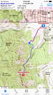
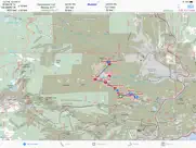
Record tracks as you hike, even in the background. View them on the map with a Trip Timer & Odometer.
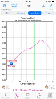
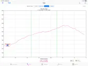
View elevation graphs of your tracks & routes. Show date, time, average speed and % grade. Measure the area inside a closed path.
Mark waypoints precisely using topo or satellite maps, place names or addresses, geotagged photos or by projecting from a known point.
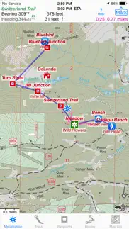
Set a quick GoTo waypoint or a full route & see the heading, direction, distance, elevation change and Estimated Time of Arrival at your destination & intermediate waypoints along the trail.
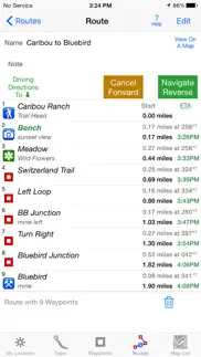
Create customized routes using waypoints, recorded tracks, or imported GPX, KML or TCX files. Advanced route editing.
Send waypoint, route, track & map list files via AirDrop, eMail, Messages or iCloud Drive.
View the sun & moon position, rise times, & set times for any date & place on earth.
Send data to other apps such as Google Earth.
TOPO MAPS AT NO EXTRA COST
USA: Newest US Forest Service FSTopo 24K maps
USGS 24K maps for all 50 states, Guam, Puerto Rico & the US Virgin Islands
USGS 250K & 100K (63K for Alaska) maps for all states
Canada: National Resources Canada 50K maps for all areas south of 50° latitude. For Alberta, British Columbia & Newfoundland, coverage extends to 54° latitude.
Download using WiFi or cell service. Our maps are optimized to download faster & use less storage memory. Store up to 2200 maps to use in the wilderness without cell service.
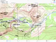
These beautiful richly detailed offline topographic map images stitch together for seamless coverage across map boundaries.
Print & Share map images overlaid with waypoints, routes & tracks.
Measure distance and direction between any 2 points.
USE THE UNITS YOU PREFER
Miles, Nautical miles or Km
Feet or Meters
Degrees, Degrees/Minutes, Degrees/Minutes/Seconds, UTM or USNG-MGRS
°True or °Magnetic
HOW TOS
Comprehensive Help in the App
Online Manual on iHikeGPS.com
Email developer: lwjames@iHikeGPS.com
WHAT OTHERS SAY
“I am VERY impressed!!!…It pretty much blows…, my previous fave GPS app, out of the water. Your track recording features, fast map downloads, and well thought out interface make it a real winner. It's very sophisticated software, and makes my iPhone just about as good as $600 Garmin… Actually better, in a lot of ways”-John in OR
“Perfect for anyone camping, fishing & hiking, it'll provide great detail when you need it the most…for anyone who takes the great outdoors seriously”-David's review
“thank you for developing IHIKE GPS…what a great product it is. I am impressed!…I use it hiking, biking, skiing & Jeeping”-Ammon in CO
DEVICE REQUIREMENTS
Use iHikeGPS on any iOS device even if you don't have a cellular data plan for it. iPhones & WiFi+cellular iPads support full navigation. WiFi-only iPads & iPod touch can view maps, but require an iOS-compatible external GPS receiver to show your location & record tracks.
Join thousands of satisfied users who rely on iHikeGPS for their outdoor adventures!
😍 Do you love IHikeGPS : Classic Topo Maps app? Please share your friends!

Please wait! IHikeGPS : Classic Topo Maps app comments loading...
IHikeGPS : Classic Topo Maps 9.4.5 Tips, Tricks, Cheats and Rules
What do you think of the IHikeGPS : Classic Topo Maps app? Can you share your complaints, experiences, or thoughts about the application with James Associates Inc. and other users?
IHikeGPS : Classic Topo Maps 9.4.5 Apps Screenshots & Images
IHikeGPS : Classic Topo Maps iphone, ipad, apple watch and apple tv screenshot images, pictures.
| Language | English |
| Price | $4.99 |
| Adult Rating | 4+ years and older |
| Current Version | 9.4.5 |
| Play Store | com.macgpspro.iHikeGPS |
| Compatibility | iOS 12.0 or later |
IHikeGPS : Classic Topo Maps (Versiyon 9.4.5) Install & Download
The application IHikeGPS : Classic Topo Maps was published in the category Navigation on 12 February 2010, Friday and was developed by James Associates Inc. [Developer ID: 351499178]. This program file size is 11.74 MB. This app has been rated by 53 users and has a rating of 4.3 out of 5. IHikeGPS : Classic Topo Maps - Navigation app posted on 07 March 2024, Thursday current version is 9.4.5 and works well on iOS 12.0 and higher versions. Google Play ID: com.macgpspro.iHikeGPS. Languages supported by the app:
EN Download & Install Now!| App Name | Score | Comments | Price |
I use this app daily on trails in Colorado. We're continually improving it to be even more useful! This version adds the ability to view a weather report for any location. What's new in iHikeGPS when compared with other available USA and Canada topo map apps? • Real Navigation Power: Unlike other apps that simply display waypoints and routes on a map, iHikeGPS empowers you to do real navigation to those waypoints and along those routes while receiving crucial information such as Estimated Time of Arrival, current bearing, and remaining distance and elevation gain to intermediate and final destinations. Use other available apps to find trails to hike. Use iHikeGPS when you are on the trail and away from cell service. • With iHikeGPS, you receive the very latest US Forest Service maps at no additional charge. These maps show many new and more accurately placed trails, numbered Forest Service roads, buildings, and other important details. They show forested areas and inholdings so you know if you are on Forest Service land or private land. None of these maps are older than 2015, and many are even more recent. If you venture into Wilderness Areas or National Forest Service lands, these USFS maps will be invaluable to you. Don't settle for hiking apps which don't offer US Forest Service topo maps, or which say they include US Forest Service maps, but actually just give you the outdated 2013 versions. • You can view an elevation graph of your tracks and your routes with speed, % grade, and nearby waypoints shown on it. • You can create, import, edit, and navigate both on routes based on a recorded or imported path, and on routes based on a series of waypoints. • iHikeGPS' s code size is kept very small by efficient programming, so in an emergency you can download it easily even over a weak cell connection. • The current version of iHikeGPS runs on the latest devices and also on older devices with older versions of iOS , all the way back to devices such as the iPhone 6. • There is never any confusion over what maps you have available offline. They are clearly listed by USGS quad name and shown on an overview map. • Check the App Privacy section. We don't know who you are when you are using iHikeGPS. We never send your current location or your recorded track to our servers. Hence we cannot and don't use your location data. We cannot and don't provide your location data to anyone else. Unlike other mapping apps that profit from using your location data in ways that do not keep it private, iHikeGPS maintains the highest level of data confidentially.
| App Name | Released |
| Speedometer Simple | 18 November 2014 |
| ParkMobile - Find Parking | 04 April 2010 |
| Google Maps | 12 December 2012 |
| NAVER Map, Navigation | 01 May 2009 |
| ParkHouston | 05 May 2017 |
Find on this site the customer service details of IHikeGPS : Classic Topo Maps. Besides contact details, the page also offers a brief overview of the digital toy company.
| App Name | Released |
| MilGPS | 01 December 2010 |
| Blitzer.de PRO | 03 August 2022 |
| Holding Pattern Trainer | 16 August 2011 |
| Ski Tracks | 05 April 2010 |
| Wasatch Backcountry Skiing Map | 01 October 2013 |
Discover how specific cryptocurrencies work — and get a bit of each crypto to try out for yourself. Coinbase is the easiest place to buy and sell cryptocurrency. Sign up and get started today.
| App Name | Released |
| B.A.A. Racing App | 25 March 2024 |
| Amazon Prime Video | 31 July 2012 |
| DramaBox - Stream Drama Shorts | 18 April 2023 |
| Snapchat | 13 July 2011 |
| CapCut - Video Editor | 14 April 2020 |
Looking for comprehensive training in Google Analytics 4? We've compiled the top paid and free GA4 courses available in 2024.
| App Name | Released |
| MONOPOLY | 04 December 2019 |
| Merge Watermelon for watch | 04 March 2021 |
| True Skate | 18 October 2012 |
| Arcadia - Watch Retro Games | 18 December 2019 |
| Shadowrocket | 13 April 2015 |
Each capsule is packed with pure, high-potency nootropic nutrients. No pointless additives. Just 100% natural brainpower. Third-party tested and validated by the Clean Label Project.
Adsterra is the most preferred ad network for those looking for an alternative to AdSense. Adsterra is the ideal choice for new sites with low daily traffic. In order to advertise on the site in Adsterra, like other ad networks, a certain traffic limit, domain age, etc. is required. There are no strict rules.
The easy, affordable way to create your professional portfolio website, store, blog & client galleries. No coding needed. Try free now.
IHikeGPS : Classic Topo Maps Comments & Reviews 2024
We transfer money over €4 billion every month. We enable individual and business accounts to save 4 million Euros on bank transfer fees. Want to send free money abroad or transfer money abroad for free? Free international money transfer!
Battery Saver - on Trail or close to Home. My location is determined by automatically receiving multiple satellite signals. Therefore iHikeGPS works completely with my iphone while being in (or not being in) Airplane Mode. I have used it 10+ years. My Hiking days are less each year (age 81); iHikeGPS is my most used GPS App. Now it is easily used to help find my car in a large Parking Lot! Thank you to the authors for creating and updating a wonderful and useful App, without a subscription fee.
Great app.. Have been using the app for several years and it works and has been a great resource in off road and backcountry. I would love to see two additions to the app. 1. Be able to show on apple CarPlay and 2. The ability to move in and out from high resolution maps to 100k by just zooming with finger motions instead of having to change maps.
Lost. I can’t get it to track. I want an app to leave a trail; breadcrumbs. Even on the blank page it left a straight line. Downloaded a map and nothing. Press the track button and it stays on off.
Good stuff. I’m passionate the outdoors. I seem to use paper maps and iPhone/iPad apps weekly for hiking, backpacking, bikepacking, backcountry skiing and exploring in my car. I have maintained a paid Gaia subscription for years, I’ve used low cost/free GPS mapping tools, location enabled PDF’s, etc. Still iHike is the simplest, fastest, most intuitive app of them all, with also the lowest power consumption and best map download facility. These days I only use Gaia on my Mac at home for planning. The map choices on iHike are ‘limited’ to USGS and USFS topos, but in real life these are the ones you need for backcountry travel.
MapNut. Accurate and fairly intuitive. Imaging is excellent. If you need more help, the video tutorials on the website are very clear and easy to understand. Would highly recommend you view them first although I went right out the door and got it done. Lots of easy to use and useful features that are not on some other iPhone mapping apps. Mid-priced at this time compared to some other map apps. Couldn't quite give it 5 stars because unlike MotionGPS, it will not track when the screen is rested to save battery power. Would like to see the track transmitted graphically instead of just GPX file, as an option. I have MacGPS Pro and it went straight to and opened that application when I emailed it to myself. It's a keeper. Good job!
Great, until a bug. I loved this ap. Now the “my location” no longer shows my location. Please fix!
Not useful. Good screenshots but bad resolution. Not good for hiking or anything else.
Superb access to official US maps. This superb app faithfully accesses and displays the official high-res and carefully-stitched scanned US topographic and Forest Service maps, just as if you bought the paper version. The hsophisticated user will appreciate these maps as the ones available from, and therefore vetted by, the US Govt. It is not, nor intended to be, an application to find the latest shopping mall by driving. However, noting that mountains, valleys, rivers, lakes seem not to move around very much on human lifetime scales, if you are out avoiding that shopping mall in an area with no signs of human intervention, nothing could be better for getting around, and you won’t mind the lack of frequent map updates of the latest gas stations. It will, of course, enable you to find your car after the day or week or whatever long hike. I wish it were harder to use—I’m kinda jealous of my favorite hiking areas and this app may actually encourage more hiking. The manual is very nicely sorted so you can figure out what to do to access all the features. My only gripe is that it should add a display for speed in the GPS coordinates area. If it displayed speed I would give it 6 stars. The very best hiking app. Period. Not so much unneeded bells and whistles. Best help interface ever. Really nice downloads.
Works with Magellan ToughCase GPS and 1st gen iPod Touch. I wanted a GPS that used the USGS topo maps, instead of the expensive and proprietary maps the major GPS manufacturers sell. I was able to find the Magellan ToughCase GPS add-on at my local Apple retail store. I put in my 1st gen iPod Touch (Magellan does not list this as a supported model, probably because the iPod is the wrong shape/size) and iHikeGPS works great. Screen redraws are a bit slow when scrolling around the map, but I expected that. It would be nice to be able to generate a route, and maybe I can, but I didn't see it listed in the tutorials on their web site. But it has what I really needed, topo maps at 24K and the ability to record tracks and export for use in a Mac mapping program, so good value for the dollar, and less expensive than a new mid-range GPS, with better capabilities and screen.
My favorite hiking app!. Simple and easy, doesn’t kill battery, loads fast, works great.
I LOVE this app. My goal is to locate rock art sites on a map as I hike, so I will be able to find them again. With this app, I was able to stand at the site and mark its location precisely. It works perfectly. I still need to learn how to transfer the map data to another computer, but I'm guessing this will also work well. Unfortunately, with all this capability, the app is a real power hog. They give you suggestions to preserve as much power as possible, but my solution was to forego the routing function by turning off the IPad between sites. It boots up quickly for recording my location, and then I turn it off,again until the next site.
Lots of room for improvement. As others have noticed, the lag in panning or zooming a map is horrible, and then you are apt to be scolded by the app for pressing while the sceen is refreshing. Sheesh! Several other map apps deal with this ok. Another interface gotcha is the main map window. Any pan will kill the autocenter. If you close and reopen the app, it centers in some default spot. Ah, you think, I shall press the My Location button and all will be well! Nope. You have to quintuple (!) click on the map. Charming. I like the profile idea and showing your route on the map. But in practice there are flaws. Profile is oblivious to gaps. I got only 1/10th of a one mile ski on the profile though I left the app on. Looked at the profile and there were these funny steps, plus total distance was wrong. Would prefer gaps estimated by distance between points on gap sides (which are obvious on map). This will be tricky to fix when profile not cleared between different places. Maybe a smart splitter to make new profiles if different day or more than xxx km apart? Adding Forest Service maps a huge plus in much of the west, and arguably the best reason to get this. No mosaiced maps, only one at a time. I found the map addition process cumbersome and non intuitive despite several options for finding maps.
Works great!. I have been using this app for years to record gps tracks on the USGS topographic maps. It works wonderfully! I am using my Garmin units less now. You do need to bring along external batteries to power the iPhone gps on a long day trip. My only quibble is that it does not record enough data points for a long bike ride, so you must remember to save your data log every few hours or it will start to overwrite itself without warning when it has reached its maximum number of points.
The best I've used.. This is by far my favorite GPS app for hiking. It just does more things right than any other GPS app I've used: accurate georeferencing, the ability to add waypoints by lat/long, and the ability to save routes for use on other devices. If it needs one feature to become everything I need from a hiking-oriented GPS app, it would be a graphical compass (beyond just the bearing and heading in degrees). However, there is one major issue I have with this app: after I need to restore my device for any reason, this app offers to redownload the maps I most recently had on there. This is great. However, if the download fails for any reason (including the device going to sleep), and at least one map has been fully downloaded, then the app forgets that any other maps were ever downloaded. I would like a better implementation of the redownloading of maps after restore (perhaps something that detects if the batch download was interrupted? Perhaps the addition of something that keeps a certain "set" of maps on your device, and the ability to have multiple sets, and these sets are just stored as metadata like waypoints and routes are?). I'd also like to see something that allows batch downloading of multiple maps (rather than one at a time like it is now), and graphical management (like, for example being able to delete maps or groups of maps based on their location overlaid over a Google map, rather than based on the name of the quad)
Great!. I really appreciate how this developer makes features available that other apps charge a premium or subscription for. I've owned several such apps, and this one is my favorite.
Pretty good for the price. For the average person, this is a great app for hiking. You can print maps, but you may not print maps with UTM or lat long grids on the edges. That is a problem if you want to print a map to take with you along with your compass. If you could print with location grids, you can navigate with your compass much more effectively when your phone fails you in the wilderness. Notice I said will fail you. DO NOT TAKE THIS PROGRAM AND PHONE AS YOUR PRIMARY NAVIGATION IN TO THE WILDERNES. You want a map and compass for your primary in a wilderness enviroment. THis is great to take with you once you know how to use it. I would give 5 stars if you could print with utm grids on the maps, but you cant. Make no mistake, I like this, but it is not a professonals program.
IHike 24K maps. I feel I have to combat the only review of the current version that you will see. Look guys/gals this is an amazing app! I have many GPSrs and iPhone geoapps. This is the only one that lets me see off line where I am at 24k topo map scale and the topo maps are free! I was out today examining some small mountain roads and related entries to regional preserves. My Garmin 60CSx was loaded with the Garmin Topo USA series of 100k topo maps for this area. My 3rd gen iTouch with Magellan Toughcase was loaded with all the relevant 24k topo maps that I downloaded for free from iHike app. I used both simultaneously. The Garmin 100k scale maps did not show the small roads that were evident on the 24k scale topo maps of iHike. Both Garmin and iHike agreed on the total distance covered. Both Garmin and iHike exports agreed in route and distance when exported to Google Earth. Garmin does a better job in showing "true" elevation gain because it includes a barometric damper to the altitude variations from point to point tracking while my Magellan case does not. Bottom Line: Use both because the free iHike 24k maps are really accurate compared to the Garmin 100k maps on your GPSr. It's like having a 24k topo GIS system in your car or backpack.
Works great for my needs. I didn’t want a social/sharing app. I just wanted to make a gps track and see a topo without needing any signal while hiking. I can download all the maps I need when I’m home on wifi.
Just AMAZING!. I read several reviews before buying this app. I have also downloaded 5-6 apps that claim to be helpful out on the trail. None of those come close to this app in terms of functionality and reliability. Even though this app takes a little while to figure out, I tested in on a long weekend hike in an area that is in the middle of nowhere with no cell signal whatsoever. We backpacked and hiked in a mountainous area with no trail markings. The GPS combined with the topo maps were like a Godsend for this hike. I loaded several waypoints using coordinates from Google maps into this app priori to our trip and it saved our day by helping us stay on track. This is a MUST HAVE app for all backpackers/hikers. The iPhone 6+ upgrade was perfectly timed for our hike. Well done and thank you!
Great app for hiking. Great app for hiking!! I am reposting this review after using the app for day hiking in Rocky Mountain National Park. I have an old Garmin Vista that has been my mainstay for years, but for day hiking in the US I will leave the Garmin at home from now on, or have it my pack as backup. My iPhone4 in the front pocket of my hiking shorts made quite accurate tracks. I had no problem with battery life on hikes up to 6 hours. I simply choose "Always" on the tracks page, and then turned the phone off to save power. I estimate that on multi day hikes I could go 2-3 days on one charge and longer if I turned off the tracking feature. Of course the iPhone does not have a barometer for altitude, but I found the GPS altitudes to be pretty accurate. I preloaded all the Topographic maps I needed for the park. When hiking iHikeGPS automatically switches maps when you cross map boundaries. Some trails we used are not current on the USGS topos, but I found tracks for those hikes on the web, loaded them in MacGPS Pro on my Mac and created a series of waypoints that tracked the main features of the trail. I then saved the waypoints in GPX format and uploaded to iHikeGPS.
Pretty good app. When in cell service I just use google maps, so this is exclusively for offline navigation. The maps are good, but being limited to 200 maps is annoying, also the way you select maps to download is annoying. Because these are 7.5 minute maps it takes a lot of them to cover a decent size region, but you have to select maps one a a time. I downloaded maps covering a broad area around where I live and hunt, and around places I like to go hike, but got to my 200 map limit. I wanted to have a large base area covered and then add maps as I go for individual trips. After taking the time to add them all I don't want to delete any... But I have to in order to free up room for any new regions. I have a 64 GB iPad, why not let me use as much space as I want to on this app?
Outstanding Hiking GPS App. If you hike or backpack using USGS quads this is the app for you! US and Canada Topos are included in the base price. You simply download the map(s) you need when on WiFi or Cellular Data and then you can use them where you have no WiFi or Cellular data. Downloading takes seconds. Several easy ways to find the map(s) you want. When you hike you turn on a "track" and it draws your progress on a map. The different Topos can be "stitched" so that progress from quad to another occurs with so margins. Also the track has a graph showing elevation profile. You can see total average speed and speed during a section of the track. Maps are very clear and easy to zoom in and out. App allows you to put Way Points on the map ahead of time to aid in navigation or to ID where you took photos etc. The help button is always present and touching it takes you to the section of help applicable to where you are in the app. The help is organized extremely well and put into tables. I've used a lot of apps and never seen help this well done. Even includes a complete listing of the dozens of symbols used on topo maps. All this for $8. A bargain.
Best GPS app for iPhone and iPad!!. I’ve used this app for 4-5 years and it’s much better than any map app out there! I’ve had Garmin GPS’s since they came out. This app with my iPhone is so much more user friendly than any of the Garmin models. Easy to download maps, works when you have no cell service, support is unbelievable. Twice in the last few years I’ve had a problem (user error)and my emails were answered within a couple of hours to resolve it. Can’t go wrong with this app!
Does everything better than anybody. I have used numerous mobile gps apps, and none comes even close to iHikeGPS. Being able to download topo and forest maps, for free, by WiFi before a trip is great. But if you are stuck on the trail outside your downloaded area, you can still get maps with even a minimal cell signal. The app handles waypoints, tracks and routes with ease, imports and exports gpx and kml format smoothly, and has the best built in help file I have ever seen. And everything can be edited right on the app. It’s all you need for gps.
Very useful!. During a recent vacation trip up the Maine coast, even though we weren’t hiking, my wife and I found iHike GPS invaluable for finding and navigating little back roads and discovering the interesting sites along them. We were doing a lot of birding, and promising spots are often easy to pick out on USGS maps. But there’s no way I could have bought printed topo maps for all the territory we covered, often without planning ahead, and using paper maps in the car would have been quite inconvenient. Having dozens of them on my iPad (at no cost!) was fantastic. iHike GPS is a wonderful addition to my software arsenal and vacation travel toolkit.
Nice upgrade to solid product. IHikeGPS was awesome before and the Feb 2013 upgrade is even better. Stitching maps is a great new feature if you want to see your whole route, and the help pages are now complete and easy to follow. I use the app for bike commuting, and it's most useful to see where you've been and how much up and down you're doing on the different routes. You can easily export tracks to Google Earth and see them in 3d if you want. I love the trusty old USGS maps, and this is a great way to carry them in your pocket wherever you go.
Worth the price. Used on a couple of day hikes so far, worked well. Was especially useful for assessing total distance traveled, and for emailing waypoints and tracks for import directly into Google Earth on another computer. Be aware this app is no substitute for a proper and up-to-date trail map. The two maps I downloaded were over 30 years old and showed very little of the trail systems in the parks I visited. For example the Mendham NJ quadrangle was last updated in 1981 from a 1976 aerial survey. Finally, map handling appears processor intensive; each pan or zoom-out involves a 1-2 second delay on an iPhone 4s. I'm OK with all this however, no regrets.
Best topo ever.. I’ve owned this app since 2012. Phenomenal. Solved many an off-road quandary. Recommended to over a 100, that download on the spot. It’s Helped find stuck and lost people, planned epic adventures. Every time I start to think “other than iPhone”? iHike is what keeps me Apple. (So it’s sold for them a 4s, 5s, 6s+, 7+, and XSMax since I bought in on my 3g, lol) I could go on for hours. The only way this would improve? Is if we had CarPlay/Projection Manager stuff. And trivial, but I’d sacrifice a small portion of my screen for an active Gps driven speedometer indicator.
Confusing maps approach. I downloaded this app based on favorable reviews. But so far it’s confusing. I’m a GIS professional and programmer so don’t think it’s just me. I downloaded a few 24K maps near me, then downloaded a few 100K maps surrounding those. Then I wanted to download some 24K maps within the areas of the 100K maps. So far I have not found a way to do so. Tried various taps and buttons but no luck. Maybe once you’ve downloaded a coarser scale map you cannot also download a finer scale map of the same area. I also can’t zoom out very far— pinching out only zooms out to a pretty local scale, so can’t see the context. EDIT: I see the developer wrote a rather snippy reply to my review. Guess I must have touched a nerve. I'll admit that I did not thoroughly read all the Help material before posting the review, though I did consult it more than the average user would have. I mentioned that I hadn't found a way to download a 24K map in an area where I had already downloaded a 100K map. That was based on the instructions to tap the page in order to download a map. Subsequently I did find how to download the 24K map after you have another map for the same area. But it's not obvious: click the "Map List" tab along the bottom, then click the "+" icon at top left, then tap "Satellite Map Locator", then zoom/pan to where you want the new map, then tap the "+" in upper right, then tap the "Add USA 24K USGS Map". Whew. The approach for maps here is completely different (not "a little different") from any of the other GIS/GPS apps I've used (which is quite a few). It's not because it's raster vs. vector based, since other GIS/GPS apps also use raster/tile based maps. I guess my bottom line is that if you're willing to put in some time to learn the quirky interface, the app can be useful for limited areas of travel. I still wonder about zooming out, though--I can't zoom out beyond a radius of about 3 miles with the 24K map view enabled, or around 20 miles with the 250K map view.
Only useful for finding yourself. This is a terrible app if you want to look back at you hikes. All tracks are the same color. I used this app all weekend, we went on six different hikes. Some as short as two miles one that was eight. The screen is a total mess of pink lines leading out from camp. I can't make out one from another. It gets three stars because of the ease of downloading maps and its functionality as a gps. Do not buy this app if you want to permanently track your hikes. This app needs the ability to stop a current track, name it save it, color both the track and individual waypoints, save those tracks and then have a list of waypoints or tracks that I have saved and be able to display those saved tracks or waypoints on the screen while recording my new current track.
Great App for Hiking. Although I agree with a couple of the other reviews regarding the lack of being able to select for download more than one map at a time and the lack of seamless adjoining of maps, I really have enjoyed using this app while hiking in the Canadian Rockies and the Cascade Mountains in Washington State. And I really like that you can download maps in advance for when you are hiking in areas with no cell coverage. For now, I am only going to give it 4-stars because I would like to see the following features added in a future version: - Ability to select more than one map at a time for download. - Ability to use iCloud to sync Waypoints, Routes and Maps between iOS devices. - Add an option to display a compass overlay (or at least a true bearing display) so that you can align the displayed map with True North. - The ability to sort Waypoints by distance from your current location. - Show the distance and bearing to each Waypoint from your current position (when on the Waypoints page.) Otherwise, great app!
Great Hiking and GPS App. iHikeGPS is a great app. Importing/uploading .gpx files is easy as is adding new waypoints. The best thing though is the access to maps, USGS and US Forest Service for the US and National Resources Canada for Canada. Just tapping the screen brings up the available map options and dowloads are fast, usually just a matter of seconds even using cell data. The maps stitch together seamlessly for comprehensive coverage and their resolution is incredible. And they’re all free! There’s also an extensive Help section making the app just an all around excellent product.
Don’t leave home without it. This is one of my first apps. I was just beginning to understand the ropes of navigating with a hand held gps. They were fascinating to me. Then I discovered IHikeGPS. Works offline, download and store USGS and USFS maps, create waypoints, no hassles with subscriptions or purchases. One inexpensive payment and actual product support from the author. There is a learning curve. It’s not steep. It is important to read the instructions and not assume to much. Works on the ground, in a plane or car. This app shows me where in at and where I’m going.
Maps are extremely old.. Maps for my area are well over 35 years old. Does not reflect federal turnpike that has been in service for over 35 years. What other state/federal infrastructure is missing.
Fantastic app-watch support please. I have checked many other gps apps. Still think this is the best. Still longing for watch support. I have used it for years and love it. Please, please add watch support. Make it an in app purchase. Very high quality topo maps for no charge. Great support from the developer both for the app and for the topos he hosts on his server. Make sure your compass is calibrated before using the app. If your compass can't calibrate check Settings/privacy/location services/system services/
Best hiking app. Have used a variety of GPS apps. This is best for US and Canada users because it’s easy to import/export GPX and other common formats, it uses the very familiar USGS/USFS topo maps at all scales (1/24K to 1/250K), and once the needed maps are downloaded it needs no mobile data connection. It also has no subscription fees and no strange proprietary maps. It would be nice if it also took geolocated PDFs, but so far so good.
Amazing amazing GPS and Topo App. What an incredible app. I downloaded it for my iphone4s not knowing anything since there were no reviews, but it has blown my mind. Worth 10x more for anyone who likes to leave the trails. We used it to waypoint between several gps coordinates and created a trail along the way. We then used it to navigate us back at night. It worked perfectly the whole time, even when we had no cell service. It tracked our entire hike to within 20/30 feet!! I can't wait to use it much more in exploring my local mountains.
A little fix?. It’s a great app. I like how as you scroll it moves from one contiguous map to another. How hard would it be for you to change the map title to reflect the new quad it’s on? Thanks.
GreatApps!. I purchased both iHike and iSail apps this year and they are both TERRIFIC! They were both easy to download and easy to use. I used iHike in Colorado while horseback riding in the Gunnison National Forest. 80 miles of unmarked trails in an area that was "off the grid"! No problem for this app. I downloaded the maps prior to the trip and the app worked flawlessly. I used the app extensively to track my path into the forest. With the path recorded, it was much easier finding my way back home! I still brought hard copy maps and a compass as backup, but the iHike app was my principal source of navigation. 9 days of riding on unmarked trails and I never got lost. Thanks for making such great apps!
Waypoints. I like everything about it except I would like to be able to create waypoints using the elevation plot. Great to get this feature.
Clunky, funky, tedious, painful.. The user interface is pretty bad. To download a map takes 5 steps and after a single quad has been downloaded, you have to start from ground zero to get the next map. Tedious and DOS-like. The index map SHOULD show a grid of maps and the user simply selects the quad or range of quads and click install. After the maps are installed you can only view one quad at a time. If your trail or destination crosses quads, you have to leave the current map and go to another. Hardly elegant or practical when trying to navigate along a map boundary or want to see a larger overview. This is the only mapping app I have seen that doesn't have the capacity to mosaic adjoining quads. The only time I use this any more is when I need to view USFS quads. My go-to topographic app is TOPO. It is cheaper, quicker, WAY more intuitive and much more robust. There may be better apps out there, but iHikeGPS isn't one of them.
Awesome app. I tried several GPS apps like GPS Kit, MotionX-GPS, etc and I believe this is the best one for hiking, backpacking, mountaineering...my main criteria is the quality of maps. All of these apps have to buy licenses to get the maps and iHike uses USGS and US State Forest maps which none of the other apps use and the topo maps lines are a lot more clear for me to understand. Regarding app navigation I find all the apps not very intuitive and iHike is not exception in this regard but with a little bit of practice & reading the help, I can find my way around just fine. I did a GPX import and the track and way points imported without issues. Overall, it's an awesome app.
It works but..... Good app for hunting, hiking or even tracking. I like the fact that you can enter shared coordinates and track your own with different icons. There’s are plenty of default roads and waypoints that help your progress and the offline maps are a plus. I would like to see more map options, especially with the offline maps. I don’t always know what the terrain ahead of me looks like, so a more detailed map would really help out there. Also, when I am tracking from one grid to the next, the downloaded map just disappears until I double tap on the white area, then the map I just left disappears. I need to screen shot and send my progress for work and that is a real problem if I can’t show where I was at. Within the last few days, the app won’t find my location. It’ll just take me to the last map I downloaded, not my current location. I need coordinates of where I’m at. Not very useful anymore. I might delete app and pay again for something else that is more reliable.
Excellent for hiking. This app does what it does extremely well: work as a general-purpose hiking GPS with USGS topo maps as a background. It seems to find the correct map for the location fast and easily, it doesn't drain the battery terribly quickly, and it generally does the job right. I've run across two fairly minor glitches. First, in my hands the application crashed when I asked it to display a waypoint on a map before I had loaded any maps. This obviously is a minor problem, since the app isn't very useful without maps; I only happened to run across it because I was trying it out before I had time to download any maps. Second, some of the maps in my area (Maryland) seem to load with their margins, instead of trimmed. This means that the maps do not come together seamlessly. Instead, when one is close to the edge of one of these maps, the app displays only the map one is on, not the neighboring map. Annoying, but it only happens with certain maps. Overall, I'm extremely happy with this app, and I think it will probably replace my hiking GPS.
Great app. This app allows preloading maps so you can be well prepared for no cell phone service. The app has helped me get un-lost multiple times. It is also easy to use.
Nearly Great. I love having up to 500 USGS topo maps available on my iPad. Currently I have around 200 maps downloaded which covers all of the Sierras and the SF bay area that I am interested in. Next I will download southern Utah topos for when I hike then in two months. The topo maps are are copies of the current USGS maps and are as current as the official maps are. If the maps are old, complain to the USGS. The topography has not changed but roads and trails may be out of date. For the maps that I have compared I can not see any difference between the iHikeGPS maps and the original, printed USGS maps. Why not 5 stars? I would like to be able to see more than one map at a time. I was expecting that I would see seamless maps while scrolling just like I can with their other product, MacGPS Pro. Instead I need to double tap in the area of the new map, which then gets displayed while the old map disappears. Next, downloading many maps is more cumbersome than necessary. I was hoping to draw a box over the areas where I would like to download multiple maps. Or at least a que where I could select multiple maps to download. Instead I must pick them out one at a time.
I Love This App. This is the best app for hiking that I have yet to find and I have tried several. I have used James Associates desktop MacGPSPro for years and uploaded routes to and downloaded track logs from my Garmin GPS. Now I can do the same with this iPhone app. It downloads USGS Topo maps in seconds over WiFi or a cellular data connection. And it can be used offline to follow a route and create a track log. Waypoints may be created within the app or downloaded to it in .gpx format. What more could anyone want. I have used it for local hikes and for navigating National Wildlife Refuges during a recent trip to Florida. I have never had any problem with it. It has met my requirements and exceeded my expectations. A terrific app at a very reasonable price.
Maps Seem Poor. I couldn’t believe I bought this! The map quality is extremely poor.
Worth Every Penny. Seriously love this app!! Very accurate and reliable. Track log showing elevation, distance, and time/date stamps is really nice. You can easily email/share track logs....just tried it today. Great for tracking distance traveled and for visually seeing your track on the map. I also use it to capture/create waypoints and view current location on the map...flawless. This app pretty much does what my $500 Garmin does...in terms of what I primarily use it for. I use his Mac GPSPro software on Mac OSX and absolutely love it! And this guy is as good as it gets when it comes to responsiveness and support... I cannot emphasize this enough...see for yourself. No affiliation....just a very satisfied outdoor enthusiast!
Lacking organization. This app is amazing works great while hunting in areas with no service what so ever. The only thing I see that would make this app better would be a way to store maps and waypoints in specific folders for the different areas that may be downloaded. Would be 5 stars otherwise.
Did you know that you can earn 25 USD from our site just by registering? Get $25 for free by joining Payoneer!
rubbish app. no metric, no non-US
Imagine you at your best. All the time. Picture yourself at your sharpest and most productive. Your most alert and focused. Your most lucid, creative and confident. At work. At play. In every area of your life. Add Mind Lab Pro® v4.0 to your daily routine and uncap your true potential. Buy Now!
I am very upset !. I am very upset that you do sell something on the canadian store that does not have canadian maps .
Québec. Dosent work un Québec
Great app. I just discovered and downloaded this app on my iPhone and iPad. It is awesome period.
Adsterra is the most preferred ad network for those looking for an alternative to AdSense. Adsterra is the ideal choice for new sites with low daily traffic. In order to advertise on the site in Adsterra, like other ad networks, a certain traffic limit, domain age, etc. is required. There are no strict rules. Sign up!
The App I Have Been Waiting For!. Rich feature set and life-time access to maps make iHikeGPS a bargain. I have used James Associates GPS products for nearly 10 years and I can attest to the unwavering devotion to development and support of the superior GPS products.
Great hiking app!. Really great application for hiking. I've used in remote High Sierra to Joshua Tree, always had accurate GPS readings. Also good for elevation tracking and waypoint markers. Compass integration also super helpful. All topo map downloads are free after buying the app and are automatically stitched together to create larger map areas. I always bring a paper map, but generally this is what look at most while on the trail.
It does what it does vey well. This app does what it is supposed to do, and does it very well. It is also a nice complement to the Mac app by the same author. I am particularly pleased by the quality of the GPX files it produces. I have other apps that record my walking routes, but none that do so with the kind of precision that this one does. That said, there are two things I need to see added before I can rate it five stars: 1. Graphically show my compass bearing on the map, so I can tell when I’m oriented in the right direction. 2. Make the OpenStreetMaps available as an option. At least in my area, those maps provide much better information about trails, and are more up to date. [The quads for my area are decades out of date and show none of the trails!]
My go-to TOPO Quad solution. If I need topographic maps, this is where I go. It’s on all of my devices. The maps are rendered beautifully. Other apps have more gee whiz features, but this is the app I use if I want to actually read the map.
Awesome app!. I have used this app twice at the Daniel Boone National Forest (in the Red River Gorge area). There are some places here with a well deserved reputation of being impossible to find unless someone who knows how to get there takes you. Well, I have made it to two of these destinations now by using this app. If you are a hiker who likes to go off the beaten path you need this app. We've all spent lots of money on our hiking and camping gear and seriously this will be the best 10 bucks you ever spend.
Wonderful GPS mapping App. i Hike GPS just gets better and better. So many free map sources, the ability to really zoom in on the topo maps, and all the extras make this a great deal. My current favorite feature is being able to pull up photos I have taken on my iPhone and iPad I have taken before and then navigating to those photo locations. Great for finding outcrops and fossil locations in the field. Too bad I can only give it 5 stars!
Wonderful!!. I can't believe this app is free! Best one out there for off road navigation. We use it to plan, execute and document our adventures in the middle of nowhere. So easy to use yet so complete. None of my paid apps have provided as much. Bravo!
Maps are from 1929!!!. Nice interface and easy to use BUT the maps are from 1929!!! 1929 folks! These don't show man made lake that have been here for the last 35 years because the maps are from 19 freaking 29!!! To the developers who just nabbed $8 from me... You... Are... Evil.
Crash crash n crash some more. The ui on this is a direct port of the iPhone the instructions are even formatted for the iPhone. Beyond that it crashed 4 times in less than a mile before I gave up and shut it off
Very cool. I've not tried a lot of GPS app, but I'm impressed with this... Check it out!
Great GPS/mapping/distance app. I use this for 3 primary purposes: 1. When hiking I can see where I am and navigate to where I want to be. 2. When running it tells me how far I have gone. 3. When flying wildfire helicopter recon missions I can map perimeters and mark areas of concern. Works great with no observed glitches.
Great app, maps are old. I love maps, my degree is in Geography, and I worked in land survey when I was first out of college. This app works as described, only drawback for me is the maps of my locale are 30 years old, and a lot can happen in 30 years.
Wildland firefighter. I just starting using this App. It is the only App I have seen that really functions like a handheld GPS. It is easy to use and seems robust enough to handle waypoints and tracks. The quads are of good quality. I recommend it.
Very Good App. I am an avid hiker and I love looking at and playing with TOPO maps. This app is the best I have seen for maps. If you are looking for a good TOPO map app don't shirk at the price it is worth it 😄
Excellent hiking companion. iHikeGPS excels at providing offline topographic maps for hiking/biking, etc. It works great where cell coverage is spotty or no-existant. Although the interface has a few quirks, once you have worked through them it is pretty quick. I really appreciate having access to Forest Service maps. It is probably a limitation of the maps and not the software, but I would like to be able to zoom out further on the maps.
Almost seems like cheating. I have used this app extensively for backcountry navigation. Often I am where there are no trails. Compared to using a map and compass it feels like cheating. I always know exactly where I am and which direction I am facing. This app has saved me countless hours of wandering trying to figure out how to get where I want to go.
Fantastic. Handy app. Hope developer keep on developing it. Is it possible to utilize iPhone 's co processor(motion sensor) to save the battery while logging path? Another problem, Sometimes if you switch to camera to other app and then lick the screen, the logging will stop until next time you open the app. Wish to fix this.
Fantastic. I have owned many gps units, garmin hike, sailing, auto, aviation. I love adventure. This is my favorite hiking gps. All I need & want. My location, route, tracks & waypoints on perfect usgs quad maps. Before a big hike, I'll find someone's excellent route/track on the web (gpx), open & inspect it in ihikegps and it will always know the on trail distance to either end. And just before the adventure, I email (or now Bluetooth send). The waypoints & map to my wife's gps. For a multiday hike, I take a 3oz battery for a couple iphone recharges.
Works really well. Regarding the complaint about dates from another reviewer: The maps are recent. Many maps say "1929" under the title because that is when the datum was established. The date of publication is in the lower right corner.
Works well but maps need help. I know the usgs and forest service maps are not under the developer's control. They are not great for many areas. There are competing apps that use other map sources that are superior. "Trails" uses much better maps but the app itself is a dog. "Gaia" uses better maps and the app is snappy. I am hoepful that iHike will get it together and use some open source alternatives that are superior as an option in addition to the curremt sources. Or license some and make it an optional in app purchase. Until then, cheaper apps have better maps so iHike is tough to recommend.
Lame at best!. While this app has possibilities the inability to transfer .GPX files from the computer to the app using iTunes USB File Sharing makes it just about useless. Not even worth being a free app much less costing $7.99!
Great app!. I have been an early adopter of the MacGPS family of products where either I'm sailing or hiking with the assistance of these solutions. They continue to improve and are always the best I've seen on the market at a reasonable price. Keep up the good work!
Not Worth the Money. The main reason I purchased this software was for the graph that tracks elevation change. It is very erratic and unreliable. I got readings that changed up & down 20ft - 30ft just standing in one spot. Sometimes it can't even get an elevation reading so it is just blank. Also, you have to download individual topo maps into your phone. While trying to do so, my connection timed out several times. Once you finally get it to show a topo map, there is nothing on the map that indicates where you are. It's just a topo map. And if you want to drag the image around with your thumb to see what else is around, it takes about 30 seconds for it to generate the new image.
I don't write reviews, but.... Making an exception in this case. I can do with out a lot of apps, this isn't one of them. Take it everywhere and utilize it often, on and off trail. Great app and very responsive development team. Would love to have access to BLM maps but other than that this app is a steal. Great job guys, keep it up.
Very Disappointed. The USGS maps used where published in the 1970s or earlier. Example: there is a 6 lane highway (990) here in Amhearst NY built in the late 1980s that is not on these maps. I have a Garmin GPS hand held that is 10 yrs old and the maps are more up to date and much more detailed. I'm sure there are much better apps for hiking and out door activities.
Not as I expected.... I just purchased this app and try a few... Then I realized that there is only one kind of map format. Compare to other app which has more map choice depend on the trip. Also to make way pint, have to fill some in filling page, instead of just drag on the map and tap like a other app.
Fantastic app!. I was having trouble with a map not loading and had sent an email to the support team. They got back to me quickly and were able to resolve my issue (user error). Great for exploring new areas on my mountain bike!
lag time makes it unusable. I've used MotionX and wanted to try an app that would work well with laptop software so I'm trying this for the first time today. I'd planned on downloading MacGPS Pro this afternoon but I'm going to wait until I'm convinced this app works. Today I've been using it in an urban setting so the maps aren't optimal but the lag time is unbearable. For me that's a deal breaker.
Finaly a gps app that works the way I want.. I can hardly wait too try this on the ipad. The processor can't quite keep up on the road but it should do fine while hiking.
Exchange users beware. As a long time MacGPS Pro user I am happy to support this developer. I was disappointed to discover AFTER paying for this app that never auto lock is disabled if you sync with an exchange server. This renders track logging, for which I wanted this app, pretty much useless to me. Not the dev's fault but irritating nonetheless.
I really like this App!. I'm impressed by the accuracy. We live way out in the country with spotty cell reception, but I can use this app in its gps mode and it works well. It follows a route accurately, I mean it traces over the road I'm driving on to a T and it can read UTM (a real plus). It located our land survey markers spot-on. The maps render quickly. Worth the price.
Great for hikers. Lots of useful features. Works well while offline (like when you're out in the woods).
This app rocks!. I use this app for tracking my trips on road or trail, and love that I can transfer to the computer and overlay in google earth also. Plus to be able to bring up downloaded maps without cell or data access is great for the middle of nowhere map reading and trail finding.
Best Navigation app on the app store. I've bought and tried several other (more expensive) iOS hiking navigation apps, and this is by far the best one. Good map orientation, ascent profile, and route history support. Also unlike other apps this one doesn't make you register for an account.
Maps load very slowly. Over the past few years I have purchased a lot of maps and software from James Associates, Inc and have been quite pleased. However, this iPhone/iTouch software in its present form is a waste of ones 8 bucks. This is because the map screen updates are very very slow when you recenter the map or increase/decrease the scale. Hopefully the developers will fix this problem, because the way it is now, the program is pretty much useless for me.
Off the Grid app!. Love this app, great for Kayaking and land navigation. Maps are a bit out of date but I think that is on the USGS more than a developer issue so with that I give it 5 stars. The other numerous GPS apps I tried failed face down in the field, this one was amazing. Great Job!
Waste of money. I can't believe I paid for a app that I still have to download individual maps for basically every grid square I an trying to look at and the maps available are like 100 years old. To me a GPS app should already have maps available. I have free apps that are more user friendly
Excellent. I have used iHikeGPS for a couple of months now. It has been fantastic and helped us on about 5 Anza Borrego desert trails that are sometimes ambiguous at best. Have used without issue on iPhone and mini iPad. The USGS maps download quite fast, and your location/tracking is superimposed on the map. Great asset for hiking.
You will love it. I've had this app for a number of years and it continues to be my go-to backcountry navigation resource. No cell-service required-just gps reception which is very reliable. My only wish is that all my devices could sync through iCloud to retain all my routes.
A Fabulous App!!!. This app is brilliant . . . and the tech support, if you need it is fabulous. I wouldn’t have any other app but this for the hiking book I am writing or for while I’m just hiking for the fun of it. I’ve tried a few other hiking apps, but they don’t compare with ease of use, clarity or they didn’t offer tech support or manuals, so they were useless for me. The creator of the app is patient and VERY helpful and doesn’t mind all my questions or confusion. This app is brilliant. I don’t know the creator of the app btw, so I’m not biased!). Buy it, you’ll be delighted, Julie
Incredible App. This is an incredible app. It is easy to use, full of useful features, and comes with outstanding technical support from the author, Mr. Larry James. This app can be used in place of a gps device. Great product!
Rock Solid. This is a rock solid app. I have been using it since version 1 and it has only gotten better. It has never let me down and I have relied on it for many many days of traveling in the back country. Having access to real USGS maps is a real plus in my book.
Never crashed for me!. I had this app on my iphone 3G and now on my iPhone 4. It never crashed on either phone. It was excruciatingly slow on the old phone but works perfectly on the new one. Now I plan to buy an iPad and expect it to be even better there. But you have to know how to read topo maps, DUH! But once you figure out how to d/l maps and set it up correctly, it is amazing.
So far, so good.. I just downloaded it and will test tomorrow. I'm impressed so far!
Mr Sheridan Goutermout. If it wasn't for this app on my iPhone I would not go on the treks I do in the northern woods . It's easy to use , accurate and I highly recommend it to anyone who ventures into the woods.
Awesome App for Hiking. This is the best 8 dollars I have ever spent. This App helped me to navigate through 72 miles across Sierra Nevada, Fresno to Pone Pine. My phone was in airplane mode all the time and I had enough battery to use this app for 3 days. If you would like to have a GPS, this is the way to go!!!!
Good app, could be laid out a little better. I like the offline browsing of maps and being able to load and unload to save space. Also you can use Forest Service maps which are more detailed than the USGS ones. The only thing I would like to see is when scrolling the maps it would be seamless instead of having to load the next section because I run a hiker service (Trail Angels Hiker Services) through the White Mts. In NH and Mahoosucs in ME. And need to scroll through several maps. overall it gets the job done and I hope they improve it.
Excellent!. We have had the prior version for about two years. We use this app frequently for hiking, canoeing, and biking. It has helped us make decisions on quite a few occasions. The price is right, and I like that there is no ongoing fee. Once we got through the initial education, it has been easy to use. I've recommended it to several friends. One of them has a fancy dedicated GPS, yet bought iHike and likes it.
Outstanding. Just used this app in Platoro, Colorado with my family for a week. Amazing accuracy. The trail was difficult to see in a few areas so when I opened up iHikeGPS it showed us where we were in relation to the trail. We were only about 25 feet off course to the right. We were able to easily get back on course. Elevation and distance traveled was a lot of fun to keep track of.
1929?. The 1929 refers to a projection, not when the maps were last edited. These are the standard usgs topos. I use ihike and MacGpsPro to mange my gps data. It is amazing what you can do with the ihike app, it is almost a mobile GpsPro. Kudos!