Air Navigation Pro App Reviews
Air Navigation Pro App Description & Overview
What is air navigation pro app? Discover our flight planning & real-time navigation app for free for 28 days!
- Everything you need to fly around the world
- Plan your flight in a few minutes
- Fly relaxed with up-to-date information
Air Navigation Pro is a high-quality flight assistant app for pilots worldwide. Benefit from the following main features:
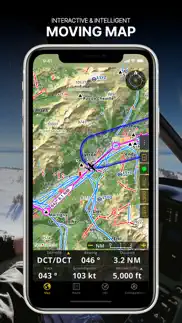
MOVING MAP
Plan and navigate using our interactive moving map. Choose between aeronautical charts, satellite or our vector map as a background. On top of that, the moving map displays waypoints, NOTAM, obstacles and airspaces from our comprehensive, always up-to-date worldwide aeronautical database. Tap on any waypoint directly on the map to easily create a route. Personalize the values shown on the navbar to have exactly the information you need: altitude, vertical speed, bearing, distance to the next waypoint, ETA calculations, etc. Choose the airport departure and arrival procedures for your route to have them also displayed on top of the moving map.
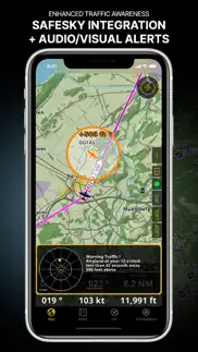
ENHANCED TRAFFIC AWARENESS
Get visual and audio alerts in all languages for nearby conflicting traffic. Choose your preferred traffic icon between generic, aircraft or TCAS symbols. Your safety is important to us, which is why we partnered with SafeSky to ensure our users have live traffic data during their flight. Benefit from the native integration with SafeSky included in our new Smart Lite, Smart Classic and Smart Advanced subscriptions—a two-in-one package!
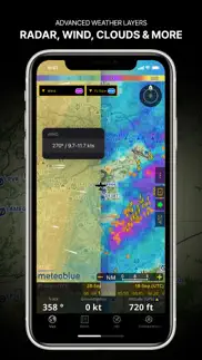
ADVANCED WEATHER LAYERS
In addition to the basic weather reports & forecast of winds, TAF/METAR and GAFOR for your flight in the Briefing section, subscribers of the Smart Advanced plan can activate see-through weather layers on top of the moving map. Available layers include rain radar, wind, pressure, clouds and rain, visibility, gust and for Germany, Switzerland, Austria and the Balkans, we also have GAFOR. Tap on any point on the map to see the weather information for that area. Review the weather forecast for up to three days ahead.
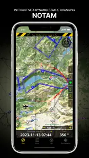
NOTAM
After creating your route, set the departure time in the future to have the moving map display the NOTAM active for that specific time. NOTAM on the map change color dynamically based on their status.
SMARTCHART
Our cutting-edge SmartChart is a highly detailed and intelligent vector-based map that adapts to your needs, providing you with adequate information at any zoom level. The SmartChart optimizes the display of shadows to easily distinguish between valleys and mountains, and the text remains perfectly aligned, guaranteeing optimal readability. Including the latest significant improvements with forests and detailed airport information.
ELEVATION PROFILE & 3D VIEW
Enable the profile view below the navbar for enhanced situational awareness of the elevation ahead of you or along your route. Choose the corridor width between 0 to 5 NM and overlay options: airspaces, NOTAM, obstacles, wind components, populated places, etc. Switch to the synthetic 3D view for additional terrain information, plus an artificial horizon with altitude and vertical speed indicators. The 3D function can also be used to pan around while preparing for your flight. Activate TAWS on the moving map as well as on the 3D view.
AERONAUTICAL CHARTS & APPROACH CHARTS
We offer the most extensive worldwide catalog of aeronautical charts, including the ICAO charts. Have the georeferenced approach charts displayed on top of the moving map or the 3D view.
BRIEFING
Prepare your flight with our briefing section by creating documents with NOTAM and weather charts & stations relevant to your planned route. Optimize time by creating an aircraft profile which will be used in the Briefing section to pre-fill for you the ATC Flight Plan and calculate the W&B.
AND SO MUCH MORE!
Please note that WiFi-only devices do not include an internal GPS receptor; for these devices, an external sensor is required. Refer to our user manual on our website: www.airnavigation.aero for more information.
😍 Do you love Air Navigation Pro app? Please share your friends!

Please wait! Air Navigation Pro app comments loading...
Air Navigation Pro 8.3.350 Tips, Tricks, Cheats and Rules
What do you think of the Air Navigation Pro app? Can you share your complaints, experiences, or thoughts about the application with Xample Sarl and other users?
Air Navigation Pro 8.3.350 Apps Screenshots & Images
Air Navigation Pro iphone, ipad, apple watch and apple tv screenshot images, pictures.
| Language | English |
| Price | Free |
| Adult Rating | 4+ years and older |
| Current Version | 8.3.350 |
| Play Store | ch.xample.Airnav |
| Compatibility | iOS 13.0 or later |
Air Navigation Pro (Versiyon 8.3.350) Install & Download
The application Air Navigation Pro was published in the category Navigation on 06 January 2009, Tuesday and was developed by Xample Sarl [Developer ID: 301046060]. This program file size is 194.28 MB. This app has been rated by 545 users and has a rating of 4.5 out of 5. Air Navigation Pro - Navigation app posted on 08 January 2024, Monday current version is 8.3.350 and works well on iOS 13.0 and higher versions. Google Play ID: ch.xample.Airnav. Languages supported by the app:
EN FR DE IT JA NB PT RU ES TR Download & Install Now!| App Name | Score | Comments | Price |
Happy New Year! Thank you for your continuous support for another year! Check out what's new in this version: - Map Annotations: Now, you can highlight, draw geometrical figures and write with a marker directly on the map, allowing you to create your own data like user airspaces. Activate it on Map Options - Guides and work in Edit Mode. - Enhanced Map Resolution: We've boosted the resolution of the vector map at high zoom levels, ensuring a clearer navigation experience. - Improved Dark Mode Handling: Switch effortlessly between Light, Dark or let the app adapt automatically. Find the new Color Theme menu on Map Options. - Seamless Cross-Platform Synchronization: Enjoy a smooth experience between your mobile device and the new desktop version! Start the year on the right track with our first update of 2024, because great journeys begin with great navigation!
| App Name | Released |
| Blink Charging Mobile App | 08 October 2022 |
| EVgo EV Chargers | 17 October 2017 |
| PlugShare | 07 March 2011 |
| LAZ Parking | 21 December 2018 |
| KakaoMap - Korea No.1 Map | 27 February 2009 |
Find on this site the customer service details of Air Navigation Pro. Besides contact details, the page also offers a brief overview of the digital toy company.
| App Name | Released |
| Trail Treker | 22 December 2016 |
| MilGPS | 01 December 2010 |
| IMotoneige | 02 December 2017 |
| AyeTides | 06 February 2019 |
| Wasatch Backcountry Skiing Map | 01 October 2013 |
Discover how specific cryptocurrencies work — and get a bit of each crypto to try out for yourself. Coinbase is the easiest place to buy and sell cryptocurrency. Sign up and get started today.
| App Name | Released |
| 05 February 2019 | |
| DoorDash - Food Delivery | 10 October 2013 |
| 06 October 2010 | |
| Amazon Shopping | 03 December 2008 |
| TikTok | 02 April 2014 |
Looking for comprehensive training in Google Analytics 4? We've compiled the top paid and free GA4 courses available in 2024.
| App Name | Released |
| MONOPOLY | 04 December 2019 |
| AnkiMobile Flashcards | 26 May 2010 |
| Bloons TD 5 | 15 November 2012 |
| True Skate | 18 October 2012 |
| Geometry Dash | 13 August 2013 |
Each capsule is packed with pure, high-potency nootropic nutrients. No pointless additives. Just 100% natural brainpower. Third-party tested and validated by the Clean Label Project.
Adsterra is the most preferred ad network for those looking for an alternative to AdSense. Adsterra is the ideal choice for new sites with low daily traffic. In order to advertise on the site in Adsterra, like other ad networks, a certain traffic limit, domain age, etc. is required. There are no strict rules.
The easy, affordable way to create your professional portfolio website, store, blog & client galleries. No coding needed. Try free now.
Air Navigation Pro Comments & Reviews 2024
We transfer money over €4 billion every month. We enable individual and business accounts to save 4 million Euros on bank transfer fees. Want to send free money abroad or transfer money abroad for free? Free international money transfer!
Dingaan. Really the app to beat for simple navigation planning and information. The support is excellent and updates and fixes proves the point. The app is constructed in a simple intuitive fashion. Keep up the good work!
Can’t accurate location in flight.. Can’t accurate location in flight.
Region discrimination like most apps anyway. This app is amazing if you live in a first world|well developed country. I used it through out my training in south Africa and for that I give it 5 starts however when I moved back to Kenya map options are limited and the only available ONC chart is from the 1970s hence lacks a lot of current information. Developers should consider adding more maps for such said countries
Great start. This application is impressive considering it is using gps for the direction ind, alt, VORs, and speed indicator. GPS on the iPhone isn't going to respond as smooth as your garmin but it works. Although it may be difficult to use true compus data for this app due to the fact that you would then have to mount the iphone perfectly in the plane, it would still be a great option. One other suggestion is to add an email option for exporting the flight plan and add frequencies to the airport info when you click on the airport icon on the GPS map. Also would be good to show radial in digital representation instead of just analog. Nice job. I like it. Hope to see some additional features soon.
Great Work!. Well designed and easy to use. Great for VFR flight. The cost for sectional chart is less the a dollar. It desplays usefull info on one single screen, from fligh plan to moving map (live sectional chart), to instruments. Great price too. Overall, it is the best air navigation product in the market, today!
Great VFR app. This is a great VFR app for a very reasonable price. Out of the two things I missed, one has now been implemented, the scratchpad in the lockscreen, which is much more clever than the one found in e.g. Foreflight. The only other thing I wish for is the ability to customize the instrument layout. I would for example want to have a screen with some notes, where I could write down dep/arr info and keep that visible all the time. Plus to rearrange the other items on the instr layout to just have the data I want there. Other than that, this is just a great app with great potential.
Not ready for primetime. This program is incredibly buggy. You can not rely on it to operate when you need it, therefore it falls into the realm of junk ware,and definitely not worth the hefty price tag. The software coding is extremely poor and everything runs very laggy compared to other gps mapping program. Something is wrong in the way it handles GPS tracking. Without a waypoint database his program is useless for flight planning. It's worth $1.99 and that's all until they get it working right. The map store is a great feature though, but everything else is bad. Save your money and skip this program until they revise it.
Worked fine until the recent update. App has worked fine for years. It recently updated, and now it crashes as soon as open it. Sometimes it shows the what’s new pop, up, but it freezes, then eventually crashes. Now I can’t use it at all. Sent message to support. Still waiting for response.
Lots of bugs, bad support. I do not recommend this app. Many (most) of the VFR sectionals will not install in the app, including the areas where I live and travel most. For whatever reason it will not plan a route longer than 1300 miles. LOUSY support. Looking into something else going forward.
Too bad. Used to be a great app. Low cost. Nice features. But the user interface, especially as it applies to getting charts, obstacle data, etc., is beyond confusing. Maybe the translation is suffering, but it’s almost incomprehensible. I’ve been a user for many years, but no longer. Also, the user manual is many versions old. Almost useless. Too bad. It used to be a good app.
Good. Good app
Just one thing. I love this app, and have been using it for many years. One thing I would ask is for a faster way to change maps. It requires 3 clicks now with hard to use menus. I would make it one click. Here is why it is important: of you fly VFR, you may find yourself having to switch between maps mid-air. When I fly helicopters, I use CVFR maps (which are used for low altitude general aviation routes), but sometimes the ATC will instruct me to fly based on helicopter routes, which are different and only listed in a specific map. Moving between maps should be easier to allow you to make that switch. Thanks!
Air Nav Pro. Used this week in the Piper worked OK. Need to add Airspace to the maps and get rid of the Turn Indicator on main page and add larger font for Tracking , Speed, and ETA. Would be a nice feature if you could turn off NDB's and VOR's on display, also, quick way to pick recent waypoints would a benefit. For the price makes handy backup or with added features would great for rented aircraft that doe not have GPS installled.
Very lovely app but recently....... Immediately after updating my iPad mini to the latest IOS 8.2 version I could no longer use the Airnav Pro app on my ipad, it doesn't just respond anymore. I think there has to be an update of the app for the new IOS 8.2 version. Will be grateful if you guys could work on that as soon as possible to enable users like me continue to enjoy the benefits of the app. Thank you.
great app.. best air navigation on iphone that i tried. I love the way you can overlay the free geo maps, and the ability to add your own custom waypoints. one thing they need to improve is that the frequency information for some airports is missing, otherwise I would have given them 5 stars. However, consider this application only as an in-flight navigation system. It's really weak on the flight planning side. For weather info consider a different app like aeroweather. Very quick response by email from customer service (important also). BTW, I read some reviews that complain about not having heading or distance information in flight, elevation data, and ability to select which waypoints to show. All these are available! But some require configuration or loading additional database. One thing I was disappointed to see in the latest version (4.2) is that rendering the geo maps is slower than the previous version (4.1). Not that it is a big problem. It still finishes the rendering in a couple of seconds, but looks like the speed optimization that they are using in 4.2 is working in the opposite way.
Useless without subscribing. Useless without $30-$45 subscription. “Free to try” means 2-week trial = no subscription = no utility. I think you can find the same features free from other sources. This is a nice package/presentation but seems weak for the price.
Maps. The maps never downloaded
Wonderful apps. From Capt Deen Islam. It’s very useful and accurate apps. I am using it for last 9 months for my helicopter. I am thankful to the developer. All the best wishes.
Iran. I wish , Iran had 3D information and danger o restricted area in coloring option 😭
Less data than Neighbors Nigeria. I have a yearly subscription to Nigeria. No airspaces, no approach plates no maps. Do not waste your money if you are working in Nigeria. They have the latest AIRAC just busy with more important stuff I guess for the last 3 months. Have a look at the neighbors Malabo. Even they have airspaces showing. The country I paid for a yearly subscription, no data. I used to have the South African version. Much more up to date. This is why I give them two stars, instead of a one star rating.
Baaaaaaaaaaaaaad&very Baaaaaaaaad. Due to deleted Iran ONC & Elevation charts in package.
Very good!. I have tried several apps and this is the best one even though I can not take advantage of the many features this one has due to my country's lack of technology. Single engine land, private pilot
NOT FREE. Fraud, not a free app, just a free trial, that’s not free. Should never have been on informer as a free app. Shame on you.
Disappointing support. I am a paying customer of the app, support is virtually useless, the app basically only support a few external devices for ahrs and ads-b. When i asked for support with the one (Stratux) i use which btw is one of the most used in the world the denied support and sent me to the public forums where the device is hacked to emulate one of the few that airnavigator pro at the expense ofmissing barometer altitude and other features. Really dissapointing for a service that i am paying almost 100 usd per year. I do not recommend it and when renewal time comes will look for an alternative like Foreflight.
Excellent app with a few minor improvements required.. 1- impossible to calibrate the artificial horizon while in flight (or when engine is on) as it is too sensitive. 2- compass gives false reading when on artificial horizon mode. (keeps on turning,,,) 3- maps- will be helpful to be able to get google maps, or other local maps, with higher resolution, as an additional layer. Other then that - excellent app. I bought the Garmin 695, and don't use it, since this is app is up and running....
Do not get this. It's not useful without subscription, and the price come close to or enen exceeds many other apps if you pay for subscription. I couldn't find avway to get refund as well.
Has potential. This program has potential. Would like to see for improvements: 1) Choice of what countries to load- ( I only need one-not all) 2) Choice of font/screen colors-I could not read the screen at all in the light 3) A direct to button and course line would be nice Nice to have something like this.
FIX IT!!!. I did The software update 8.3 on my ipad and now I can't get any satellite signal. I use The bad elf antena, in The bad elf app it works ok, but when I use it in The air Nav Pro it does not work. The antena link stay in yellow and never turn in green I know many people having The same problem
Cool app with a few issues. Really great VFR app with a few issues I discovered once I took it flying. The lack of good weather info is the biggest one. I am using the app in the US and the QNH is given in hPA, which cannot be used to set the altimeter. TAF is typically missing and the weather info remarks are often formatted in a rather difficult to read way. A weather overlay is needed with different parameters such as wind and precipitation. Radar would be good and the app eventually needs to support ADSB. For now I’d like to load this weather info while still on the ground and then use it offline during flight. Also there is a lot of info missing from the A/FD. I’d like this app to provide all the info including an aerial picture of the airport. The route display using custom waypoints should show more info on distance, estimated fuel, etc. in the regular view and not just in edit view. And finally I’d like to easily measure distances while en-route. One of the great features available is the easy scratch pad. It also seems that while this app is cheaper to start, it adds up quickly with a high granularity of chargeable items as opposed to a bundled subscription.
Best Amoung Few. So far the best of only two aviation moving maps available for the iPhone. But still seriously lacking in functionality when compared with what you can get for the Palm. Need to add terrain, airspace, attitude, customizable database, flight planning functions, and pertinent nav info to the map screen (ground speed, ETE, cross-track, etc.). FlightMaster for the Palm should be the model. Looking forward to future improvements.
USA sectionals display fuzzy. GREAT APP! .1 version has some needed chgs. Revision to fuzzy maps... Deleted everything. Re-downladed app and maps and maps are clear again. The USA sectionals when zooming down to a 6 mile setting display properly but you see very little around your plane. Zooming out one level more produces a fuzzy Vfr sectional that is unreadable. If this is fixed then it's a great update otherwise it's unusable.
Complicated. Not easy to use at all.
Very Useful European Aviation App!. Great App for planning and in-flight use for navigation, airport selection and many other features. This is the App for use in Europe as it contains good maps for VFR and most of the IFR structure waypoints. I would like to see the programmers continue to add other features for European use (IFR ELA charts, smaller scale VFR maps) but overall much better than their competitors who do not currently have any navigable maps for Europe.
ADS missing. Not compatible with SkyRadar Raddena. Rest of app is very good
The Best Bang For The Buck. This is the best iPad aviation app I have ever seen. The amount of information available is staggering. I am going to be mounting my iPad mini to the control panel of my aircraft and use it as my primary flight display. The app has even worked at over 40,000 ft. In a Beech Jet 400. It matched the aircraft FMS and GPS down to the tenth of a knot! The altitude feature is equally impressive. Weight and balance calculation plus 3D real time terrain data makes for an app that will have all other GPS and app makers scrambling to catch up. It can nickel and dime you, paying for terrain data and maps but it is not so bad and you own the app! Do yourself a favor and get this app. You will not be disappointed.
Map Download Problem and No Support. I purchased Air Nav Pro and attempted to download the 3D maps. I need 4 maps total at this time, but only 1 will actually download. Three of the U.S. states that I need will not even give me the option to download. I have sent two emails to support, but have not gotten a reply back from either email. I would not purchase this app if you are wanting the 3D maps to load and work correctly, because there is no way to know which maps are actually available and which ones are not.
There’s Better Out There. For Free. If you need terrain awareness, this app does it well. Very pricey, and misleading when it comes to what’s offered for initial subscription. App usage is clunky and not very intuitive. Every feature add-on requires a separate subscription. Example. you have to pay $.99 for each flight plan(yes each, not to enable the function, but for each), need charts and access to procedures such as airport diagrams, approaches, those are all separate subscriptions, in addition to paying the basic subscription rate. I purchased a subscription, and have since turned off auto-renewal.
Doesn’t do what it is supposed to do. I downloaded air navigation since on their website it was saying that it supports Flight Simulator X. I did all the process, downloading the AirBridge on my PC as well. Set up, follow the procedure, activate my subscription, then went onto sensors to activate the FSX one... nothing. Only P3D and Xplane available. Ok, thanks for making me waste my time.
Great features! Awesome app!. I wanted to start using my iPad in the cockpit but didn't want a spend a fortune to get started. This app lets you use your iPhone as the GPS for your iPad, and it works great! I payed for the US Sectionals and tested and had great results. I started with a full charge on my iPhone and my iPad and flew for exactly 1 hour. Both the iPad and the iPhone were at 79% battery at the end of the flight. (my iPhone is a 4S and the iPad 2 was at full brightness). The maps worked well and the airport information was very helpful. I felt much more comfortable with this tool in the cockpit. Tested linking the app to X-Plane to learn the app and was very impressed. I'm much happier with this than my trial of Foreflight and I will continue to use this on every flight.
Excellent product. The features of this app compete with ForeFlight, Garmin and WingX. How ever if you use a flight sim and wish to log your flights and post to the web, this is the only one that I found could do it. The 3D terrain Modeling along with airspace diagrams on the elevation graph, make this app very unique. Great job, I look forward to future enhancements.
Mr. This is truly an amazing product and well worth having in the cockpit for situational awareness. What would be a nice enhancement would be holding patterns that one could select either over a beacon or any point on the map and using the current aircraft position, show the entry and the pattern either standard or non standard. Also using the speed, plot the course.
Great for Mexico. This app's pro version includes terrain data for Mexico! I looked for this for months. In the route planning mode you get a cross section of the route with altitudes - very useful for planning trips in the mountains. Inflight you see the terrain altitudes for the next 9.4 nm - a great safety enhancement. Great app. Just need to allow us to put instruments next to the artificial horizon.
Hi. First let me have especial tank for your best app, then if it’s possible active 3D navigation and all airspace for iran country and airport en route chart. I have a suggestion : If it possible add an option for calculating intercept angle from one radial to another one
Now very good. Just installed latest update and there is now a course window that is displayed when you tap on the HSI, VOR or ADF. The course can be fine tuned by tapping on the lower left or right of the instrument. I now give it 5 stars. The app is now great and it keeps getting better. Much more useful, now.
Awesome app... Five star potential.... UPDATE: added a star... Sectionals updated! Thank you! Great app. Does some really practical functions in a clean way, lots of information at your fingertips. I've used this only a little in the cockpit myself... (new pilot) Usually i have my 10 yr old son run it... Why only 3 stars? Easily fixable. One star for better documentation, it appears the doc is for the iPhone not iPad (?). The other star... Updated US Sectionals, I emailed a request for the updated ones, weeks ago, still waiting. Not sure they understand they're updated every six months. We (VFR pilots) need current sectionals to be legal. The $0.99 price for the sectional is great though! Gladly pay it every six months for several of them... If they're current. Wish list... A super simple Checklist tab.. A list like the waypoints would do. And maybe a scratch pad.. Where we could jot down times, or squawk codes. Great work. Worth the price! Thanks so much...
Used to be good, but now it bites.. When I bought this app one could download sectionals one at a time for 99 cents. Now one must buy the entire data base for $10. When you only need one sectional, it just adds to the cost and hassle factor of flying. Using air nav for your sectional was not perfect, but it worked, and with some neat features. Now one must put up with that hassle AND pay $10. What is going to happen when the FAA starts to charge for data?
Glitch. How do I contact the programmer? There is a glitch with the identifier info tab in the route list. It continues to load the same info regardless of which airport I touch. If I look at one airports info then select another it continues to load the first info. How do I fix this?
Very good !. AirNav Pro on my iPad mini is my main navigation program and has replaced my old Lowrance Airmap GPS device . I also use this app at home to help with flight planning . I love this app and love how it doesn't require a subscription . Keep up the good work and thanks for all the updates and awesome features .
Unusable. Unable to open app because they just want you to pay, even though there is a “free trial”. I’d love to try out the app but I’m not going to put $58 in my iTunes account just to see if it fits my needs just so they can charge me in two weeks when I forget to cancel the automatic subscription. Sorry, I won’t buy into that.
Very Useful: Some Tweaks Needed. I bought this app to have back NAV on trip from Livermore CA to central TX to get a bird home I bought. It worked unbelievably well, with one caveat: I have difficulty in figuring out how to input a flight-plan. I have done it, but it is not intuitive and I would not attempt it in-flight. The D-> (Direct To) feature is simple and much easier than many other handhelds. I routinely fly cross- country with it open and running and follow my D -> trackline as backup to my Helm 650. As well the Nearest Airport feature is very easy to use. Highly recommended, just wish the flight-planning were easier to use.
Did you know that you can earn 25 USD from our site just by registering? Get $25 for free by joining Payoneer!
Aussie Maps Have Gone. This is an excellent all in one aviation app, but I can only give it one star. I purchased this expensive app for $40 on the basis it had in app purchase for Australian airservices charts. These charts have now disappeared from the in app map store with Bo explanation! Not good enough.
Could be better. I live in Australia and when ever I try and download the maps it never works, it would also be good if the VFR and IFR way points were on it
No Australia VTC, WAC & VNC?. Overall great app, but disappointed that the australian maps aren't available anymore. PLEASE BRING THEM BACK!
Far too Slow even on A5 iPad 2. This app lags both on iPhone 3GS & iPhone 4. Every time you try to move a map or click on an airport icon it just stalls, so not really very usable in an aircraft. Software in fact is good but the usability on an iPhone is poor. Purchased an iPad 2 and maps still lag badly. Software need a serious update to run smooth.
App crashes. This new version crashes immediately every time I want to open it. It would be great otherwise if only they supported the map downloads again for Australia which they did originally - suddenly no more!! - others can do it. See OzRunways - all maps including taxi charts, arrival and departure charts with Georeferencing, AIP etc. Without current maps I have wasted big $ as the app has been rendered useless. How can I get my money back?
++ Very Nice, update process needs improvement. Could be great ++. Nice product, my passengers and RFS (wife) loves it. Excellent for helping to understand NAV equipment and techniques as well as improving situational awareness. BUT Australian CTAF and Airspace is out of date for a number of areas I fly in. GAAP AIRSPACE HAS CHANGED TO CLASS D. Dangerously OUT OF DATE. The underlying airspace data needs to be able to be updated on a regular basis. I'd suggest a monthly inbuilt auto-check for airspace database updates. Keep up the good work.
Unbelievable. You pay good money for a product expecting it to do what it was meant to do and then it is rendered useless. The Aussie charts are what I am referring to. Complete waste of money for the short time it was useful. I have spread the word about this.
Needs updating. Nice app, needs the opportunity to update airfield locations and details eg YBLN CTAF is 127.0 and YPJT is now a Class D airport. If there is a way of sending you updates then I'll be more than happy to help.
Air Navigation Pro. First moving map for iPad in Australia. Expensive I guess but I finally can throw my Garmin 495 out the window....it was too small
Useless in Australia. I purchased and used it in Australia using charts available. These charts are NO LONGER AVAILABLE. This renders this useless in Australia. Until charts are available, don't waste your money!!
Not for Australians - expensive and full of issues. This iPad has no IFR or VFR maps available for Australia and thus is almost useless. The EFIS data is very difficult to download due to large file size, poor downloading design and very slow servers. It is also very expensive for what you get. Worst value aviation app I have tried. If you live in Australia DO NOT buy it!
Air Navigation Pro. This app is a complete scam and does not work. Do not buy it. They also will not issue refunds.
No Australia maps anymore. Was a great app until they removed the ability to buy Australian WAC VNC VTC maps.
Great App.. Wonderful to see an App of this type focused on aviation. Nice to have the ability to obtain maps here in Australia. Well done.
Best $ i ever spent. I was impressed by this app, even before the addition of support for Australian maps. Now that I can purchase wacs vncs and vtcs in air nav pro, I cannot recommend it more highly. Yes, there is a little lag while it loads maps, airspace and waypoints, but it is delivering more detail than many other dedicated aviation gps. I have an ipad1 and iphone4 and i am happy with performance on both.
Some features broken / not updated. Good product, very useful. Utility diminished of late as development and maintenance of certain features has lagged. For example, integration with Prepar3d is broken, so mission rehearsal / simulation is no longer possible.
No maps for Australia or New Zealand, come on guys what's happening!. I was impressed with the app up to now, when I tried to download some new maps for Australia and have not been able to do so because they are not available any more. What is one to do now for new maps. Unless the developer fixes this problem I may have to go else ware..
Fantastic. What a great app. Not for primary use but a potenially life saving backup and tons of fun
Great program. This is an absolutely fantastic program. It allows rapid flight planning, and in-flight tracking. It is the equivalent of large-screen GPS units costing 100 times more. Now I can import Australian aviation maps, it has changed my private flying for good. Thoroughly recommended. Worth every cent and more. Thanks to the guys for making this app! A must for all private pilots.
Mr. Awesome app, could not get any better, has made flying a lot easier. Hats off to whom ever designed.
Good little app. Very handy application and has the potential for so much more. If they could introduce airspace boundaries into the next version it would be fantastic.
Not practical. Don't waste your money. Despite numerous attempts and an email to the maker I couldn't download just one map. They are also doing something wrong as each map is over 500 mb
iPad crash on launch. Hi and thanks for a good ap. However second time I went to use 3.2 on iPad it crashed on launch and will not now start. Also, Australian airspace needs update. Cheers
Nice App. I have found this app very useful although on the iPhone 4 it tends to lag.
Imagine you at your best. All the time. Picture yourself at your sharpest and most productive. Your most alert and focused. Your most lucid, creative and confident. At work. At play. In every area of your life. Add Mind Lab Pro® v4.0 to your daily routine and uncap your true potential. Buy Now!
Poor coverage for Bangladesh. Very poor coverage for Bangladesh. Geography, terrain, network systems all prehistoric and not updated. Please do something and I’m telling this for years. Really shame.
Just Great!. I spent the cash and bought this app to have a back up nav tool where all the maps are stored on my iphone's memory. This way I can use the gps to navigate even while my cellular chip is turned off. Therefore allowing me to get accurate 'direct to' courses without using my cell phone data. When navigating on victor airways, this tool allows you to cross referencing your position with the aircraft VOR/DME. A little pricy, but a great great great tool to have in the cockpit!
Suggestions. Very good. Prefer than Foreflight and Garmin. I’d like to have some icons for specials waypoints, my flights , with helicopters, are more in bush, mainly fire-fifgting, far from airports. and standard aviation symbols.
I can’t updated only the aeronautical databank what I already paid. I can’t updated only the aeronautical databank what I already paid
Map downloads fail. The current version has issues with downloading the OSM (free) maps from the in-app store. You cannot download them other than through the app itself and the WiFi connection will not work well enough to complete a download. The developer tells me that the problem is in my network, although when I took my iPhone to the local Apple store, with their legendary 30 mb T3 connection, it still failed. Seems to be a problem with the app, not the network. Would appreciate a better way to download the maps and save them, as if you ever need to restore your iPhone or iPad, you lose the maps. The app is very good other than the maps. Lots of data and options. Have not used it in the plane yet for full testing as the maps have been an issue. Would love to be able to try it though.
Problem with version 4.1. Update: METARS and TAFS are now functioning normally! Excellent program! Thanks again. Outstanding wish list: Canadian Elevation database and geo-referenced approach charts. I have used this program for several years and wrote a favourable (5 star) review in June 2010. Since downloading version 4.04 the weather feature (METARS TAFS) has become inoperative. I sent an email 5 days ago via the Support email address but have received no reply. Please address this ASAP. ALSO, please supply Canadian elevation data. Canadian flier
Excellent App. Have personally used this to fly over 3000nm in both Canada and the USA, including flying into the Washington DC SFRA. It's extremely helpful and accurate. I would / have recommended this to many other pilots. Only a couple things missing which I suspect they may add. Airport diagrams. Geo-located would be nice A timer x 5. Ie fuel tank switch, etc click resettable. Auto gps connect, via Bluetooth with iPhone, you now manually do it, no big deal just a nuisance.
what about canada?. i feel ripped off after paying 37.99 when my friend paid 19.99 last month for the old version and his upgrade was free. why is there no airspace for canada? north east please! i dont have gps in my 172 and airnav with airspace would be awesome. please include this in the next udate
Excellent updates. I wrote a review on a past update that made the app slower and less responsive. Clearly the developers are listening and the updates since then have made this app better than before. This is a great tool in the cockpit and I recommend it to all my pilot friends. Keep up the great work!
simply amazing - basically replaces a $1000+ GPS system!. I am a "weekend warrior" private pilot, licensed in the mid '90s, just getting back into it after a few years off. I actually got my flight review and "re-curency" signed off today! After dloading the App a few days ago, and playing around with it at home thinking it was too good to be true, I flight tested this App today with my instructor and we were both blown away by it! The refresh rate on an iPhone4 was very good! For some one like me, that can't really justify dropping $1000+ on an aviation GPS, this is a perfect solution! I wouldn't necessarily count on it as a primary nav source, as per the "disclaimer", but for a solid back-up to good old chart reading and radio navigation, this is awesome!
Excellente application mais... Le nouveau catalogue de carte ne fonctionne pas sur mon ipad. Pas cappable de télécharger les cartes.
To goog to be true Trop beau pour être vrai. J'ai acquis cette application avec beaucoup d'expectative. J'ai rapidement déchanté. En bref, l'application est loin de rivaliser avec Foreflight dont je suis abonné avec version Canada-USA avec vison synthétique. Il y a énormément de limitaion dont le fait que les informations sol sont limitées. Il n'y a aucun détail sur la configuration graphique des aéroports pas plus que de suivit NOTAM. Cela étant dit, le coût qui, àprime abord parait allèchant l'est moins lorsque l'on considère que la version pro de base, ne comporte pas la version 3D. Il faut acheter plusieurs modules pour couvrir l'amérique du Nord et dépenser des centines de dollars. De plus, la carte n'est pas à jours pour notre région, transformé le 26 mai 2016 par le changement des zones de contrôles. Il faut aussi dire que la carte n'est pas une carte offciel de NAV CANADA et on y retrouve plusieurs incongruités comme le long de la frontière entre le Québec et l'État de New York et Vermont. En bref, une application venu d'europe qui a du mal à s'adapter à notre réalité. Finalement, le service après vente est plus qu’ordinaire, une demande faite le 28 août n'a pas encore reçu de réponse. Lorsqu'une demande est adressés à Foreflight, la réponse se fait rapidement, généralement dans l'heures ou le même jour. Très décevant, je regrette l'achat
Excellent app!. Excellent app! Need improvement for Canadian pilots. It would be great to have approach charts for Canadian aerodromes as well as more options on the map like weather, winds, etc.
Just amazing. I have just travelled on a 10 day trip from Canada to San Diego and back. The application is amazing. Very accurate. It makes it easy to navigate around class B. The only draw back is that I could not get the weather to update on the 3G network. Hopefully the Canadian VFR charts will be available soon.
Big deception. Loosing Gps signal, display map freezing, often loose speed display and need to reset. After 3 years I'M deciding to discard this app
Amazing app. You are getting the equivalent of a $1000 aviation gps for $50! Only minor issues are lack of 3d data for canada and no w+b calculator.
Keeps loosing maps. It would be good except for the fact that the app isn't stable. I keep loosing maps at different zoom levels.
Cheap but unreliable app. All maps are deleted with any iOS update. Map loading only work with the app opened in download window and then at 0.1 MB @ min when each map weight more than 100 MB. Low motivation of the technical team to solve problems.
Simple et facile d’utilisation.. Nous sommes plusieurs ici dans CHARLEVOIX, Québec,Canada à utiliser cette application qui fonctionne très bien et répond à nos besoins.
it. To start - the app is great ! it's not perfect, but if I had to give up this or the "real" one ( the garmin ), I'd give up the garmin. This is easier to use and they keep making it better. That being said, on the last update they added the ability to tune the VOR' and HSI one degree at a time ( very useful when doing simulated approaches in bumpy conditions ( are there any other kind ? ). Unfortunately, on that update my mileage scale at the top of the map screen seemed to be in Greek or something ( letters where there used to be numbers ) - something similar with the message box that pops up when setting the VOR/HSI/ADF degrees ). I'm quite disappointed that this latest version didn't fix this bug.........
Topo maps. Doing low level work,topo maps are great to use. Its been a month since some Topo maps have been missing even after downloading them numerous times. System confirms download is completed but no display.... When returning to the store, those maps are shown as not loaded. Developers need to be quicker to resolve those issues.
Excellent VFR tool. This product is competitive with Foreflight and even includes features not found in Foreflight, at less overall cost. For example VFR Nav Pro includes terrain profile mapping which is very useful for plotting routes through the mountains. It also includes SPOT-like in flight tracking to a website (limited to cell phone coverage areas currently). Also flight tracking playback, live time logbook entries, and weight & balance calculations. The ability to provide Heads Up Display mode, especially when paired with an actual AHRS (attitude, heading reference syst) unit is intruiging. The addition of Canadian VNC and VTA charts would improve my rating to 5 stars. In the meanwhile, the generic world maps and USA charts (reasonably-priced in app purchase) keeps it very useful. Although the VTA chart is not available, the DISPLAY AIRSPACE option shows all desired airspace boundaries and the controlling agency. (The appropriate frequencies to call would be a desirable addition). Of course the flight planning and GPS displays are excellent. Overall, it is an excellent tool for a Canadian VFR pilot (me). Now that Foreflight has the Canadian charts, I may need both apps and run two ipads!
Adsterra is the most preferred ad network for those looking for an alternative to AdSense. Adsterra is the ideal choice for new sites with low daily traffic. In order to advertise on the site in Adsterra, like other ad networks, a certain traffic limit, domain age, etc. is required. There are no strict rules. Sign up!
Nice app. Great app, but crashes sometimes on ios4.
Doble pago. Mis compras en la app al descargar el un nuevo iPhone con mi mismo icloud me cobra de nueva, base de dato y 3D, siendo que mi suscripción anula vence en noviembre del 2019. Si me pidieran arreglase eso les agradecería.
Version 4 MUCH improved. I have not found any problems whatsoever in this version. Works as intended, but still waiting on radio frequencies at smaller airports in USA.
a waste. This could be a good app except nav is true not magnetic Obviously programmer is not familar with air navigation. So this was $10 wasted. I should have read the comments first my fault.
The best. This app is every pilots dream! Adds tremendous value in every aspect. No brainer, buy it. Also, staff is very friendly if you encounter problems. And no, I am not an employee but really love this product and highly recommend it.
Aviation. This is a great tool! I like flying the sectionals on iPad lot better than a clumsy paper map.The touch screen information touch a airport an you are given info on it and airspace great for VFR.The Bad Elf or blue tooth GNS 5870 no jail braking needed.If it had Terran Avoidance with voice that would be great I could plug it into audio panel.Not ready yet to get rid of the Garmin 430 but this nice to have as back up and doing your flight planing! Add extended runways option great for lining up on approach
THE aviation GPS navigator to beat. I don't write reviews often but I felt compelled to write about this app. When I first tried the app at home I was already quite impressed with the feature set. However, there were a few little bugs, but nothing that would prevent use of the app. I actually contacted the developers thru email and they answered my concerns within a hour. They said that they knew of the issues and that a new version was already submitted for review by Apple. This app really came to life once I took it flying. I fly professionally and wanted a backup system in case of an electrical failure. I have been waiting for a dev to come out with an iPad offering just like this one. First of all, the pros: Very intuitive app. Menus are all very easy to access and set in a logical manner. I used to use a tablet pc before the iPad and let me tell you how frustrating that was. The interface is beautiful and I love the HSI presentation on the main screen. You can actually set two navigation modes in the same session. What I mean is that you can have the HSI set to one waypoint and the VOR of ADF to another. Very neat. Airports and navaids are selectable by tapping directly on them on the map. A menu pops up to give you the info on that particular item and then you can select DIRECT TO right from that menu. No typing, which make it super fast and easy to change destination or waypoint. You can modify the main screen to your taste. Nice touch. You can select north up or track up. Believe it or not that is a feature that is not always offered in apps like these. Flight time logging is a feature I though was a gimmick. The devs say that it will log your flight time automatically when you start moving and will sense when you are taking off, thus providing a block time and a flight time record. In the professional flying world, this is what we use. Not only did this feature work, but it worked flawlessly. What would be great though is if we could store tail numbers so that wee don't always have to type it in every flight. Sectional charts are of very good quality and are a steal at .99c. You can actually select and track radials by using the OBS on the HSI and VOR. Very nice feature for a GPS navigator. GPS reception is flawless on the iPad. I had this thing on my knee the entire time and even put it on the floor away from the windows to test it. Still had reception! So signal is no issue here. This app tracked accurately and precisely during the entire flight. I tested accuracy against a Garmin 530W. Cons: Database for fixes or intersections is non existent. This seriously limits what you can do as far as flight planning along airways. However, I am under the impression this is coming sometime soon. IFR enroute charts would be killer on this app. And a miracle would be approach chart support. Also, a "scratch pad" feature like in the FOREFLIGHT app would be nice for note taking. The search feature for airports and navaids is a bit weird. Sometimes you have to type the full 4 letter identifier and sometimes it will take 3 letters. And the search feature doesn't always seem to find what you are looking for. Perhaps I'm not doing something right. I'm not sure just yet. All in all this is a very well made GPS navigator. It's reliable and makes a great secondary nav option or as an emergency backup. Plus, you can get the iPhone version at no extra cost. I highly recommend this app and I am looking forward to the updates and I am excited about it's potential.
Complete & utter trash. Don't waste your money. I've spent well over $80.00 on Pro version plus 3D maps. Garbage. 3D maps are 3rd party software and will not load inside the program. Plus you cannot get a refund. This has got to be the poorest software purchase decision I've ever made. It's complete and utter trash!!!!
Problems. Beware, navigation is True Not Magnetic. So it is not useable except as a game.
Great App For Many Users. If you're flying in Western Europe and some other non-US locations (New Zealand, Australia, S. America) this seems like it could be a leading choice for a moving map navigation app. Loading the free openstreetmap.org maps, or paid aviation charts, for a variety of countries is very easy. I'm not going to review the app functions in detail - they all seem to work as advertised, both in the planning stage and in flight. For myself, I'm a low time VFR pilot in the US that mainly makes 2-3 hr. trips to build experience (and have expensive lunches,) and I still plot my flights on paper charts with the rigor that my instructor drilled into me. I thought I'd try AIr Navigation Pro as a GPS backup and for this it is very good. Transferring my paper routes is easy and monitoring my progress in-flight is reassuring. The Air Nav Pro instruments work well and are a great backup feature that I hope I'll never need. I often fly close to mountainous areas so I particularly appreciate the elevation profile ahead. So my niche is a low cost, lower function alternative to Foreflight or WingX. Here is my only grumble. When I purchased, the top in-app buys were 99c individual sectionals, but now one can only buy charts for the whole US, for $9.99. Because I live in L.A. I also need the TAC, which means second set of TACs, also for the whole country and also for $9.99. And they're updated twice a year. $40/yr in maps (at time of writing) is peanuts compared to the rest of my hobby so I don't mind, but it puts the cost of AIr Navigation Pro much closer to that of Foreflight. I don't own the latter but once I start venturing further from home it seems to have planning and editing features that more powerful and polished than those in Air Nav, such as fuel pricing on the map and a more logical way to add waypoints. Air Navigation Pro is a good app at a reasonable price that is great for Europe (where the app developer is based) and some other non-US locations. For low time US users it's a good entry to GPS moving maps but the pricing structure might make you consider alternatives.
Great app!. I'm simply amazed by this and other apps like it. Does anyone remember dead reckoning? I look forward to any updates. How can anyone not find this amazing?
Not very good. Waste of money. No guidance or help in how to use the app.
no no with ios 6.0. Excelent app, but messy with ios 6.0... I wanna go back to previous os! :(
Excellent. Excellent program specially for making flight plans and if you don't have VOR or DME its a good alternative. Worth every penny.
Flying in Thailand. Great App, thanks to the developers. I'm flying with it in Thailand and there is nothing comparable. Thanks Andy for the SUPER Maps.
Best app for experimental aircraft!. This is the best moving map and efis app in aviation today. Great graphics. Easy to use. Maps are clean, and so is the aviation data. Synthetic vision is way cool. Best app for the money. My requests... 1. Have a mini efis instrument on the instrument list! 2. Incorporate ads-b data (weather and traffic)
Good enough for me, but always hoping for more. I've been waiting a long time for an affordable flight navigation app for the iPhone. I've been using PocketFMS for the past years on a Dell Axim, and although PocketFMS has great features, I've never been too enthusiastic about the user friendliness. Add a sluggish Dell Axim PDA, in-flight crashes or GPS signal lost (and almost impossible to restore) and it was clear I needed something else. Let me start that I like Air Navigation Pro . It's easy to use and is very responsive. I don't fly that often, so I don't want an expensive solution with high subscription fees. Let me share my experiences after two flights, using a TomTom car-kit (this boosts GPS reception, made it easy to attach my iPhone against the side window of the Cessna 172 and the power cable ensured charging while flying). The good: - The interface is like you can expect from an iPhone/iPad app: easy to operate, finger pinch to zoom in/out, drag to move the map, etc. - The free provided airspace information and free back-ground maps are good enough for me. In fact, I find them more pleasant than PocketFMS. Not all information from a VFR map is there, but when I'm flying I don't care about where all obstacles are (I'm flying VFR, and see where I'm going; I always do a thorough flight preparation anyhow using official maps, so I know where to expect peculiarities concerning airspace and other need to know restrictions). - Anti-cluttering works nicely (better than PocketFMS IMHO). - Airspace filtering: you can set it to only show airspace within plus minus 1000 feet. Very convenient while flying. - Fast (on iPhone 4) - The app can be configured to act as a web-server. At home through your wifi connection you can access the app through your desktop web-browser and download flight details (logbook, breadcrumb trail which can be viewed in Google Earth, flight plans). - Stable. I have not encountered crashes (other than trying to connect to the GoVFR website, see below). The bad: - Version 3.5.0 should enable you to upload navigation plans from GoVFR.com. Doesn't work, the app just exits (note: I checked out GoVFR, but as it does not yet have airspace information for the Netherlands, it's of no value to me). - European flight maps (can be purchased) for use in Air Navigation Pro: outrageously overpriced (definitely not "for a fair price" as stated on the vendor's website). The US sectionals are indeed very cheap, but paying over twice the amount I pay for a paper copy of a given flight map (that I have only use for in the app) is over the top (compare: almost 40 times as expensive than a US sectional in-app purchase). - Selection of next way-point algorithm can be improved. For my first flight (with Air Navigation Pro) I was following a navigation plan that was a flight starting/ending at the same aerodrome. This also meant that the paths from and two were close to each other (ca. 15 miles apart). During the second half of the flight, visibility was rapidly deteriorating, so I decided to select "direct" to the airport. As the weather improved again, I loaded the original navigation plan back in. Air Navigation Pro selected the closest way-point, which was on the opposite leg, instead of selecting the way-point I was directly flying towards (I was aiming straight at it and also almost back on the original navigation track). This can easily been improved in a next version. - There is no link to i-Flyte, the checklist app from the same vendor. Although you can start Air Navigation Pro from the checklist app, it is not possible to do so the other way round. You can use Air Navigation Pro to keep running in the background, unfortunately the checklist app does not, so you always have to start from scratch. I expect to be able to access my checklists directly from Air Navigation Pro. Shouldn't be too hard to do. ...and the wanted (in other words dear developer: please please please add to the next version :-) - Add extensions to files downloaded through the web-server. E.g. adding .kml to a breadcrumb trail, would make it immediately recognizable for Google Earth. - North up arrow in the map. Although it is very easy to switch between "heading up" or "north up" displays, it is hard to tell where North is on the "heading up" display. - Flight plan construction: please add rubber-banding, i.e. enable dragging of track between two way-points and creating a new waypoint in-between when letting go. Now adding an additional way point between way points is cumbersome. Also dragging existing user-defined way points should be possible. - Add the possibility (just like PocketFMS) to upload own (scanned) charts. This would mean all of us with paper copies of approach charts are able (for personal use) to scan them in and use them in Air Navigation Pro. All it takes are just two coordinates on the map (e.g. top right and bottom left) to ensure it fits in nicely. This is a must IMHO, especially with the current outrageous prices for approach charts. - Create an overview of all data necessary to file a flight plan (e.g. providing distances from way points from a VOR). Bottom line: I give this app 4 stars. It will provide you with basic flight navigation functions that should be more than sufficient for the average VFR pilot. If above wishes are addressed, I will happily upgrade my rating to 5 stars.
Actualización. Apenas actualice la aplicación y constantemente para saliendo de la misma, sobre todo cuando se trata de usar el nuevo botón de Briefing..... se supone que debería mejorar la aplicación. Y ya bastante tiempo que no hay cartas de salida y llegada de Bolivia para plasmarlas en la aplicación
Used in many countries. I’m a B747/777 Captain with a major airline in the US. I use this app when flying my small plane in California and another plane in Spain I don’t use it when flying for the airline App is mostly user friendly and works well, but it takes time to learn how to use it. I use it in my iPad mini4 and iPhone 8S Pros: Can get data bases for just about every country in the world Very good graphics Cons For many countries this app requires that you pay a yearly fee for information they get for free And app isn’t free At first it’s not an easy app to use. Instructions are almost non existent.Lots of trial and errors to figure it out. Company needs good user manuals and online tutorials No IFR charts provided
Incredible. Great app with all kinds navigation functions/instruments. Very professional and comprehensive software.
Excellent option for worldwide users!. It works nicely, I use it on every flight, a powerful tool that well could be bolted to the panel!
I want upgrade chart.. data 2012 version. please upgrade chart and data.
It works if you cannot afford Foreflight. • The database is ok especially for the money invested. I would like to be able to touch the airport icon and add the airport to my flight plan instead of having to go to any editor. • Secondly, it would be nice, when you touch and airport icon, it would also tell you how far you were from the airport selected. • It has no weather information or FBO information, fuel prices etc. With no weather, there is no information on winds. • I could not find any place to load aircraft or emergency information into. So it cannot guestimate your ETA • It cannot file flight plans electronically. I could not find this feature if it does. Also during sectional zoom, it just magnifies the sectional and does not switch to a TAC where available. • It does have both MH MC indications as well as ETE and ETA which Foreflight does not. • Screen is easy to read gives a lot of useful information during the flight. • Shows bearing and track • A free elevation map is available and you can switch between maps from a menu. • The simulated instruments do really work, although not always very quickly. This is an iPad issue I believe. • It has both north up and track up. • For people without the 3G/GPS version of the iPad, it works with a selected external Bluetooth GPS receiver. I have not seen it work, but the option is there in the settings menu. Probably more accurate than the iPads internal one. • With this app and a few others added to your iPad, you really won't need anything else. There are plenty of aviation weather, FBO, airport apps that along with this app would work just fine and not have to spend $70 to $100 a year on charts. • Once Apple releases iOS 4.x for the iPad and multi-tasking, you'd be able to switch between apps at the touch of the button and continue where the last app left off.
Air Navigation Pro. Tried & tried ,my HSI compass doesn't operate on my I Pad 2 :(
Reporting points in Poland disappeared.... ...in v5. Fix it please
Many bugs on this version makes it useless. It has been a great App since when I bought it but this new version is useless! Please fix a green line that appears over the map and the new feature that allows you to see the destination and departure info won't allow me to go back to the map! Please fix!
Great Application. Add this to your pilot toolbox. With this app I have the same tools that my friend has on his Garmin. The only thing I haven't found yet is updated weather overlays.
Better than an expensive hand-held GPS. I recently decided to try ANP as a replacement for my AirMap 500 when it died (instead of buying a new handheld costing at least $800). I had already learned that the built-in iPhone GPS reception is not adequate for use inside the cockpit of my Piper Warrior. However, following the advice of the ANP author, I purchased a TomTom iPhone mount. This resulted in excellent GPS reception with the iPhone mounted on the yoke (I kludged my old AirMap mounting bracket to hold the TomTom mount). But the really good news is that ANP is very well designed and well supported. Even with the need to buy the TomTom mount (about $90), it is a bargain. In my past GPS experience I have always preferred to use map mode, so I won't comment on the simulated instruments. Using ANP I tried map mode both with free downloaded background maps and with a sectional map, which cost only $.99. Although I thought I would like the sectional best, I actually found that it was too cluttered and busy for the background on a small device. However, with the free background map installed, and ANP's airport and airspace markings enabled, I find the screen much more readable, especially when you only have time to glance at it. In this mode the airplane mark and the airports and airspace markings stand out nicely over a muted background with towns, roads, shorelines, etc. I like the map scale marker that is displayed in the upper right, and it is very useful to be able to zoom in and out either by the usual two fingered pinching, or by stretching or shrinking the scale marker. I tried ANP in both North up and Course up modes. North up mode has the advantage that the background map legends are horizontal if you are looking for a landmark. But I prefer Course up mode, so that keeping the route vertical is a good visual indicator for being on course. The airport and airspace labels are nicely rotated in Course mode so you can read them as well. With the TomTom mount the reception is good enough that the map rotation is very smooth during turns. The only minor disappointment is that there is no N arrow on the map, so you need to look at the numerical course indicator to find out the actual direction you are heading. I found ANP to be a very worthy successor to my departed AirMap. It is easy to setup, easy to use, and the hi-res color display is a big improvement. I was also pleased that I had problem with glare or too much sunlight (probably helped by the anti-glare sheet stuck on my iPhone screen). ANP is perfect for VFR flying, and would also work for IFR routing. And the fact that it is installed on my iPhone and always in my pocket is very handy!
kowohtee. What a waste of money.....what a terrible product...utter waste..
Надоело!. Надоело, переодически не открывается после обновлений :( Вот и сейчас обновился до 550, приложение не открывается! Просил что б добавили XTR, боковую, результат 0! Разрабы живут своей жизнью относительно пользователя, зато денег хотят неоправданно много. Нет флайисфана, давно бы перешёл на него!
Best there is!. Many have decided to compete with Air Navigation Pro and have failed miserably. This is simply the best Aviation Navigation application world wide. Do not hesitate - make the purchase. You'll be so glad you did. Well done Team!
Great flying app but buggy version update. I've been using this app for more than 3 years and I love it. This last major update is still full of bugs and make it unusable (at least in my iPhone 6, didn't upgrade on my iPad yet). Please fix all the errors!
Great app. As a student pilot I had been pricing garmin gps units. Even the used 295's were selling for $500+ on eBay. So I bought an iPad and this app instead and just in time for me to take on my first solo cross country. The documentation could be a bit better for how to use it to it's full potential, but I was able to create my flight plan easily. Took it on my cross country trip and it worked great! Being able to see a nearby airport or vor and just tap it to see all the key info such as frequencies and runways is much easier than trying to read the numbers on a sectional chart. If you fly and want an easy to use in flight gps with a great display... This is it!
Great app...but.... Wonderful app for VFR flight, IFR flight, too, I would imagine, but I'm not IFR rated. My only complaint right now is the inability to subcribe to charts because I haven't received the code from the publisher. E-mail to the developer has been unanswered. Would be nice to get the latest charts.
Awesome in theory.... Except every time I fly with it, and if I get higher than 500 ft agl the 3GS signal drops along with the gps functionality. This device is fun to play with on the ground but not very practical during actual use.
Cautiously Optimistic. I downloaded enroute to purchase an airplane with old steam guages and no GPS. I hope this will help me get home, bit so far it has been a bit of a struggle to figure out how to set up and use:-(
Bad Start. I've been using the standard for a while. I finally decided to "invest" in the PRO version for local flights. So far...worthless. The account has me locked out after purchase and FIRST log in. They sell you 3D data through app but not USA sectionals. Go figure. Attempt to contact has ZERO email for assistance...only lists of other people's issues. DO NOT BUY until you can communicate with ANYONE on these apps.
Disappointing Moving Map. I was Looking for a moving map with accurate calculations on all trip related information (ETE, ETA, groundspeed, etc.). The calculations are quite good and match up with our airplane's FMS. However the free maps do not present well when zoomed out. First, you can only zoom out to a 100 mile scale. Second, when zoomed out there are no geographical boundaries like state lines or city names, so being able to tell where you are at a glance is not possible. When zoomed in the detail is excellent which is probably more suitable for short trips. The free maps have to be downloaded one state at a time (for U.S.). The app crashed multiple times; most often when trying to pan the map. Rendering was surprisingly slow given the map data was downloaded and not being pulled from the Internet. The database of fixes and waypoints appears to be extensive and the search feature is very good. Compiling a flight plan took some work and a few references to the user manual. It was not easy to change on the fly when clearances changed or given a direct-to clearance. In fact I couldn't get the direct-to function (as described in the user manual) to work at all. I must've been doing something wrong. That option wasn't present in the pop-up menu like it is pictured in the manual. There's probably many features that are good that I did not explore since I was mainly interested in the moving map and tracking. But I'm disappointed that I paid $37 and came up short.
This company falsifies their claims. Out of the eight "new additions" to this app, NONE of them are new. This is an aviation developer that treats pilots like they are dealing with a used car salesman. My guess is they update their app on a daily basis to negate the negative reviews that they consistently receive.
Not a full package. Aviation requires prompt responses to issues. It is not a question of speed, but of getting answers in a reasonable timeframe. Unfortunately, support is just too slow. Meaning any issue will cause non-use of this app for weeks! Dismal