FunTreks 4x4 Offroad Trails App Reviews
FunTreks 4x4 Offroad Trails App Description & Overview
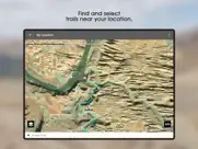
What is funtreks 4x4 offroad trails app? This app is not intended to be used alone, but rather as a GPS companion to FunTreks 4x4 guidebooks. It contains over 600 of the most popular offroad trails in selected areas of Colorado, California, Arizona and Moab, Utah. These amazing places are the last vestiges in America where 4-wheeling and backcountry exploration reign supreme.
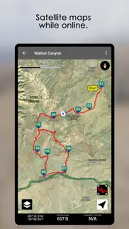
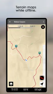
FunTreks is a small company in Colorado that has been publishing top-selling off-road guidebooks for more than 20 years. The app provides GPS track logs and waypoints that exactly match the trails in their books.
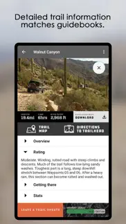
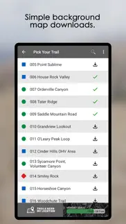
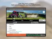
All trails have been driven, documented and GPS tracked by FunTreks scouts. The app includes trail descriptions, difficulty ratings, directions to the start, length of the trail, driving times, highest elevation, contact information, and best times to go.
To learn more about FunTreks guidebooks and to get additional trail information, visit www.FunTreks.com.
😍 Do you love FunTreks 4x4 Offroad Trails app? Please share your friends!

Please wait! FunTreks 4x4 Offroad Trails app comments loading...
FunTreks 4x4 Offroad Trails 3.0.3 Tips, Tricks, Cheats and Rules
What do you think of the FunTreks 4x4 Offroad Trails app? Can you share your complaints, experiences, or thoughts about the application with FunTreks Inc. and other users?
FunTreks 4x4 Offroad Trails 3.0.3 Apps Screenshots & Images
FunTreks 4x4 Offroad Trails iphone, ipad, apple watch and apple tv screenshot images, pictures.
| Language | English |
| Price | $59.99 |
| Adult Rating | 4+ years and older |
| Current Version | 3.0.3 |
| Play Store | com.FunTreks.FunTreksApp |
| Compatibility | iOS 14.0 or later |
FunTreks 4x4 Offroad Trails (Versiyon 3.0.3) Install & Download
The application FunTreks 4x4 Offroad Trails was published in the category Navigation on 27 June 2016, Monday and was developed by FunTreks Inc. [Developer ID: 1051880941]. This program file size is 83.57 MB. This app has been rated by 29 users and has a rating of 3.3 out of 5. FunTreks 4x4 Offroad Trails - Navigation app posted on 17 November 2022, Thursday current version is 3.0.3 and works well on iOS 14.0 and higher versions. Google Play ID: com.FunTreks.FunTreksApp. Languages supported by the app:
EN Download & Install Now!| App Name | Score | Comments | Price |
New version includes: - fix for app shutdown when caching trails - fix for app shutdown in Trail Map screen or Trails Near My Location screen - fix for navigation order
| App Name | Released |
| Spoten Phone Location Tracker | 06 December 2018 |
| A-Way WeGo | 28 November 2021 |
| Premium Parking | 22 October 2013 |
| ParkMobile - Find Parking | 04 April 2010 |
| NAVER Map, Navigation | 01 May 2009 |
Find on this site the customer service details of FunTreks 4x4 Offroad Trails. Besides contact details, the page also offers a brief overview of the digital toy company.
| App Name | Released |
| BLM Public Lands Map Guide USA | 27 December 2020 |
| CDOT Colorado Road Conditions | 21 October 2020 |
| Villages GPS | 02 December 2013 |
| Ship Finder | 01 April 2010 |
| Distance Calculator Pro | 19 January 2017 |
Discover how specific cryptocurrencies work — and get a bit of each crypto to try out for yourself. Coinbase is the easiest place to buy and sell cryptocurrency. Sign up and get started today.
| App Name | Released |
| Google Drive | 28 June 2012 |
| Messenger | 09 August 2011 |
| WhatsApp Messenger | 03 May 2009 |
| CapCut - Video Editor | 14 April 2020 |
| Microsoft Teams | 02 November 2016 |
Looking for comprehensive training in Google Analytics 4? We've compiled the top paid and free GA4 courses available in 2024.
| App Name | Released |
| HotSchedules | 30 October 2008 |
| Muse Dash | 14 June 2018 |
| Poppy Playtime Chapter 2 | 15 August 2022 |
| Terraria | 28 August 2013 |
| Incredibox | 27 March 2016 |
Each capsule is packed with pure, high-potency nootropic nutrients. No pointless additives. Just 100% natural brainpower. Third-party tested and validated by the Clean Label Project.
Adsterra is the most preferred ad network for those looking for an alternative to AdSense. Adsterra is the ideal choice for new sites with low daily traffic. In order to advertise on the site in Adsterra, like other ad networks, a certain traffic limit, domain age, etc. is required. There are no strict rules.
The easy, affordable way to create your professional portfolio website, store, blog & client galleries. No coding needed. Try free now.
FunTreks 4x4 Offroad Trails Comments & Reviews 2024
We transfer money over €4 billion every month. We enable individual and business accounts to save 4 million Euros on bank transfer fees. Want to send free money abroad or transfer money abroad for free? Free international money transfer!
Update looks awesome. Can’t wait to use it. Great improvements.
Nice App. Nice iPhone app that augments the excellent Charles Wells Off-Road Guidebooks to help you navigate in and out of all the good trails in the southwest.
Tim. Where does this very expensive app declare it is only for a few western US states? Very disappointing.
Buy only if you have the books. ****EDIT: upping this to 3 star due to plethora of trails available to get you inspired where to go; still you need the books for a broader picture; One important aspect: difficulty ratings are still a problem; 3 levels of difficulty is not sufficient; I used this extensively in last year and I can say often ‘stock 4x4 suv’ may not be able to cross some areas in the easy flagged trails; just be cautious if you have a ‘stock 4x4 suv’ since there are too many pseudo 4x4 suv out there nowadays. Remember the authors are very experienced off roaders so them driving a stock 4x4 is not the same as you and I**** I have the books but since they are useless without a track, I had to buy the app just to get the tracks. If you off road, you know that there is very likely there will be many off shoots and confusing intersections when you adventure. No book could compensate for an actual gpx track. Since I have the books from this company but in the field is very cumbersome to use, I had to buy the tracks. Now for the app review The only good: Is needed in conjuncture with the books The bad: - inconsistent trail ratings (i.e. found same trail in Phoenix area is rated both blue and red) - rating system green blue black is absolutely not sufficient to grade off road trails, a scale of 1 to 10 would be better (i.e. I went on some blue trails that were not equal, one would have been a 4 and the other more like a 6 and that is a big difference) - you cannot download the satellite view for the surrounding area next to the track (there are free open source satellite view maps and I do not know why they did not bother to at least make the surrounding area next to a track downloadable); as soon as you lose signal, you lose the satellite view (and you always lose cell signal off-road) - price is high when only purpose is to complement the books In short, there are better free sources with very detailed description and photos and gpx tracks that you can use if you have a gps unit or other navigation app you could import. Overall I find the book and app combo from Fun Treks to be just average. I just use them to get a general idea what trail to search for in an area I travel.
Book is Better. *Recommend book AND app* I already have a book so I thought the app would be great in order for me to keep my eyes on the trail. Great in theory buy not in practice. While this app will get you to the trail head, or the end, you won't get much out of it after that other than a pink line showing the suggested route. Directions to the trailhead use Apple maps so if you have Apple Carplay and want to see it on the bigger screen it's great. But now that you are there you have to use the apps map to see the highlighted pink route... which isn't projected on the head unit cause Carplay doesn't work with 3rd party apps. Even if you install the specific trail map to your device, get to the trailhead, then decide to have the app route you to the end of the trail using the default Apple Maps it won't work cause you probably have no service. I found myself still using the book and glancing down every once in awhile to make sure I was on the right path but the book is written so well you don't need the app. This is not a $60 app IMO since it doesn't replace the book but is a minor supplementation to it. Make it $20 and it's easier to justify but you can get to the trailhead using the GPS coordinates in the book and download offline maps using Google. Without turn by turn directions and Apple's inability to display 3rd party apps as of writing this there's not much to see here.
Worst offroad app. I’ve been very happy with the series of books to discover trails in multiple state. This app is extremely expensive at $60 and now feels to me like a complete rip-off. This app just offers you the GPS track in pink. It is not color coded like in the books. You need to refer to the book to see the color of the current portion of the trail. None of the book text is present in the App. You still need to hold the book in your hands while driving. I had dowloaded the offline map for my trail. The map is basically useless : best case, it’s just yellow. you do not see the other roads. At an intersection, there is no intersection, just the pink track you’re on. So no way to know if a bypass or a shortcut exists. Refer to a paper map for that. Worst case, the screen turns black, the pink track disappears and you just have a blue dot in the middle of the black screen. Of course it happened to me while I was navigating tight switchbacks with scary drops on the side in Moab. ( I wish I could add screenshots to this review to show you how bad it is). Finally, unlike Google Maps, Apple Maps, this app does not keep the screen on. While getting bashed on boulders in steep descents, I had to constantly reenter my six digit passcode to wake up the phone. This app is a complete rip-off. I wish I could be refunded. You’re way better drawing your GPX track into Gaia than using this app.
Outstanding app. This app is a great compliment to the books. It has kept us on the correct trail more several times. It’s great having accurate GPS support to always know exact position on the trail. Well worth the cost.
Excellent App!. Had been using their SD card in a small screen B&W GPS device before downloading this app. Great development effort. Trails are very clearly depicted in full color on my iPhone 6S Plus. Love that the developer provided Apple/Google maps directions to the trailhead. Only minor opportunity for improvement is when the device is on the edge of cell service, I get repeated pop-up warnings that the app is going into offline mode. Would like an option to permanently dismiss these pop-ups as they can get annoying after awhile. Definitely recommend this app for off roaders!
Worth the money!. It’s best to have the book and the app, the book gives more detailed information about the trail and obstacles. I find the app invaluable for telling me exactly where I am on the trail. Sometimes there are lots of forks and no signs. Without this app, I’d do a lot of backtracking and get lost a lot. And when we explore side trails, we always know exactly how to get back to the main trail. I download the maps offline for each trail I plan on running so no cell coverage needed. Having access to ALL the trails from every book makes this a must have app.
Easy to use. I use this app all the time in Arizona. I wish they had more states like Nevada and southwest Utah. It works great and is very precise.
It’s okay. There’s no way to do a search. You have to pick the version and then scroll down the list till you find what you are looking for. It’s organized by the trail ID based on the book. No sort function to search alphabetical.
Disappointed NOTHING like the book. Bought the book, thought the app was like the book but I would have gps while riding. It ONLY shows the trail location and waypoints but NO information on the waypoints, no staging area markings, doesn't show different levels of difficulty of trails (all trails are PINK in color not green for easy, blue, brown for gravel roads, then red difficult etc). So basically it has the trail in pink and that's IT!!!! I'll keep it because I have the AZ book and I can use it to track my location on the trail but otherwise you need to buy the book to get the real info. DISAPPOINTED!!!! Don't buy the app!!!
Mixed thoughts. I love the ability to download maps for offline use but have some dislikes. This has the potential to be a winner if it simplifies the user-interface AND adds Apple CarPlay integration
Great app. I used the app this week in Taylor Park, Colorado. It is a great companion with their books. You can see exactly where you are on the trail in real time. Easier than looking at a map and having to guess where you are on the trail. I have a mount for my IPAD mini in my Polaris RZR so that I can just look up and see exactly where I am on the trails.
Maps. Works great just wish the maps worked better off line ..
Great Info, Poor App. The guides (books) are the best, the app is ok at best. The app limits zoom for download, yet almost all the routes are in areas with NO CELL COVERAGE! So why bother with the app if you can’t download for off grid use? The app also “works” on iPad, BUT only in portrait and magnified from phone sized window, NOT higher resolution so there is limited value in using an iPad. Bottom line great company, great data, needs major app update. (I did download for disconnected use but it barely works.) In the end I paid for a different app which worked great even with downloaded map data in no cell coverage areas which is most of the routes.
Best off-road App I've used. I moved to northern Colorado 3 years ago with the intent to explore as much of this beautiful state as possible. I had no idea about the hundreds of off-road trails in this state until I bought the FunTreks guide book at a local 4x4 shop. I hit every trail possible. It wasn't until I went to Moab and forgot to pickup a trail guide that I realized FunTreks had an App. I bought the app and downloaded all the trails I wanted to hit while in Moab. Love this App. It works hand in hand with my guidebook and makes me feel at ease knowing the app works with my GPS when I'm out of service. Great job guys. Can't wait to see what's next.
Did you know that you can earn 25 USD from our site just by registering? Get $25 for free by joining Payoneer!
Imagine you at your best. All the time. Picture yourself at your sharpest and most productive. Your most alert and focused. Your most lucid, creative and confident. At work. At play. In every area of your life. Add Mind Lab Pro® v4.0 to your daily routine and uncap your true potential. Buy Now!
Adsterra is the most preferred ad network for those looking for an alternative to AdSense. Adsterra is the ideal choice for new sites with low daily traffic. In order to advertise on the site in Adsterra, like other ad networks, a certain traffic limit, domain age, etc. is required. There are no strict rules. Sign up!